Enable Location

We need your location to show you interesting places around you

Discover nearby places

Find interesting locations and hidden gems around you

Precise directions

Get accurate directions and distances to places

Your location is never shared with other users. It's only used when you tap the location button.

Berryessa Snow Mountain National Monument

Log in to your account

Start exploring — it's free

Trusted by 63,011 travelers worldwide

Continue with Google
Continue with Apple
or

We will send you a code to connect

By continuing, you accept our Terms and Conditions and our Privacy Policy

Check your inbox

We've sent a pincode in your inbox. Please enter the code below.

Berryessa Snow Mountain National Monument
Discussion Reviews 1 Photos
9.6k Popularity

Berryessa Snow Mountain National Monument, Nature reserve in Solano County, California, US.

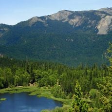
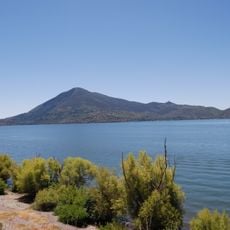
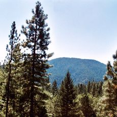
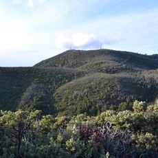
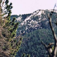
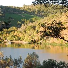
Berryessa Snow Mountain National Monument is a large protected landscape in northern California that stretches across seven counties and includes the mountains surrounding Lake Berryessa. The area combines river valleys, rugged terrain, and high ridgelines in a single vast preserve.

The area was designated as a national monument in 2015 by President Barack Obama to permanently protect over 330,000 acres from development. This action used the Antiquities Act to safeguard the region's natural resources and cultural heritage.

Eight Native American peoples, including the Yuki, Nomlaki, and Patwin nations, have deep roots in this landscape spanning thousands of years. Their presence remains woven into the land's ecology and the way the region functions today.

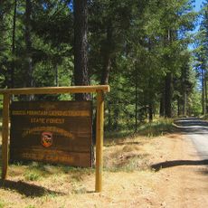
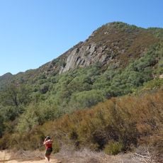
The preserve can be explored through hiking trails across varying terrain, paddling on Cache Creek for those interested in white water, or driving designated routes with four-wheel-drive vehicles. Visitors should plan activities based on season and weather conditions and carry adequate water and supplies.

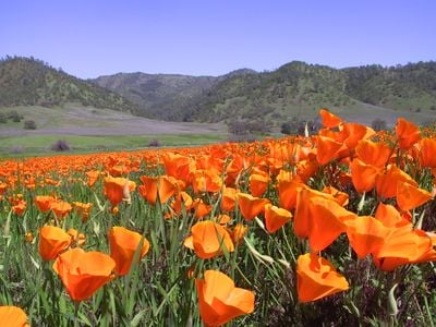
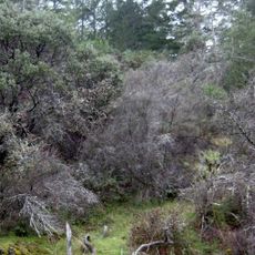
The preserve is home to rare plants that grow in nutrient-poor soils and have adapted to extreme drought and heat. These specialized plants thrive where toxic minerals in the ground would kill most other species.

The community of curious travelers

AroundUs brings together thousands of curated places, local tips, and hidden gems, enriched daily by 60,000 contributors worldwide.

Start exploring
Location
Operator
United States Forest Service;Bureau of Land Management
GPS coordinates
39.08760,-122.54727
Latest update
December 8, 2025 19:54
Around this place
Monticello Dam
United States of America

Monticello Dam

74.6 km
Chateau Montelena
United States of America

Chateau Montelena

54 km
Castello di Amorosa
United States of America

Castello di Amorosa

58.9 km
Korbel Champagne Cellars
United States of America

Korbel Champagne Cellars

74.1 km
Beringer Vineyards
United States of America

Beringer Vineyards

64.5 km
Mendocino National Forest
United States of America

Mendocino National Forest

61.9 km
Valle de Napa
United States of America

Valle de Napa

68.3 km
Petrified Forest
United States of America

Petrified Forest

59.7 km
Sutter Home Winery
United States of America

Sutter Home Winery

66.9 km
Mount Konocti
United States of America

Mount Konocti

22.8 km
Charles M. Schulz Museum and Research Center
United States of America

Charles M. Schulz Museum and Research Center

71.7 km
Beaulieu Vineyard
United States of America

Beaulieu Vineyard

70.7 km
Heitz Wine Cellars
United States of America

Heitz Wine Cellars

66.2 km
Safari West
United States of America

Safari West

60.4 km
Cobb Mountain
United States of America

Cobb Mountain

35.4 km
Robert Louis Stevenson State Park
United States of America

Robert Louis Stevenson State Park

48.6 km
Bothe-Napa Valley State Park
United States of America

Bothe-Napa Valley State Park

59.8 km
Sacramento National Wildlife Refuge Complex
United States of America

Sacramento National Wildlife Refuge Complex

49.2 km
Snow Mountain Wilderness
United States of America

Snow Mountain Wilderness

39.6 km
Schramsberg Vineyards
United States of America

Schramsberg Vineyards

59.8 km
Clear Lake State Park
United States of America

Clear Lake State Park

24.2 km
Pacific Coast Air Museum
United States of America

Pacific Coast Air Museum

68.4 km
Anderson Marsh State Historic Park
United States of America

Anderson Marsh State Historic Park

19.3 km
Charles Krug Winery
United States of America

Charles Krug Winery

63.7 km
Boggs Mountain Demonstration State Forest
United States of America

Boggs Mountain Demonstration State Forest

32.2 km
J Vineyards & Winery
United States of America

J Vineyards & Winery

62.8 km
Stebbins Cold Canyon Reserve
United States of America

Stebbins Cold Canyon Reserve

75.3 km
Elmshaven
United States of America

Elmshaven

61.6 km
Show the full map
Reviews
Share your experience

No review yet

Discussions
Start a discussion...

No discussion yet

« Berryessa Snow Mountain National Monument - Nature reserve in Solano County, California, US » is provided by Around Us (aroundus.com). Images and texts are derived from Wikimedia project under a Creative Commons license. You are allowed to copy, distribute, and modify copies of this page, under the conditions set by the license, as long as this note is clearly visible.

Discover hidden gems everywhere you go!

From secret cafés to breathtaking viewpoints, skip the crowded tourist spots and find places that match your style. Our app makes it easy with voice search, smart filtering, route optimization, and insider tips from travelers worldwide. Download now for the complete mobile experience.

Around Us App Screenshot

A unique approach to discovering new places

Le Figaro

All the places worth exploring

France Info

A tailor-made excursion in just a few clicks

20 Minutes

Around Us
Travel Guide & Maps
Download

Send to your phone

QR Code
1

Open the camera app on your mobile.

2

Point at the QR code with your camera. A notification will appear.

3

Tap the notification to open the link.