Enable Location

We need your location to show you interesting places around you

Discover nearby places

Find interesting locations and hidden gems around you

Precise directions

Get accurate directions and distances to places

Your location is never shared with other users. It's only used when you tap the location button.

Fort Lincoln

Log in to your account

Start exploring — it's free

Trusted by 69,915 travelers worldwide

Continue with Google
Continue with Apple
or

We will send you a code to connect

By continuing, you accept our Terms and Conditions and our Privacy Policy

Check your inbox

We've sent a pincode in your inbox. Please enter the code below.

Discussion Reviews 1 Photos
2.6k Popularity

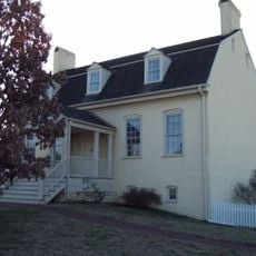
Fort Lincoln, Civil War fort in northeast Washington D.C., United States

Fort Lincoln is a Civil War military fortification in northeast Washington, D.C., featuring earthwork defenses and open-air pavilions spread across the grounds. The site includes an amphitheater, connecting ramps for accessibility, and multiple levels designed for visitor movement through the terrain.

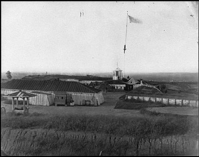
The fort was built in 1861 as part of Washington's defensive line to protect the capital during the Civil War. It served as one of several fortifications that formed a protective ring around the city during the conflict.

The site is part of a network of parks that preserves the city's Civil War history for visitors and residents alike. These connected spaces help people today walk through and understand what this period meant for the capital.

The park is easily accessible through ramps and level walkways, with seating areas distributed throughout the grounds. Visitors can take time exploring the different levels and spending time at the pavilions and amphitheater.

The grounds feature a brick climbing pyramid with a moat and play areas built into the terrain that reference historical fortifications. These modern additions blend historical inspiration with active recreation for families visiting the site.

The community of curious travelers

AroundUs brings together thousands of curated places, local tips, and hidden gems, enriched daily by 60,000 contributors worldwide.

Start exploring
Location
Inception
1861
Elevation above the sea
55 m
Part of
Civil War defenses of Washington, D.C., Fort Circle Parks
GPS coordinates
38.92670,-76.95650
Latest update
December 18, 2025 11:40
Around this place
United States National Arboretum
United States of America

United States National Arboretum

2 km
National Capitol Columns
United States of America

National Capitol Columns

2.1 km
Northeast
United States of America

Northeast

2.3 km
Peace Cross
United States of America

Peace Cross

2 km
Goshin
United States of America

Goshin

1.7 km
Mount St. Sepulchre Franciscan Monastery
United States of America

Mount St. Sepulchre Franciscan Monastery

2.8 km
Langston Golf Course
United States of America

Langston Golf Course

2.8 km
Bladensburg Dueling Grounds
United States of America

Bladensburg Dueling Grounds

1.4 km
Hecht Company Warehouse
United States of America

Hecht Company Warehouse

2.8 km
Northwest Branch Anacostia River
United States of America

Northwest Branch Anacostia River

2.1 km
Kenilworth Park and Aquatic Gardens
United States of America

Kenilworth Park and Aquatic Gardens

2 km
Northwest Branch Trail
United States of America

Northwest Branch Trail

2.4 km
Bostwick
United States of America

Bostwick

2.3 km
George Washington House
United States of America

George Washington House

2.1 km
Amtrak Railroad Anacostia Bridge
United States of America

Amtrak Railroad Anacostia Bridge

1.5 km
Mayfair Mansions Apartments
United States of America

Mayfair Mansions Apartments

2.7 km
Fort Saratoga
United States of America

Fort Saratoga

1.9 km
William Hilleary House
United States of America

William Hilleary House

2.1 km
Ralph Bunche House
United States of America

Ralph Bunche House

2.4 km
Market Master's House
United States of America

Market Master's House

2.2 km
New York Avenue Bridge
United States of America

New York Avenue Bridge

1.6 km
Woodridge Neighborhood Library
United States of America

Woodridge Neighborhood Library

1.9 km
Bladensburg Road Bridge
United States of America

Bladensburg Road Bridge

1.8 km
Mount Rainier Historic District
United States of America

Mount Rainier Historic District

1.5 km
North Brentwood Historic District
United States of America

North Brentwood Historic District

2 km
Bladensburg Park Pedestrian Bridge
United States of America

Bladensburg Park Pedestrian Bridge

1.7 km
National Bonsai and Penjing Museum
United States of America

National Bonsai and Penjing Museum

1.9 km
Lucy Diggs Slowe Elementary School
United States of America

Lucy Diggs Slowe Elementary School

2.6 km
Show the full map
Reviews
Share your experience

No review yet

Discussions
Start a discussion...

No discussion yet

« Fort Lincoln - Civil War fort in northeast Washington D.C., United States » is provided by Around Us (aroundus.com). Images and texts are derived from Wikimedia project under a Creative Commons license. You are allowed to copy, distribute, and modify copies of this page, under the conditions set by the license, as long as this note is clearly visible.

Discover hidden gems everywhere you go!

From secret cafés to breathtaking viewpoints, skip the crowded tourist spots and find places that match your style. Our app makes it easy with voice search, smart filtering, route optimization, and insider tips from travelers worldwide. Download now for the complete mobile experience.

Around Us App Screenshot

A unique approach to discovering new places

Le Figaro

All the places worth exploring

France Info

A tailor-made excursion in just a few clicks

20 Minutes

Around Us
Travel Guide & Maps
Download

Send to your phone

QR Code
1

Open the camera app on your mobile.

2

Point at the QR code with your camera. A notification will appear.

3

Tap the notification to open the link.