Enable Location

We need your location to show you interesting places around you

Discover nearby places

Find interesting locations and hidden gems around you

Precise directions

Get accurate directions and distances to places

Your location is never shared with other users. It's only used when you tap the location button.

Log in to your account

Start exploring — it's free

Trusted by 61,666 travelers worldwide

Continue with Google
Continue with Apple
or

We will send you a code to connect

By continuing, you accept our Terms and Conditions and our Privacy Policy

Check your inbox

We've sent a pincode in your inbox. Please enter the code below.

Mingo Creek Viaduct

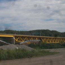
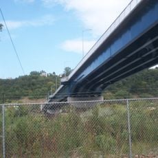
Mingo Creek Viaduct, Road bridge near Carroll Township, Washington County, US.

Description

Mingo Creek Viaduct is a road bridge composed of two parallel steel girder spans extending approximately 2,400 feet. The structure rises around 250 feet above Mingo Creek, Pennsylvania Route 88, and the Wheeling and Lake Erie Railway below.

History

This viaduct opened in 2002 and represented a major upgrade to transportation infrastructure in southwestern Pennsylvania. The completion improved traffic flow across the region and simplified connections over Mingo Creek and multiple transportation corridors.

Culture

The bridge is known locally as Joe Montana Bridges, named after the Pro Football Hall of Famer who attended nearby Ringgold High School. This connection links the structure to the region's sports heritage and local pride.

Practical

The bridge carries Pennsylvania Route 43 and can be viewed from various vantage points in the surrounding area. Best viewing spots are accessible from local roads that provide perspective on the structure's height and span.

Did you know?

This viaduct ranks among the tallest bridges in Pennsylvania, making it a notable engineering achievement in the state. Its impressive vertical scale demonstrates the engineering challenges overcome during its construction.

Inception
April 2002
Official opening
April 2002
GPS coordinates
40.20790,-79.98470
Latest update
December 12, 2025 09:01

AroundUs brings together thousands of curated places, local tips, and hidden gems, enriched daily by 60,000 contributors worldwide. Discover all places nearby (Washington County).

Around this place
Oliver Miller Homestead
United States of America

Oliver Miller Homestead

12.6 km
South Park
United States of America

South Park

12.6 km
Cement City Historic District
United States of America

Cement City Historic District

10.9 km
United States of America

Round Hill Park

12.9 km
Donora-Monessen Bridge
United States of America

Donora-Monessen Bridge

11.6 km
Edward G. Acheson House
United States of America

Edward G. Acheson House

4.4 km
Regis R. Malady Bridge
United States of America

Regis R. Malady Bridge

11.1 km
Donora-Webster Bridge
United States of America

Donora-Webster Bridge

11.6 km
Belle Vernon Bridge
United States of America

Belle Vernon Bridge

12.8 km
Ebenezer Covered Bridge
United States of America

Ebenezer Covered Bridge

5.1 km
Henry Covered Bridge
United States of America

Henry Covered Bridge

2.8 km
Van Kirk Farm
United States of America

Van Kirk Farm

11.1 km
Elizabeth Locks & Dam
United States of America

Elizabeth Locks & Dam

9.6 km
Speers Railroad Bridge
United States of America

Speers Railroad Bridge

12.7 km
Huffman Distillery and Chopping Mill
United States of America

Huffman Distillery and Chopping Mill

11.8 km
Charleroi-Monessen Bridge
United States of America

Charleroi-Monessen Bridge

9.3 km
Charleroi Locks & Dam
United States of America

Charleroi Locks & Dam

10 km
David Longwell House
United States of America

David Longwell House

4.6 km
Charleroi Historic District
United States of America

Charleroi Historic District

10.2 km
Enoch Wright House
United States of America

Enoch Wright House

6 km
Samuel Brownlee House
United States of America

Samuel Brownlee House

12.2 km
Hutchinson Farm (Elizabeth, Pennsylvania)
United States of America

Hutchinson Farm (Elizabeth, Pennsylvania)

10.8 km
Bethel African American Episcopal Church of Monongahela City
United States of America

Bethel African American Episcopal Church of Monongahela City

4.5 km
Cerl Wright Covered Bridge
United States of America

Cerl Wright Covered Bridge

7.7 km
Bridge in Jefferson Borough
United States of America

Bridge in Jefferson Borough

9.5 km
Dusmal House
United States of America

Dusmal House

5.3 km
First National Bank of Charleroi
United States of America

First National Bank of Charleroi

10.7 km
Jefferson Hills Public Library
United States of America

Jefferson Hills Public Library

11 km
Show the full map
« Mingo Creek Viaduct - Road bridge near Carroll Township, Washington County, US » is provided by Around Us (aroundus.com). Images and texts are derived from Wikimedia project under a Creative Commons license. You are allowed to copy, distribute, and modify copies of this page, under the conditions set by the license, as long as this note is clearly visible.

Discover hidden gems everywhere you go!

From secret cafés to breathtaking viewpoints, skip the crowded tourist spots and find places that match your style. Our app makes it easy with voice search, smart filtering, route optimization, and insider tips from travelers worldwide. Download now for the complete mobile experience.

Around Us App Screenshot

A unique approach to discovering new places

Le Figaro

All the places worth exploring

France Info

A tailor-made excursion in just a few clicks

20 Minutes

Around Us
Travel Guide & Maps
Download

Send to your phone

QR Code
1

Open the camera app on your mobile.

2

Point at the QR code with your camera. A notification will appear.

3

Tap the notification to open the link.