Enable Location

We need your location to show you interesting places around you

Discover nearby places

Find interesting locations and hidden gems around you

Precise directions

Get accurate directions and distances to places

Your location is never shared with other users. It's only used when you tap the location button.

Haggard Ford Swinging Bridge

Log in to your account

Start exploring — it's free

Trusted by 62,472 travelers worldwide

Continue with Google
Continue with Apple
or

We will send you a code to connect

By continuing, you accept our Terms and Conditions and our Privacy Policy

Check your inbox

We've sent a pincode in your inbox. Please enter the code below.

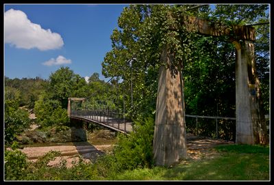
Haggard Ford Swinging Bridge, suspension bridge in Boone County, Arkansas

Haggard Ford Swinging Bridge is a suspension structure made of wood and concrete that spans Bear Creek near Harrison, Arkansas. It features a single span held up by steel cables connected to concrete towers, with a wooden deck beneath your feet as you cross.

Built between 1938 and 1941 with funding from the Works Progress Administration, the bridge provided jobs for local workers during the Great Depression. A major flood in 1961 damaged it so severely that it was closed to vehicles and remained for foot traffic only.

The bridge carries the name of Nancy Haggard, a woman who settled near this crossing in the late 1800s. Today, visitors can see how the community continues to care for this landmark through simple markers and maintenance, making it a gathering point for those who value local heritage.

You can reach the bridge from Cottonwood Road just north of Harrison, and it offers a quiet place for a walk. The wooden deck may be slippery when wet, so wear good shoes and take care during bad weather.

Only three such WPA-era bridges remain standing in Arkansas out of over twenty built, making this one a rare survivor of a lost building style. Local residents saved it from demolition in the late 1970s by raising funds through selling engraved wooden planks, turning restoration into a community effort.

The community of curious travelers

AroundUs brings together thousands of curated places, local tips, and hidden gems, enriched daily by 60,000 contributors worldwide.

Start exploring
Location
Inception
1941
Made from material
concrete, wood
GPS coordinates
36.34580,-93.13060
Latest update
February 9, 2026 07:42
Around this place
Table Rock Lake
United States of America

Table Rock Lake

28.9 km
Dogpatch USA
United States of America

Dogpatch USA

26.6 km
Ozark Medieval Fortress
United States of America

Ozark Medieval Fortress

11.7 km
Showboat Branson Belle
United States of America

Showboat Branson Belle

31.6 km
Table Rock State Park
United States of America

Table Rock State Park

31.3 km
Elliott and Anna Barham House
United States of America

Elliott and Anna Barham House

20.4 km
Harrison Courthouse Square Historic District
United States of America

Harrison Courthouse Square Historic District

13 km
Hotel Seville
United States of America

Hotel Seville

12.8 km
Downing Street Historic District
United States of America

Downing Street Historic District

31.8 km
Cricket and Crest Tunnels
United States of America

Cricket and Crest Tunnels

12.2 km
Boone County Courthouse
United States of America

Boone County Courthouse

13 km
Parker-Hickman Farm Historic District
United States of America

Parker-Hickman Farm Historic District

31.7 km
Green Forest Water Tower
United States of America

Green Forest Water Tower

27.4 km
Yell Masonic Lodge Hall
United States of America

Yell Masonic Lodge Hall

19.5 km
Shady Grove Delmar Church and School
United States of America

Shady Grove Delmar Church and School

28.4 km
Buffalo River Bridge
United States of America

Buffalo River Bridge

31.7 km
Crooked Creek Bridge
United States of America

Crooked Creek Bridge

27.9 km
Dog Branch School
United States of America

Dog Branch School

25.8 km
Mo-Ark Baptist Academy
United States of America

Mo-Ark Baptist Academy

29.4 km
Harp Creek Bridge
United States of America

Harp Creek Bridge

29.3 km
Grubb Springs School
United States of America

Grubb Springs School

14.1 km
Everton School
United States of America

Everton School

29.4 km
Evans-Kirby House
United States of America

Evans-Kirby House

13.5 km
Eros School Building
United States of America

Eros School Building

31 km
W.D. Crawford House
United States of America

W.D. Crawford House

33.1 km
Pyatt School Building
United States of America

Pyatt School Building

28 km
Lyric Theatre
United States of America

Lyric Theatre

12.9 km
Moonshine Beach
United States of America

Moonshine Beach

33.3 km
Show the full map
« Haggard Ford Swinging Bridge - suspension bridge in Boone County, Arkansas » is provided by Around Us (aroundus.com). Images and texts are derived from Wikimedia project under a Creative Commons license. You are allowed to copy, distribute, and modify copies of this page, under the conditions set by the license, as long as this note is clearly visible.

Discover hidden gems everywhere you go!

From secret cafés to breathtaking viewpoints, skip the crowded tourist spots and find places that match your style. Our app makes it easy with voice search, smart filtering, route optimization, and insider tips from travelers worldwide. Download now for the complete mobile experience.

Around Us App Screenshot

A unique approach to discovering new places

Le Figaro

All the places worth exploring

France Info

A tailor-made excursion in just a few clicks

20 Minutes

Around Us
Travel Guide & Maps
Download

Send to your phone

QR Code
1

Open the camera app on your mobile.

2

Point at the QR code with your camera. A notification will appear.

3

Tap the notification to open the link.