Peoria Lock and Dam

Log in to your account

AroundUs is a community-driven map of interesting places, built by curious explorers like you. It grows with every review, story, and photo you share.
Connect to save your favorite spots, contribute locations, and create personalized routes.
Continue with Google
Continue with Apple
Continue with X
Continue with Facebook
Continue with email
By continuing, you accept our Terms and Conditions and our Privacy Policy
Create an account
Add to collection
Map
Suggest a change
Share

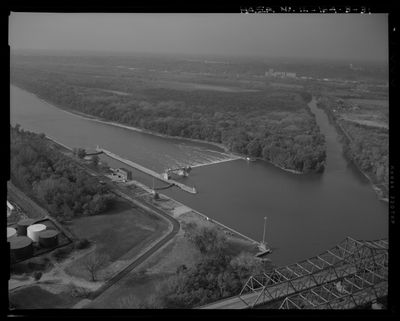
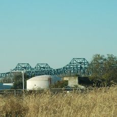
Peoria Lock and Dam, Navigation lock and dam system on Illinois River at Creve Coeur, United States

Peoria Lock and Dam is a navigation system on the Illinois River at Creve Coeur that allows vessels to pass between different water levels. The lock chamber spans 100 feet (30 meters) wide and 600 feet (180 meters) long, with a lifting capacity of 11 feet (3 meters) to accommodate commercial boats traveling upriver and downriver.

The U.S. Army Corps of Engineers built this system between 1938 and 1939 to improve boat passage between Chicago and the Mississippi River. This project was part of a larger effort to develop the Illinois River waterway for commercial transportation during that era.

The control station displays Art Deco details at its entrance, showing how federal projects of the 1930s favored this modern design style. You can see geometric shapes and clean lines that were popular when this building was made.

This location provides a good vantage point to watch boats passing through the system and observe the working waterway. The best time to visit is during daylight hours when you can see the lock operations and get a clear view of how vessels move through the structure.

The dam contains 108 Chanoine wicket gates, making it one of only two structures in Illinois that still uses this historical engineering approach. These particular gates are rare examples of a disappearing technology found in just a handful of locations across America.

Location: Creve Coeur

Elevation above the sea: 137 m

GPS coordinates: 40.63195,-89.62500

Latest update: December 14, 2025 14:40

Photos
Around this place
Peoria Civic Center
United States of America

Peoria Civic Center

7.2 km
Fort Crevecoeur
United States of America

Fort Crevecoeur

2.4 km
Peoria Riverfront Museum
United States of America

Peoria Riverfront Museum

7 km
Murray Baker Bridge
United States of America

Murray Baker Bridge

7.1 km
Madison Theatre
United States of America

Madison Theatre

7.5 km
United States of America

Renaissance Coliseum

7.5 km
Bob Michel Bridge
United States of America

Bob Michel Bridge

6.5 km
Cedar Street Bridge
United States of America

Cedar Street Bridge

5.5 km
Peoria City Hall
United States of America

Peoria City Hall

7.3 km
Pettingill-Morron House
United States of America

Pettingill-Morron House

7 km
John T. McNaughton Bridge
United States of America

John T. McNaughton Bridge

6.8 km
West Bluff Historic District
United States of America

West Bluff Historic District

6.5 km
John C. Proctor Recreation Center
United States of America

John C. Proctor Recreation Center

6 km
Tazewell County Courthouse
United States of America

Tazewell County Courthouse

7.2 km
Shade-Lohmann Bridge
United States of America

Shade-Lohmann Bridge

400 m
Peoria Federal Building and U.S. Courthouse
United States of America

Peoria Federal Building and U.S. Courthouse

7.6 km
Peoria Cordage Company
United States of America

Peoria Cordage Company

5.7 km
Central National Bank Building
United States of America

Central National Bank Building

7.3 km
Peace and Harvest
United States of America

Peace and Harvest

7.3 km
Grand Army of the Republic Memorial Hall
United States of America

Grand Army of the Republic Memorial Hall

7.6 km
YWCA Building
United States of America

YWCA Building

7.7 km
Cumberland Presbyterian Church
United States of America

Cumberland Presbyterian Church

7.2 km
Lincoln Branch Peoria Public Library
United States of America

Lincoln Branch Peoria Public Library

5.6 km
Pekin Federal Building
United States of America

Pekin Federal Building

7.3 km
Downtown Peoria Historic District
United States of America

Downtown Peoria Historic District

7.4 km
Marquette Apartments
United States of America

Marquette Apartments

7.6 km
North Eighth Street Plaza
United States of America

North Eighth Street Plaza

5.8 km
Creve Coeur Public Library District
United States of America

Creve Coeur Public Library District

3 km
Show the full map
Reviews

Visited this place? Tap the stars to rate it and share your experience / photos with the community! Try now! You can cancel it anytime.

« Peoria Lock and Dam - Navigation lock and dam system on Illinois River at Creve Coeur, United States » is provided by Around Us (aroundus.com). Images and texts are derived from Wikimedia project under a Creative Commons license. You are allowed to copy, distribute, and modify copies of this page, under the conditions set by the license, as long as this note is clearly visible.

Discover hidden gems everywhere you go!

From secret cafés to breathtaking viewpoints, skip the crowded tourist spots and find places that match your style. Our app makes it easy with voice search, smart filtering, route optimization, and insider tips from travelers worldwide. Download now for the complete mobile experience.

Around Us App Screenshot

A unique approach to discovering new places

Le Figaro

All the places worth exploring

France Info

A tailor-made excursion in just a few clicks

20 Minutes