Enable Location

We need your location to show you interesting places around you

Discover nearby places

Find interesting locations and hidden gems around you

Precise directions

Get accurate directions and distances to places

Your location is never shared with other users. It's only used when you tap the location button.

Shade-Lohmann Bridge

Log in to your account

Start exploring — it's free

Trusted by 62,171 travelers worldwide

Continue with Google
Continue with Apple
or

We will send you a code to connect

By continuing, you accept our Terms and Conditions and our Privacy Policy

Check your inbox

We've sent a pincode in your inbox. Please enter the code below.

Shade-Lohmann Bridge

Shade-Lohmann Bridge, Road bridge in Bartonville, United States

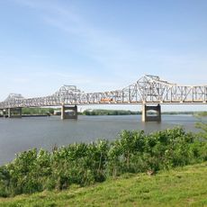
The Shade-Lohmann Bridge is a road bridge in Bartonville that carries Interstate 474 and US Route 24 across the Illinois River. It consists of two matching sections, one for westbound and one for eastbound traffic, each with four lanes and modern infrastructure.

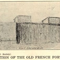
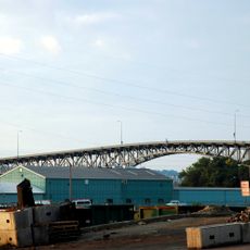
Construction of the twin cantilever structure took place between 1973 and 1975, connecting the communities of Bartonville and Creve Coeur. The structure has undergone major renovation work since to maintain its function and safety.

The bridge takes its name from J. Norman Shade, a former mayor of Pekin, and Martin B. Lohmann, who spent three decades in the Illinois Legislature. This naming choice honors local leaders who shaped the region.

Traffic flows across two separate deck structures, one for each direction, which simplifies traffic operations. Visitors looking to view the bridge can get the best perspective from the riverbanks on either side.

A major reconstruction modernized the structure with steel repairs, electrical upgrades, and sediment work on the bridge piers. This project demonstrates how older infrastructure can be restored through targeted maintenance efforts.

The community of curious travelers

AroundUs brings together thousands of curated places, local tips, and hidden gems, enriched daily by 60,000 contributors worldwide.

Start exploring
Location
Inception
1975
Official opening
1975
GPS coordinates
40.63504,-89.62260
Latest update
December 14, 2025 18:14
Around this place
Peoria Civic Center
United States of America

Peoria Civic Center

6.8 km
Fort Crevecoeur
United States of America

Fort Crevecoeur

2 km
Peoria Riverfront Museum
United States of America

Peoria Riverfront Museum

6.7 km
Murray Baker Bridge
United States of America

Murray Baker Bridge

6.7 km
Madison Theatre
United States of America

Madison Theatre

7.1 km
United States of America

Renaissance Coliseum

7.2 km
Bob Michel Bridge
United States of America

Bob Michel Bridge

6.1 km
Cedar Street Bridge
United States of America

Cedar Street Bridge

5.1 km
Taft Homes
United States of America

Taft Homes

7.5 km
Peoria City Hall
United States of America

Peoria City Hall

6.9 km
Pettingill-Morron House
United States of America

Pettingill-Morron House

6.7 km
John T. McNaughton Bridge
United States of America

John T. McNaughton Bridge

7.2 km
West Bluff Historic District
United States of America

West Bluff Historic District

6.2 km
Peoria Lock and Dam
United States of America

Peoria Lock and Dam

400 m
John C. Proctor Recreation Center
United States of America

John C. Proctor Recreation Center

5.6 km
Peoria Federal Building and U.S. Courthouse
United States of America

Peoria Federal Building and U.S. Courthouse

7.2 km
Peoria Cordage Company
United States of America

Peoria Cordage Company

5.3 km
Central National Bank Building
United States of America

Central National Bank Building

6.9 km
Peace and Harvest
United States of America

Peace and Harvest

7 km
Grand Army of the Republic Memorial Hall
United States of America

Grand Army of the Republic Memorial Hall

7.2 km
Cumberland Presbyterian Church
United States of America

Cumberland Presbyterian Church

6.8 km
YWCA Building
United States of America

YWCA Building

7.3 km
Lincoln Branch Peoria Public Library
United States of America

Lincoln Branch Peoria Public Library

5.2 km
Downtown Peoria Historic District
United States of America

Downtown Peoria Historic District

7 km
Marquette Apartments
United States of America

Marquette Apartments

7.2 km
North Eighth Street Plaza
United States of America

North Eighth Street Plaza

6.2 km
Judge Jacob Gale House
United States of America

Judge Jacob Gale House

7.4 km
Creve Coeur Public Library District
United States of America

Creve Coeur Public Library District

2.6 km
Show the full map
« Shade-Lohmann Bridge - Road bridge in Bartonville, United States » is provided by Around Us (aroundus.com). Images and texts are derived from Wikimedia project under a Creative Commons license. You are allowed to copy, distribute, and modify copies of this page, under the conditions set by the license, as long as this note is clearly visible.

Discover hidden gems everywhere you go!

From secret cafés to breathtaking viewpoints, skip the crowded tourist spots and find places that match your style. Our app makes it easy with voice search, smart filtering, route optimization, and insider tips from travelers worldwide. Download now for the complete mobile experience.

Around Us App Screenshot

A unique approach to discovering new places

Le Figaro

All the places worth exploring

France Info

A tailor-made excursion in just a few clicks

20 Minutes

Around Us
Travel Guide & Maps
Download

Send to your phone

QR Code
1

Open the camera app on your mobile.

2

Point at the QR code with your camera. A notification will appear.

3

Tap the notification to open the link.