Enable Location

We need your location to show you interesting places around you

Discover nearby places

Find interesting locations and hidden gems around you

Precise directions

Get accurate directions and distances to places

Your location is never shared with other users. It's only used when you tap the location button.

Fisher Covered Railroad Bridge

Log in to your account

Start exploring — it's free

Trusted by 61,348 travelers worldwide

Continue with Google
Continue with Apple
or

We will send you a code to connect

By continuing, you accept our Terms and Conditions and our Privacy Policy

Check your inbox

We've sent a pincode in your inbox. Please enter the code below.

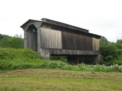
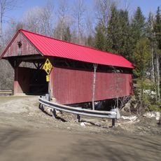
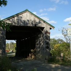
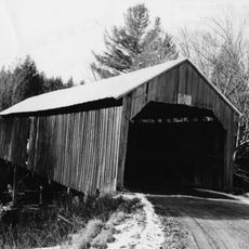
Fisher Covered Railroad Bridge, Historic railway bridge in Wolcott, United States.

Description

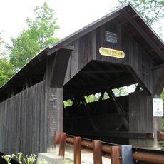
The Fisher Covered Railroad Bridge is a wooden railway bridge with a double lattice frame and board siding that crosses the Lamoille River. It has a long, narrow enclosed form with a distinctive ventilation shaft running along its center to allow steam locomotives to pass through safely.

History

The bridge was built in 1908 by the Boston & Maine Railroad to serve the St. Johnsbury and Lamoille County rail line. It operated until 1994 when the rail line was abandoned, though it had already been listed for historic protection in 1974.

Culture

The bridge carries the name of its original developer and reflects how early railroad engineers in this region built with timber and careful design. The central ventilation opening visible along the roof shows how builders solved the practical problem of steam locomotives operating through enclosed spaces.

Practical

The best way to see it is to approach on foot from the roadside or nearby pathways, as the bridge itself is not open for crossing. The entire structure is visible from the ground, so any time of day works well for viewing.

Did you know?

This was the last covered railroad bridge in Vermont that still saw active train traffic, making it uniquely preserved until modern times. Steel reinforcement added in 1968 saved the original wooden frame from demolition and allowed it to continue serving its purpose much longer than anyone expected.

Location
Inception
1908
Made from material
wood
GPS coordinates
44.53230,-72.42769
Latest update
December 14, 2025 14:25

AroundUs brings together thousands of curated places, local tips, and hidden gems, enriched daily by 60,000 contributors worldwide. Discover all places nearby (Wolcott).

Around this place
Gold Brook Covered Bridge
United States of America

Gold Brook Covered Bridge

22.5 km
Elmore State Park
United States of America

Elmore State Park

9 km
Peoples Academy
United States of America

Peoples Academy

13.3 km
Green River Reservoir State Park
United States of America

Green River Reservoir State Park

12.7 km
Red Covered Bridge
United States of America

Red Covered Bridge

19.9 km
Molly's Falls Pond State Park
United States of America

Molly's Falls Pond State Park

21.2 km
Stowe Village Historic District
United States of America

Stowe Village Historic District

21.8 km
Power House Covered Bridge
United States of America

Power House Covered Bridge

22.5 km
The Current
United States of America

The Current

21.8 km
Scribner Covered Bridge
United States of America

Scribner Covered Bridge

21.1 km
Methodist Episcopal Church
United States of America

Methodist Episcopal Church

17 km
Cobb School
United States of America

Cobb School

7.3 km
Waterman Covered Bridge
United States of America

Waterman Covered Bridge

22.1 km
Worcester Town Hall
United States of America

Worcester Town Hall

20.2 km
Lamoille River Route 15-A Bridge
United States of America

Lamoille River Route 15-A Bridge

11.6 km
Lamoille County Courthouse
United States of America

Lamoille County Courthouse

16.5 km
Morrisville Historic District
United States of America

Morrisville Historic District

14.1 km
Kents Corner Historic District
United States of America

Kents Corner Historic District

19.2 km
Christian Union Society Meetinghouse
United States of America

Christian Union Society Meetinghouse

12.4 km
Downtown Hardwick Village Historic District
United States of America

Downtown Hardwick Village Historic District

5.9 km
District Number Four School
United States of America

District Number Four School

12.5 km
Hardwick Street Historic District
United States of America

Hardwick Street Historic District

10.4 km
North Calais Village Historic District
United States of America

North Calais Village Historic District

15.8 km
Woodbury Town Hall
United States of America

Woodbury Town Hall

10.3 km
Building at 143 Highland Avenue
United States of America

Building at 143 Highland Avenue

5.5 km
Worcester Village School
United States of America

Worcester Village School

20.2 km
Stannard Schoolhouse
United States of America

Stannard Schoolhouse

17 km
Lake Elmore
United States of America

Lake Elmore

7.7 km
Show the full map
« Fisher Covered Railroad Bridge - Historic railway bridge in Wolcott, United States » is provided by Around Us (aroundus.com). Images and texts are derived from Wikimedia project under a Creative Commons license. You are allowed to copy, distribute, and modify copies of this page, under the conditions set by the license, as long as this note is clearly visible.

Discover hidden gems everywhere you go!

From secret cafés to breathtaking viewpoints, skip the crowded tourist spots and find places that match your style. Our app makes it easy with voice search, smart filtering, route optimization, and insider tips from travelers worldwide. Download now for the complete mobile experience.

Around Us App Screenshot

A unique approach to discovering new places

Le Figaro

All the places worth exploring

France Info

A tailor-made excursion in just a few clicks

20 Minutes

Around Us
Travel Guide & Maps
Download

Send to your phone

QR Code
1

Open the camera app on your mobile.

2

Point at the QR code with your camera. A notification will appear.

3

Tap the notification to open the link.