Enable Location

We need your location to show you interesting places around you

Discover nearby places

Find interesting locations and hidden gems around you

Precise directions

Get accurate directions and distances to places

Your location is never shared with other users. It's only used when you tap the location button.

Corona Satellite Calibration Targets

Log in to your account

Start exploring — it's free

Trusted by 61,688 travelers worldwide

Continue with Google
Continue with Apple
or

We will send you a code to connect

By continuing, you accept our Terms and Conditions and our Privacy Policy

Check your inbox

We've sent a pincode in your inbox. Please enter the code below.

Corona Satellite Calibration Targets

Corona Satellite Calibration Targets, Cold War calibration site in Casa Grande, Arizona, US.

Description

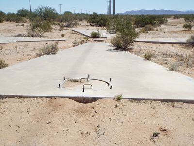
The Corona Satellite Calibration Targets are a grid of white concrete Maltese crosses spread across the desert landscape near Casa Grande. Each cross was designed as a reference marker for aerial photography and precise ground verification.

History

The US Army Map Service created this test range in the 1960s to validate aerial survey cameras and improve mapping technology. The site was designed to calibrate surveillance satellites and ensure the accuracy of their imagery.

Culture

The concrete crosses represent how Americans developed new ways to map and monitor land from the air during a time of global tension. These markers show the importance that precision mapping held for military planning and defense strategies of that era.

Practical

Two of the original crosses remain visible at the intersections of South Montgomery and West Cornman Roads, and at West Cornman Road and Carmel Boulevard. Plan to visit during early morning or late afternoon when the light helps reveal the weathered concrete markers.

Did you know?

Groundwater extraction for farming caused the land to subside, gradually shifting many of the concrete markers from their precise positions. This natural settling made the site less useful for its original purpose as the alignment drifted over time.

Location
GPS coordinates
32.77722,-111.73994
Latest update
December 10, 2025 20:01

AroundUs brings together thousands of curated places, local tips, and hidden gems, enriched daily by 60,000 contributors worldwide. Discover all places nearby (Arizona).

Around this place
Basin and Range Province
United States of America

Basin and Range Province

34.7 km
Casa Grande Ruins National Monument
United States of America

Casa Grande Ruins National Monument

31.2 km
Picacho Peak State Park
United States of America

Picacho Peak State Park

34.5 km
Poston Butte
United States of America

Poston Butte

43.8 km
McFarland State Historic Park
United States of America

McFarland State Historic Park

43.7 km
Florence High School
United States of America

Florence High School

42.8 km
Second Pinal County Courthouse
United States of America

Second Pinal County Courthouse

43.7 km
C.H. Cook Memorial Church
United States of America

C.H. Cook Memorial Church

33.6 km
Casa Grande Stone Church
United States of America

Casa Grande Stone Church

11.5 km
First Baptist Church
United States of America

First Baptist Church

11.6 km
Casa Grande Woman's Club Building
United States of America

Casa Grande Woman's Club Building

11.5 km
Saint Anthony's Church
United States of America

Saint Anthony's Church

11 km
White House
United States of America

White House

11.6 km
First Presbyterian Church of Florence
United States of America

First Presbyterian Church of Florence

43.6 km
Valley National Bank
United States of America

Valley National Bank

10.5 km
Cruz Trading Post
United States of America

Cruz Trading Post

11.2 km
Building at 400 East Third Street
United States of America

Building at 400 East Third Street

11.1 km
Harvey-Niemeyer House
United States of America

Harvey-Niemeyer House

43.3 km
Henry and Anna Kochsmeier House
United States of America

Henry and Anna Kochsmeier House

11.1 km
Walter Wilbur House
United States of America

Walter Wilbur House

11.5 km
Casa Grande Hospital
United States of America

Casa Grande Hospital

11.3 km
The Domes of Casa Grande
United States of America

The Domes of Casa Grande

5 km
McFarland State Historic Park
United States of America

McFarland State Historic Park

43.7 km
Sonic
United States of America

Sonic

11.5 km
Casa Grande City Hall
United States of America

Casa Grande City Hall

11.5 km
Paramount Theatre
United States of America

Paramount Theatre

11.3 km
Isis Theatre
United States of America

Isis Theatre

43.7 km
Casa Grande Ruins National Monument Visitor Center
United States of America

Casa Grande Ruins National Monument Visitor Center

30.8 km
Show the full map
« Corona Satellite Calibration Targets - Cold War calibration site in Casa Grande, Arizona, US » is provided by Around Us (aroundus.com). Images and texts are derived from Wikimedia project under a Creative Commons license. You are allowed to copy, distribute, and modify copies of this page, under the conditions set by the license, as long as this note is clearly visible.

Discover hidden gems everywhere you go!

From secret cafés to breathtaking viewpoints, skip the crowded tourist spots and find places that match your style. Our app makes it easy with voice search, smart filtering, route optimization, and insider tips from travelers worldwide. Download now for the complete mobile experience.

Around Us App Screenshot

A unique approach to discovering new places

Le Figaro

All the places worth exploring

France Info

A tailor-made excursion in just a few clicks

20 Minutes

Around Us
Travel Guide & Maps
Download

Send to your phone

QR Code
1

Open the camera app on your mobile.

2

Point at the QR code with your camera. A notification will appear.

3

Tap the notification to open the link.