Enable Location

We need your location to show you interesting places around you

Discover nearby places

Find interesting locations and hidden gems around you

Precise directions

Get accurate directions and distances to places

Your location is never shared with other users. It's only used when you tap the location button.

Kent Lake

Log in to your account

Start exploring — it's free

Trusted by 62,410 travelers worldwide

Continue with Google
Continue with Apple
or

We will send you a code to connect

By continuing, you accept our Terms and Conditions and our Privacy Policy

Check your inbox

We've sent a pincode in your inbox. Please enter the code below.

Kent Lake

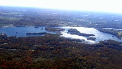
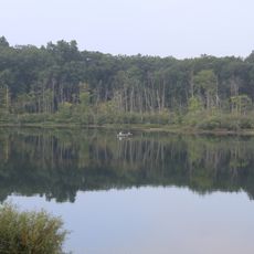
Kent Lake, reservoir lake in Oakland County, Michigan, USA

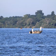
Kent Lake is a large reservoir in Michigan formed by damming the Huron River, spanning Oakland and Livingston counties within Kensington Metropark. The water body features wooded shores and open areas that accommodate fishing, boating, and waterside walks.

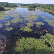
The lake was created in 1946 when a dam was built on the Huron River, enlarging a small natural lake into a major recreation area. The Huron-Clinton Metropolitan Authority managed this project to provide water storage and outdoor recreation for the region.

Kent Lake serves as a gathering spot for local families and outdoor enthusiasts throughout the year. People come to fish, boat, and enjoy quiet moments by the water, making it a valued part of the community's connection to nature.

The lake is accessible via straightforward roads with parking areas nearby where visitors can leave vehicles and walk to the water. A ten mile per hour speed limit for boats ensures safety for all users and keeps the environment calm.

The reservoir was originally a small natural lake of about 70 acres before the dam transformed it into a large recreation and water storage area. This change demonstrates how human infrastructure reshaped the landscape while creating new opportunities for nearby communities.

The community of curious travelers

AroundUs brings together thousands of curated places, local tips, and hidden gems, enriched daily by 60,000 contributors worldwide.

Start exploring
Location
Elevation above the sea
268 m
GPS coordinates
42.51983,-83.65254
Latest update
February 7, 2026 11:00
Around this place
Maybury State Park
United States of America

Maybury State Park

14 km
Highland Recreation Area
United States of America

Highland Recreation Area

14.5 km
Brighton Recreation Area
United States of America

Brighton Recreation Area

15.8 km
Proud Lake State Recreation Area
United States of America

Proud Lake State Recreation Area

10.2 km
Huron Meadows Metropark
United States of America

Huron Meadows Metropark

10.8 km
Northville Historic District
United States of America

Northville Historic District

17 km
St. Patrick's Parish Complex
United States of America

St. Patrick's Parish Complex

19.7 km
Nardin Park United Methodist Church
United States of America

Nardin Park United Methodist Church

15.4 km
Highland United Methodist Church
United States of America

Highland United Methodist Church

13.4 km
Detroit Finnish Co-operative Summer Camp
United States of America

Detroit Finnish Co-operative Summer Camp

11.5 km
Jacob and Rebecca Fuerst Farmstead
United States of America

Jacob and Rebecca Fuerst Farmstead

14.4 km
Andrews-Leggett House
United States of America

Andrews-Leggett House

15.7 km
Robert Yerkes House
United States of America

Robert Yerkes House

17.1 km
Nathan B. Devereaux Octagon House
United States of America

Nathan B. Devereaux Octagon House

10.8 km
Rowe House
United States of America

Rowe House

11.4 km
Western House
United States of America

Western House

11 km
Bingham House
United States of America

Bingham House

3.6 km
Joseph D. Yerkes House
United States of America

Joseph D. Yerkes House

17.9 km
Timothy and Lucretia Jones Warner Homestead
United States of America

Timothy and Lucretia Jones Warner Homestead

5.8 km
Dr. Henry K. Foote House
United States of America

Dr. Henry K. Foote House

8.4 km
Alonzo W. Olds House
United States of America

Alonzo W. Olds House

7.8 km
August Westphal Farmstead
United States of America

August Westphal Farmstead

14.1 km
North Milford Village Historic District
United States of America

North Milford Village Historic District

9.1 km
Hubbard-Kesby House
United States of America

Hubbard-Kesby House

5.1 km
Kittie C. McCoy House
United States of America

Kittie C. McCoy House

12.5 km
Kensington Metropark
United States of America

Kensington Metropark

2.4 km
Chilson Impoundment
United States of America

Chilson Impoundment

17.2 km
Spanish American War Regiments Historical Marker
United States of America

Spanish American War Regiments Historical Marker

7.1 km
Show the full map
« Kent Lake - reservoir lake in Oakland County, Michigan, USA » is provided by Around Us (aroundus.com). Images and texts are derived from Wikimedia project under a Creative Commons license. You are allowed to copy, distribute, and modify copies of this page, under the conditions set by the license, as long as this note is clearly visible.

Discover hidden gems everywhere you go!

From secret cafés to breathtaking viewpoints, skip the crowded tourist spots and find places that match your style. Our app makes it easy with voice search, smart filtering, route optimization, and insider tips from travelers worldwide. Download now for the complete mobile experience.

Around Us App Screenshot

A unique approach to discovering new places

Le Figaro

All the places worth exploring

France Info

A tailor-made excursion in just a few clicks

20 Minutes

Around Us
Travel Guide & Maps
Download

Send to your phone

QR Code
1

Open the camera app on your mobile.

2

Point at the QR code with your camera. A notification will appear.

3

Tap the notification to open the link.