Chest opened
+${chestReward.xp} XP
Explorer
NOUVEAU ×${chestReward.collectible.quantity}
tapez pour fermer
Chest locked

Open chests in the app

Around Us is built for your phone — chests unlock when you walk, explore and capture nearby places.

Enable Location

We need your location to show you interesting places around you

Discover nearby places

Find interesting locations and hidden gems around you

Precise directions

Get accurate directions and distances to places

Your location is never shared with other users. It's only used when you tap the location button.

Log in to your account

Start exploring — it's free

Trusted by 72,982 travelers worldwide

Continue with Google
Continue with Apple
or

We will send you a code to connect

By continuing, you accept our Terms and Conditions and our Privacy Policy

Check your inbox

We've sent a pincode in your inbox. Please enter the code below.

Cruces Basin Wilderness
Discussion Reviews Photo
2k Popularity

Cruces Basin Wilderness, Protected wilderness area in Rio Arriba County, New Mexico.

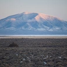
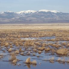
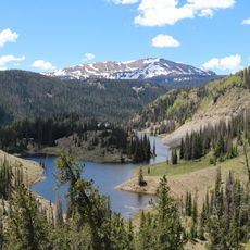
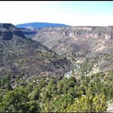
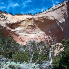
Cruces Basin Wilderness covers a large natural area with alpine lakes, meadows, and mountain peaks rising to significant elevations. The landscape shifts between open highlands and dense forests, offering hikers varied terrain and views.

Congress designated this area as protected wilderness in 1980 through federal legislation, placing it within the national preservation system. This designation meant the land would remain undeveloped and managed to keep its natural character.

The land served as hunting and gathering grounds for Indigenous peoples who lived off its resources for generations. This heritage remains visible in local place names and the way the landscape is understood by nearby communities.

Several marked trails with varying difficulty levels provide different entry points into the wilderness area. Visitors should prepare for changing weather at higher elevations and bring sturdy footwear for uneven terrain.

A forest fire in 1979 reshaped the landscape by clearing old growth, making room for new vegetation types that define the area today. Visitors now encounter aspen forests and high meadows where dense older forest once stood.

The community of curious travelers

AroundUs brings together thousands of curated places, local tips, and hidden gems, enriched daily by 60,000 contributors worldwide.

Start exploring
GPS coordinates
36.93263,-106.30511
Latest update
December 14, 2025 09:40
Around this place
Ghost Ranch
United States of America

Ghost Ranch

68.8 km
Cumbres and Toltec Scenic Railroad
United States of America

Cumbres and Toltec Scenic Railroad

25 km
Rio Grande Scenic Railroad
United States of America

Rio Grande Scenic Railroad

71.1 km
Monastery of Christ in the Desert
United States of America

Monastery of Christ in the Desert

70.2 km
Rio Grande del Norte National Monument
United States of America

Rio Grande del Norte National Monument

61.5 km
Cumbres Pass
United States of America

Cumbres Pass

16.2 km
San Antonio Mountain
United States of America

San Antonio Mountain

26.7 km
D&RGW 463
United States of America

D&RGW 463

24.5 km
John Dunn Bridge
United States of America

John Dunn Bridge

69.2 km
Monte Vista National Wildlife Refuge
United States of America

Monte Vista National Wildlife Refuge

64.1 km
Alamosa National Wildlife Refuge
United States of America

Alamosa National Wildlife Refuge

70.8 km
Conejos Peak
United States of America

Conejos Peak

46.1 km
Wild Rivers Recreation Area
United States of America

Wild Rivers Recreation Area

63 km
United States of America

Bennett Peak

62.4 km
Pike's Stockade
United States of America

Pike's Stockade

59.6 km
D&RGW 169
United States of America

D&RGW 169

71.5 km
United States of America

San Luis Hills

56.4 km
United States of America

Terrace Reservoir

47.9 km
St. Thomas Episcopal Church
United States of America

St. Thomas Episcopal Church

71.3 km
American National Bank Building
United States of America

American National Bank Building

71.3 km
Fort Lowell
United States of America

Fort Lowell

32.4 km
Samuel Sanchez House
United States of America

Samuel Sanchez House

29.3 km
Palace Hotel
United States of America

Palace Hotel

30.9 km
Alamosa County Courthouse
United States of America

Alamosa County Courthouse

71.2 km
Husung Hardware
United States of America

Husung Hardware

71.2 km
Gilbert Martinez Barn
United States of America

Gilbert Martinez Barn

33.9 km
Sanchez-March House
United States of America

Sanchez-March House

31.9 km
Echo amphitheatre
United States of America

Echo amphitheatre

66.8 km
Show the full map
Reviews
Share your experience

No review yet

Discussions
Start a discussion...

No discussion yet

« Cruces Basin Wilderness - Protected wilderness area in Rio Arriba County, New Mexico » is provided by Around Us (aroundus.com). Images and texts are derived from Wikimedia project under a Creative Commons license. You are allowed to copy, distribute, and modify copies of this page, under the conditions set by the license, as long as this note is clearly visible.

Discover hidden gems everywhere you go!

From secret cafés to breathtaking viewpoints, skip the crowded tourist spots and find places that match your style. Our app makes it easy with voice search, smart filtering, route optimization, and insider tips from travelers worldwide. Download now for the complete mobile experience.

Around Us App Screenshot

A unique approach to discovering new places

Le Figaro

All the places worth exploring

France Info

A tailor-made excursion in just a few clicks

20 Minutes

Around Us
Travel Guide & Maps
Download

Send to your phone

QR Code
1

Open the camera app on your mobile.

2

Point at the QR code with your camera. A notification will appear.

3

Tap the notification to open the link.