Chest opened
+${chestReward.xp} XP
Explorer
NOUVEAU ×${chestReward.collectible.quantity}
tapez pour fermer
Chest locked

Open chests in the app

Around Us is built for your phone — chests unlock when you walk, explore and capture nearby places.

Enable Location

We need your location to show you interesting places around you

Discover nearby places

Find interesting locations and hidden gems around you

Precise directions

Get accurate directions and distances to places

Your location is never shared with other users. It's only used when you tap the location button.

Log in to your account

Start exploring — it's free

Trusted by 72,979 travelers worldwide

Continue with Google
Continue with Apple
or

We will send you a code to connect

By continuing, you accept our Terms and Conditions and our Privacy Policy

Check your inbox

We've sent a pincode in your inbox. Please enter the code below.

Whisker Lake Wilderness
Discussion Reviews Photo
1.5k Popularity

Whisker Lake Wilderness, Protected wilderness area in Chequamegon National Forest, Wisconsin, US.

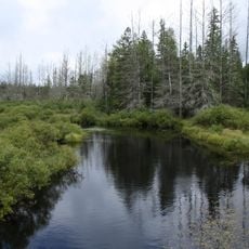
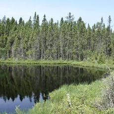
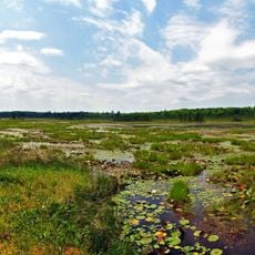
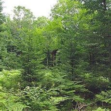
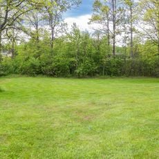
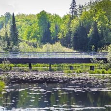
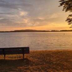
Whisker Lake Wilderness is a protected natural area in Chequamegon National Forest in Wisconsin spanning about 7500 acres. It contains six lakes, three streams, and the Brule River along its northern edge, with rolling hills and wetland areas throughout.

The area received federal protection in 1978 through Public Law 95-494, signed by President Carter. This action secured its natural character for future generations.

The name comes from mature pine trees along Whisker Lake's shore that local residents called chin whiskers in the early 1900s. These trees still shape how people experience the landscape today.

You can reach the area via State Highway 70 and forest road 2150; maps are available at Florence Natural Resources Center. Getting a map before visiting helps you navigate the expansive terrain.

The old pine trees near the lake survived both logging operations and wildfires that affected the surrounding region in the early 1900s. These survivors stand as silent witnesses to a turbulent past.

The community of curious travelers

AroundUs brings together thousands of curated places, local tips, and hidden gems, enriched daily by 60,000 contributors worldwide.

Start exploring
GPS coordinates
45.95111,-88.45500
Latest update
December 14, 2025 14:41
Around this place
Iron County MRA
United States of America

Iron County MRA

16.9 km
Chapin Mine Steam Pump Engine
United States of America

Chapin Mine Steam Pump Engine

33 km
Bewabic State Park
United States of America

Bewabic State Park

15.6 km
Lake Ellen Kimberlite
United States of America

Lake Ellen Kimberlite

32.9 km
Headwaters Wilderness
United States of America

Headwaters Wilderness

41.3 km
United States of America

Lumberjack Steam Train

46.8 km
Blackjack Springs Wilderness
United States of America

Blackjack Springs Wilderness

49 km
Iron Mountain Central Historic District
United States of America

Iron Mountain Central Historic District

33.5 km
Crystal Falls Dam and Power Plant
United States of America

Crystal Falls Dam and Power Plant

19.6 km
Camp Five Museum
United States of America

Camp Five Museum

46.4 km
Upper Twin Falls Bridge
United States of America

Upper Twin Falls Bridge

30.3 km
Central School
United States of America

Central School

21.4 km
Dickinson County Courthouse and Jail
United States of America

Dickinson County Courthouse and Jail

33.9 km
Ardis Furnace
United States of America

Ardis Furnace

33.7 km
Grandma Lake Wetlands State Natural Area
United States of America

Grandma Lake Wetlands State Natural Area

19.3 km
Franklin Lake Campground
United States of America

Franklin Lake Campground

41.7 km
Florence County Courthouse and Jail
United States of America

Florence County Courthouse and Jail

16.3 km
Iron County Courthouse
United States of America

Iron County Courthouse

18.7 km
Armstrong Creek Bridge
United States of America

Armstrong Creek Bridge

34.5 km
Forest Route 157–Tamarack River Bridge
United States of America

Forest Route 157–Tamarack River Bridge

52.1 km
Iron Mountain Iron Mine
United States of America

Iron Mountain Iron Mine

49.5 km
Anvil Lake Campground Shelter
United States of America

Anvil Lake Campground Shelter

46.9 km
Bose Lake Hemlock Hardwoods
United States of America

Bose Lake Hemlock Hardwoods

40.1 km
Fern School
United States of America

Fern School

13.9 km
Menominee River Park Archeological District
United States of America

Menominee River Park Archeological District

33.8 km
Chicagon Mine Road–Chicagon Creek Bridge
United States of America

Chicagon Mine Road–Chicagon Creek Bridge

16.6 km
Lake Antoine Beach
United States of America

Lake Antoine Beach

36 km
Lumberjack Steam Train & Camp 5 Museum
United States of America

Lumberjack Steam Train & Camp 5 Museum

46.8 km
Show the full map
Reviews
Share your experience

No review yet

Discussions
Start a discussion...

No discussion yet

« Whisker Lake Wilderness - Protected wilderness area in Chequamegon National Forest, Wisconsin, US » is provided by Around Us (aroundus.com). Images and texts are derived from Wikimedia project under a Creative Commons license. You are allowed to copy, distribute, and modify copies of this page, under the conditions set by the license, as long as this note is clearly visible.

Discover hidden gems everywhere you go!

From secret cafés to breathtaking viewpoints, skip the crowded tourist spots and find places that match your style. Our app makes it easy with voice search, smart filtering, route optimization, and insider tips from travelers worldwide. Download now for the complete mobile experience.

Around Us App Screenshot

A unique approach to discovering new places

Le Figaro

All the places worth exploring

France Info

A tailor-made excursion in just a few clicks

20 Minutes

Around Us
Travel Guide & Maps
Download

Send to your phone

QR Code
1

Open the camera app on your mobile.

2

Point at the QR code with your camera. A notification will appear.

3

Tap the notification to open the link.