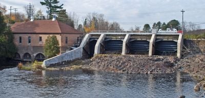
Crystal Falls Dam and Power Plant, Hydroelectric power station in Crystal Falls, Michigan
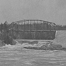
Crystal Falls Dam and Power Plant is a hydroelectric facility on the Paint River in Michigan that converts flowing water into electricity using engineered spillways and a concrete dam structure. Yellow brick buildings house the machinery and equipment needed to manage the water flow and generate power for the community.
The facility was built in 1891 to harness the natural waterfalls that originally inspired the town's name. Subsequent expansions strengthened its capacity to serve the growing community's energy needs as the region developed.
The power plant stands as a recognized local landmark, with its distinctive yellow brick buildings reflecting the community's industrial heritage and engineering pride. Visitors can observe how the facility has shaped the identity of the town and its relationship with the river that powered its growth.
The site sits along the Paint River and is visible from public areas near downtown Crystal Falls, making it easy to view from outside. Since this is an active power station, access to the machinery and internal areas is restricted for safety reasons, but the exterior and overall structure can be observed from designated viewing areas.
This is one of Michigan's Upper Peninsula longest-operating hydroelectric facilities, running continuously since the 1800s without interruption. Its enduring operation demonstrates how well the original engineering was designed and how it adapted to serve generations of power needs.
The community of curious travelers
AroundUs brings together thousands of curated places, local tips, and hidden gems, enriched daily by 60,000 contributors worldwide.