Upper Twin Falls Bridge, Road bridge in Breitung Township, United States.
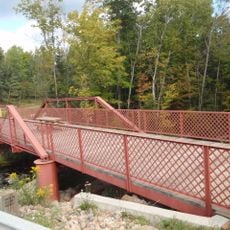
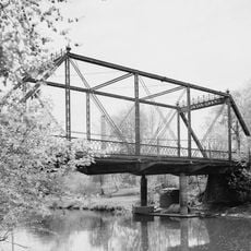
The Upper Twin Falls Bridge is a road bridge that crosses the Menominee River, connecting Breitung Township in Michigan with Florence County in Wisconsin through a single-span design. The structure features a camelback through-truss design with pin connections.
The bridge was built in 1910 to support the development of a downstream dam, with both counties sharing the cost. It remained open to vehicle traffic until September 1971, when authorities closed it and transferred ownership to the Dickinson County Road Commission.
The monument at the north end honors Gilbert Carpenter, who oversaw the construction and later died in World War I. This location reflects how two states worked together on shared infrastructure during the region's industrial development.
Since the bridge has been closed to vehicle traffic since 1971, visitors can only explore it on foot and view the structure from above. The best time to visit is outside winter months, when snow and ice do not interfere with access.
The bridge spans the river about 4 miles north of Iron Mountain and is one of the few remaining examples of camelback through-truss design with pin connections in the region. This specific connection system was an advanced construction method used on only a handful of bridges during the early 1900s.
Location: Breitung Township
Location: Florence
Inception: 1910s
GPS coordinates: 45.87750,-88.07850
Latest update: December 14, 2025 16:41
Iron County MRA
40.9 km
Chapin Mine Steam Pump Engine
5.9 km
Governor Thompson State Park
61.9 kmDave's Falls
43 km
Bewabic State Park
36.2 km
Lake Ellen Kimberlite
33.9 kmLumberjack Steam Train
58.7 km
Iron Mountain Central Historic District
6.5 km
Peshtigo River State Forest
66.1 km
IXL Historical Museum
41.1 km
Camp Five Museum
59.2 km
Central School
49.7 km
Dickinson County Courthouse and Jail
6.8 km
Ardis Furnace
4.9 km
Grandma Lake Wetlands State Natural Area
42 km
Florence County Courthouse and Jail
14.1 km
Iron County Courthouse
31.5 km
Armstrong Creek Bridge
38.8 km
County Road 557–West Branch Escanaba River Bridge
56.3 km
Iron Mountain Iron Mine
19.7 km
Fern School
24.3 km
Menominee River Park Archeological District
10.5 km
Chicago and North-Western Land Office
66.6 km
Grand Avenue Bridge
46 km
Chicagon Mine Road–Chicagon Creek Bridge
41.2 km
Lumberjack Steam Train & Camp 5 Museum
58.7 km
World War II Glider and Military Museum
5.9 km
M 189 / W 139 Highway Bridge over Brule River
46.1 kmVisited this place? Tap the stars to rate it and share your experience / photos with the community! Try now! You can cancel it anytime.
Discover hidden gems everywhere you go!
From secret cafés to breathtaking viewpoints, skip the crowded tourist spots and find places that match your style. Our app makes it easy with voice search, smart filtering, route optimization, and insider tips from travelers worldwide. Download now for the complete mobile experience.
A unique approach to discovering new places❞
— Le Figaro
All the places worth exploring❞
— France Info
A tailor-made excursion in just a few clicks❞
— 20 Minutes