Log in to your account

AroundUs is a community-driven map of interesting places, built by curious explorers like you. It grows with every review, story, and photo you share.
Connect to save your favorite spots, contribute locations, and create personalized routes.
Continue with Google
Continue with Apple
Continue with X
Continue with Facebook
Continue with email
By continuing, you accept our Terms and Conditions and our Privacy Policy
Create an account

Little Wilson Creek Wilderness

Add to collection
Map
Suggest a change
Share

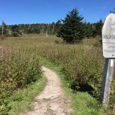
Little Wilson Creek Wilderness, Protected wilderness area in Grayson County, Virginia, US.

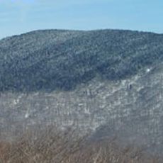
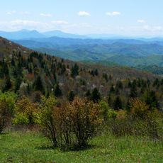
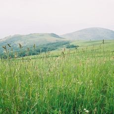
Little Wilson Creek Wilderness is a protected mountain area within Mount Rogers National Recreation Area, with elevations rising between 3,220 and 4,857 feet. Dense forests and ridgelines shape the terrain, with trails running through valleys and along slopes.

This area was protected in 1984 through the Virginia Wilderness Act and gained additional safeguards under the 2009 Omnibus Public Land Management Act. The dual protection reflects growing recognition of the need to preserve mountain ecosystems.

Backpackers pass through this area as part of their long-distance journeys, particularly on the Appalachian Trail, where mountain sections offer both challenge and solitude. The remote character makes it meaningful to those seeking to step away from crowds and noise.

Paper maps are essential since cellular coverage does not reach into the area and dense forest sections can make navigation difficult. Visitors should prepare for extended hikes and bring sturdy footwear along with weather-appropriate clothing.

The forests combine northern and southern tree species, with sugar maple and beech at lower elevations and red spruce plus Fraser fir on higher slopes. This botanical mix results from the location's position along the Appalachian mountain chain.

GPS coordinates: 36.65250,-81.46500

Latest update: December 14, 2025 18:41

Photos
Around this place
Mount Rogers
United States of America

Mount Rogers

7.2 km
Grayson Highlands State Park
United States of America

Grayson Highlands State Park

5.1 km
United States of America

North Carolina–Tennessee–Virginia Corners

20.3 km
Whitetop Mountain
United States of America

Whitetop Mountain

12.6 km
Lincoln Theatre
United States of America

Lincoln Theatre

20.7 km
Preston House
United States of America

Preston House

21.8 km
Abijah Thomas House
United States of America

Abijah Thomas House

16.5 km
Ripshin Farm
United States of America

Ripshin Farm

7.2 km
Lewis Fork Wilderness
United States of America

Lewis Fork Wilderness

7.2 km
United States of America

Mount Rogers Cluster

7.1 km
United States of America

Whitetop Mountain

12.7 km
Smyth County Community Hospital
United States of America

Smyth County Community Hospital

22.7 km
United States of America

Whitetop Laurel

21.8 km
Brookside Farm and Mill
United States of America

Brookside Farm and Mill

21.7 km
Mount Rogers Crest Zone
United States of America

Mount Rogers Crest Zone

3.3 km
Konnarock Training School
United States of America

Konnarock Training School

13.2 km
Henderson Building
United States of America

Henderson Building

20.6 km
Ashe Metamorphic Suite
United States of America

Ashe Metamorphic Suite

18.8 km
Marion Historic District (Marion, Virginia)
United States of America

Marion Historic District (Marion, Virginia)

20.6 km
Worth's Chapel
United States of America

Worth's Chapel

25.1 km
Samuel Cox House
United States of America

Samuel Cox House

24 km
H.L. Bonham House
United States of America

H.L. Bonham House

25 km
William Waddell House
United States of America

William Waddell House

9.6 km
Marion Male Academy
United States of America

Marion Male Academy

20.6 km
William Weaver House
United States of America

William Weaver House

20.8 km
Bower-Cox House
United States of America

Bower-Cox House

24.8 km
John W. Tucker House
United States of America

John W. Tucker House

16.6 km
John M. Pierce House
United States of America

John M. Pierce House

17 km
Show the full map
Reviews

Visited this place? Tap the stars to rate it and share your experience / photos with the community! Try now! You can cancel it anytime.

« Little Wilson Creek Wilderness - Protected wilderness area in Grayson County, Virginia, US » is provided by Around Us (aroundus.com). Images and texts are derived from Wikimedia project under a Creative Commons license. You are allowed to copy, distribute, and modify copies of this page, under the conditions set by the license, as long as this note is clearly visible.

Discover hidden gems everywhere you go!

From secret cafés to breathtaking viewpoints, skip the crowded tourist spots and find places that match your style. Our app makes it easy with voice search, smart filtering, route optimization, and insider tips from travelers worldwide. Download now for the complete mobile experience.

Around Us App Screenshot

A unique approach to discovering new places

Le Figaro

All the places worth exploring

France Info

A tailor-made excursion in just a few clicks

20 Minutes