Jacob Lake Lookout Tower

Log in to your account

AroundUs is a community-driven map of interesting places, built by curious explorers like you. It grows with every review, story, and photo you share.
Connect to save your favorite spots, contribute locations, and create personalized routes.
Continue with Google
Continue with Apple
Continue with X
Continue with Facebook
Continue with email
By continuing, you accept our Terms and Conditions and our Privacy Policy
Create an account
Add to collection
Map
Suggest a change
Share

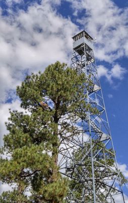
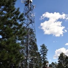
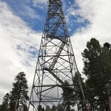
Jacob Lake Lookout Tower, Fire lookout tower in Coconino County, Arizona

Jacob Lake Lookout Tower is a steel fire observation tower in Coconino County that rises 80 feet (24 meters) into the sky with a 7-by-7-foot (2-by-2-meter) metal observation cab at the top. The structure was designed to give watchers a wide view of the surrounding northern Arizona forest and landscape from that elevated vantage point.

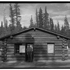
This structure was built in 1934 by the U.S. Forest Service using contractors from Kanab as part of a regional wildfire detection network. It marked a shift in fire management when authorities moved from moving patrols on horseback to fixed observation posts stationed across the landscape.

The structure represents the advancement of forest protection methods, transitioning from horseback patrols to permanent observation points in the American Southwest.

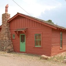
The tower sits at an elevation of 8,130 feet and can be reached via Arizona Route 67, roughly 1.2 kilometers south of U.S. Route 89A. Visitors should know that the location is remote, so plan to arrive with proper preparation and allow enough time to explore the area.

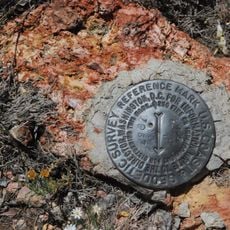
The tower still houses its original Osborne Fire Finder equipment, a specialized tool that forest rangers used to pinpoint the exact location of smoke columns in the distance. This device reveals how fire detection worked before modern technology and the skill required to use it effectively.

Location: Coconino County

Inception: 1934

Made from material: steel

GPS coordinates: 36.69979,-112.21367

Latest update: December 14, 2025 18:02

Photos
Around this place
The Wave
United States of America

The Wave

37.8 km
Buckskin Gulch
United States of America

Buckskin Gulch

45.7 km
United States of America

Paria Canyon-Vermilion Cliffs Wilderness

40.8 km
Pipe Spring National Monument
United States of America

Pipe Spring National Monument

50.3 km
Wire Pass Trailhead
United States of America

Wire Pass Trailhead

39.3 km
Kanab Creek Wilderness
United States of America

Kanab Creek Wilderness

35.1 km
Wrather Arch
United States of America

Wrather Arch

48.4 km
Holy Grail Temple
United States of America

Holy Grail Temple

48 km
Kanab Creek Trail
United States of America

Kanab Creek Trail

50.6 km
North Bass Trail
United States of America

North Bass Trail

42.2 km
Kanab Lodge
United States of America

Kanab Lodge

47.9 km
Big Springs Lookout Tower
United States of America

Big Springs Lookout Tower

16 km
Brow Monument and Brow Monument Trail
United States of America

Brow Monument and Brow Monument Trail

20.5 km
Masonic Temple
United States of America

Masonic Temple

48.7 km
Jacob Lake Ranger Station
United States of America

Jacob Lake Ranger Station

1.5 km
Big Springs Ranger Station
United States of America

Big Springs Ranger Station

16.2 km
Rider-Pugh House
United States of America

Rider-Pugh House

47.7 km
Bowman-Chamberlain House
United States of America

Bowman-Chamberlain House

47.6 km
Chuckwagon Cookout
United States of America

Chuckwagon Cookout

48.1 km
William Derby Johnson, Jr., House
United States of America

William Derby Johnson, Jr., House

47.7 km
Stewart-Woolley House
United States of America

Stewart-Woolley House

48.1 km
North Rim Entrance Station
United States of America

North Rim Entrance Station

41.5 km
White Pocket
United States of America

White Pocket

39.7 km
Cameron's Hotel
United States of America

Cameron's Hotel

35 km
Edmaier's Secret
United States of America

Edmaier's Secret

43.1 km
Dry Park Lookout
United States of America

Dry Park Lookout

27.6 km
Pipe Spring National Monument Visitor Center
United States of America

Pipe Spring National Monument Visitor Center

50.1 km
Wire Pass
United States of America

Wire Pass

40.1 km
Show the full map
Reviews

Visited this place? Tap the stars to rate it and share your experience / photos with the community! Try now! You can cancel it anytime.

« Jacob Lake Lookout Tower - Fire lookout tower in Coconino County, Arizona » is provided by Around Us (aroundus.com). Images and texts are derived from Wikimedia project under a Creative Commons license. You are allowed to copy, distribute, and modify copies of this page, under the conditions set by the license, as long as this note is clearly visible.

Discover hidden gems everywhere you go!

From secret cafés to breathtaking viewpoints, skip the crowded tourist spots and find places that match your style. Our app makes it easy with voice search, smart filtering, route optimization, and insider tips from travelers worldwide. Download now for the complete mobile experience.

Around Us App Screenshot

A unique approach to discovering new places

Le Figaro

All the places worth exploring

France Info

A tailor-made excursion in just a few clicks

20 Minutes