Enable Location

We need your location to show you interesting places around you

Discover nearby places

Find interesting locations and hidden gems around you

Precise directions

Get accurate directions and distances to places

Your location is never shared with other users. It's only used when you tap the location button.

Kanab Creek Wilderness

Log in to your account

Start exploring — it's free

Trusted by travelers worldwide

Continue with Google
Continue with Apple
or

We will send you a code to connect

By continuing, you accept our Terms and Conditions and our Privacy Policy

Check your inbox

We've sent a pincode in your inbox. Please enter the code below.

Kanab Creek Wilderness

Kanab Creek Wilderness, Protected wilderness area in Coconino County, Arizona.

Description

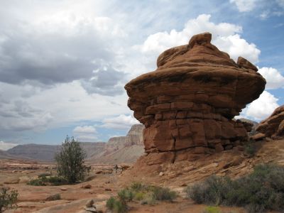
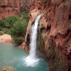
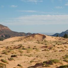
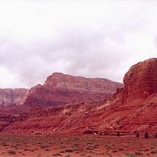
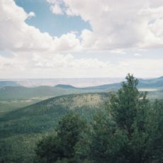
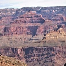
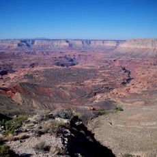
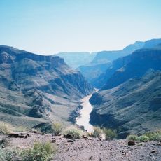
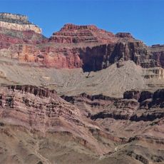
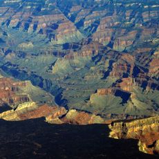
Kanab Creek Wilderness is a protected area in Arizona featuring a network of gorges with steep rock walls cutting through plateaus. The canyon system includes multiple waterways that flow through dramatic terrain shaped by millions of years of erosion.

History

The area received official protection in 1984 through the Arizona Wilderness Act, establishing joint management between the Forest Service and Bureau of Land Management. This designation came as part of a broader effort to preserve wild lands across the western United States.

Culture

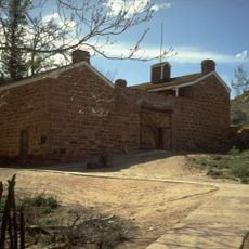
Rock art panels visible on canyon walls reveal how indigenous peoples marked this landscape long ago. These carvings and paintings show connections to the communities who once lived across this region.

Practical

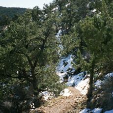
Bring sturdy hiking boots and plenty of water, as trails are challenging and shade is limited throughout the area. Spring and fall offer the most comfortable conditions for visiting this remote wilderness.

Did you know?

This wilderness holds one of the most significant tributary canyon systems on the north side of the Grand Canyon. Few visitors realize that pronghorn antelope and mule deer roam through these remote valleys, adding to the area's wild character.

Location
GPS coordinates
36.56530,-112.56900
Latest update
December 12, 2025 14:24

AroundUs brings together thousands of curated places, local tips, and hidden gems, enriched daily by 60,000 contributors worldwide. Discover all places nearby (Arizona).

Around this place
Havasu Falls
United States of America

Havasu Falls

36.4 km
Coral Pink Sand Dunes State Park
United States of America

Coral Pink Sand Dunes State Park

54.3 km
Vermilion Cliffs
United States of America

Vermilion Cliffs

46.9 km
Pipe Spring National Monument
United States of America

Pipe Spring National Monument

36.5 km
Mount Trumbull Wilderness
United States of America

Mount Trumbull Wilderness

53 km
Holy Grail Temple
United States of America

Holy Grail Temple

40.1 km
Big House
United States of America

Big House

41.9 km
Kanab Creek Trail
United States of America

Kanab Creek Trail

20 km
South Bass Trail
United States of America

South Bass Trail

45.8 km
Royal Arch Route
United States of America

Royal Arch Route

43.1 km
North Bass Trail
United States of America

North Bass Trail

32.3 km
Jacob Lake Lookout Tower
United States of America

Jacob Lake Lookout Tower

35.1 km
Kanab Lodge
United States of America

Kanab Lodge

53.7 km
Big Springs Lookout Tower
United States of America

Big Springs Lookout Tower

21.2 km
Brow Monument and Brow Monument Trail
United States of America

Brow Monument and Brow Monument Trail

15.5 km
Masonic Temple
United States of America

Masonic Temple

38 km
Tuna Canyon
United States of America

Tuna Canyon

49.8 km
Jacob Lake Ranger Station
United States of America

Jacob Lake Ranger Station

34.3 km
Big Springs Ranger Station
United States of America

Big Springs Ranger Station

20.1 km
Rider-Pugh House
United States of America

Rider-Pugh House

53.7 km
Bowman-Chamberlain House
United States of America

Bowman-Chamberlain House

53.7 km
Chuckwagon Cookout
United States of America

Chuckwagon Cookout

53.8 km
William Derby Johnson, Jr., House
United States of America

William Derby Johnson, Jr., House

53.7 km
Stewart-Woolley House
United States of America

Stewart-Woolley House

54.1 km
North Rim Entrance Station
United States of America

North Rim Entrance Station

48 km
Cameron's Hotel
United States of America

Cameron's Hotel

42.8 km
Dry Park Lookout
United States of America

Dry Park Lookout

32.1 km
Pipe Spring National Monument Visitor Center
United States of America

Pipe Spring National Monument Visitor Center

36.3 km
Show the full map
« Kanab Creek Wilderness - Protected wilderness area in Coconino County, Arizona » is provided by Around Us (aroundus.com). Images and texts are derived from Wikimedia project under a Creative Commons license. You are allowed to copy, distribute, and modify copies of this page, under the conditions set by the license, as long as this note is clearly visible.

Discover hidden gems everywhere you go!

From secret cafés to breathtaking viewpoints, skip the crowded tourist spots and find places that match your style. Our app makes it easy with voice search, smart filtering, route optimization, and insider tips from travelers worldwide. Download now for the complete mobile experience.

Around Us App Screenshot

A unique approach to discovering new places

Le Figaro

All the places worth exploring

France Info

A tailor-made excursion in just a few clicks

20 Minutes

Around Us
Travel Guide & Maps
Download

Send to your phone

QR Code
1

Open the camera app on your mobile.

2

Point at the QR code with your camera. A notification will appear.

3

Tap the notification to open the link.