Enable Location

We need your location to show you interesting places around you

Discover nearby places

Find interesting locations and hidden gems around you

Precise directions

Get accurate directions and distances to places

Your location is never shared with other users. It's only used when you tap the location button.

Log in to your account

Start exploring — it's free

Trusted by 63,190 travelers worldwide

Continue with Google
Continue with Apple
or

We will send you a code to connect

By continuing, you accept our Terms and Conditions and our Privacy Policy

Check your inbox

We've sent a pincode in your inbox. Please enter the code below.

D.A.R. State Park
Discussion Reviews Photo
1.1k Popularity

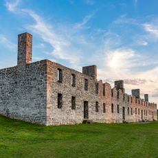
D.A.R. State Park, State park in Addison County, Vermont

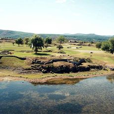
D.A.R. State Park is a campground and day-use area in Vermont situated directly on Lake Champlain. The facility offers about 46 tent and RV sites, 24 lean-to shelters, and basic amenities including two bathhouses with flush toilets and showers, while the shoreline features naturally flat shale and stone that slopes gently toward the water.

The park was established as a memorial by the Daughters of the American Revolution organization, giving it a patriotic historical foundation. Its creation reflects the early-to-mid 20th century movement to establish public campgrounds and recreation areas across Vermont and the region.

The park sits along Lake Champlain and reflects how locals and visitors use this shoreline for outdoor relaxation and family gatherings. Stone and shale areas create informal gathering spots where people naturally collect to watch the water and share meals together.

The park operates from late May through Labor Day and welcomes visitors from 10 AM until sunset, with separate seasons for day-use and overnight camping. Water shoes are helpful along the rocky shore, and bring quarters if you plan to use the showers, which are a paid convenience.

The shoreline is covered with flat shale and naturally smooth stones that are ideal for skipping, offering visitors a playful and tactile experience rarely found at other lakes. This natural stone formation creates informal gathering spots where children and adults naturally gravitate toward the water.

The community of curious travelers

AroundUs brings together thousands of curated places, local tips, and hidden gems, enriched daily by 60,000 contributors worldwide.

Start exploring
Location
Inception
1955
GPS coordinates
44.05340,-73.41230
Latest update
February 9, 2026 07:43
Around this place
Fort Crown Point
United States of America

Fort Crown Point

3.1 km
Lake Champlain Bridge
United States of America

Lake Champlain Bridge

2.5 km
Lake Champlain Bridge
United States of America

Lake Champlain Bridge

2.5 km
Snake Mountain
United States of America

Snake Mountain

10.6 km
Fort Saint-Frédéric
United States of America

Fort Saint-Frédéric

3.1 km
Crown Point Light
United States of America

Crown Point Light

2.7 km
Grand Isle State Park
United States of America

Grand Isle State Park

15.3 km
Barber's Point Light
United States of America

Barber's Point Light

11.3 km
Essex County Fairgrounds
United States of America

Essex County Fairgrounds

15.1 km
Champlain II
United States of America

Champlain II

17.2 km
John Strong Mansion Museum
United States of America

John Strong Mansion Museum

150 m
Addison Baptist Church
United States of America

Addison Baptist Church

9.6 km
Wesleyan Methodist Church
United States of America

Wesleyan Methodist Church

15.8 km
Sherman Free Library
United States of America

Sherman Free Library

3.9 km
Gen. Samuel Strong House
United States of America

Gen. Samuel Strong House

17.4 km
Moriah Town Office Building
United States of America

Moriah Town Office Building

4 km
Bridge 26
United States of America

Bridge 26

17.6 km
Witherbee Memorial Hall
United States of America

Witherbee Memorial Hall

10 km
Camp Dudley Road Historic District
United States of America

Camp Dudley Road Historic District

11.2 km
Lake View Grange No. 970
United States of America

Lake View Grange No. 970

14.9 km
District Six Schoolhouse
United States of America

District Six Schoolhouse

16.5 km
Paris and Anna Fletcher House
United States of America

Paris and Anna Fletcher House

11 km
Samuel Paddock Strong House
United States of America

Samuel Paddock Strong House

17 km
Central Powerhouse
United States of America

Central Powerhouse

10.8 km
Cotton Free Library
United States of America

Cotton Free Library

15.8 km
District School No. 1
United States of America

District School No. 1

9 km
John Hamilton Farmstead
United States of America

John Hamilton Farmstead

13.1 km
Lake Champlain Maritime Museum
United States of America

Lake Champlain Maritime Museum

16.6 km
Show the full map
Reviews
Share your experience

No review yet

Discussions
Start a discussion...

No discussion yet

« D.A.R. State Park - State park in Addison County, Vermont » is provided by Around Us (aroundus.com). Images and texts are derived from Wikimedia project under a Creative Commons license. You are allowed to copy, distribute, and modify copies of this page, under the conditions set by the license, as long as this note is clearly visible.

Discover hidden gems everywhere you go!

From secret cafés to breathtaking viewpoints, skip the crowded tourist spots and find places that match your style. Our app makes it easy with voice search, smart filtering, route optimization, and insider tips from travelers worldwide. Download now for the complete mobile experience.

Around Us App Screenshot

A unique approach to discovering new places

Le Figaro

All the places worth exploring

France Info

A tailor-made excursion in just a few clicks

20 Minutes

Around Us
Travel Guide & Maps
Download

Send to your phone

QR Code
1

Open the camera app on your mobile.

2

Point at the QR code with your camera. A notification will appear.

3

Tap the notification to open the link.