Enable Location

We need your location to show you interesting places around you

Discover nearby places

Find interesting locations and hidden gems around you

Precise directions

Get accurate directions and distances to places

Your location is never shared with other users. It's only used when you tap the location button.

Log in to your account

Start exploring — it's free

Trusted by 62,983 travelers worldwide

Continue with Google
Continue with Apple
or

We will send you a code to connect

By continuing, you accept our Terms and Conditions and our Privacy Policy

Check your inbox

We've sent a pincode in your inbox. Please enter the code below.

Devil Canyon
Discussion Reviews Photo
1.4k Popularity

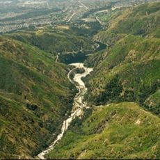
Devil Canyon, Canyon in San Bernardino Mountains, California, United States.

Devil Canyon is a canyon in the San Bernardino Mountains with steep rock walls and narrow passages carved by water erosion over time. The valley contains multiple streams that feed into the Santa Ana River system as they flow through the terrain.

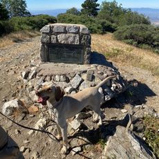
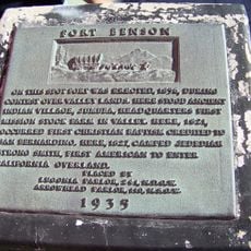
Early explorers and settlers used the canyon as a passage through the mountains during the period of European expansion and settlement. The route provided crucial access through difficult terrain for travel and commerce.

The canyon borders the Crow Indian Reservation, reflecting the continuous presence of Native American heritage in the surrounding territories.

The terrain is challenging and requires good hiking skills and proper equipment for mountain trekking. Visitors should prepare for changing weather conditions and bring adequate water and supplies.

Visitors can spot Bighorn Sheep at multiple locations throughout the canyon, a species native to this region. The animals use the steep cliffs as shelter and are often visible during early morning or late evening hours.

The community of curious travelers

AroundUs brings together thousands of curated places, local tips, and hidden gems, enriched daily by 60,000 contributors worldwide.

Start exploring
GPS coordinates
34.19694,-117.33750
Latest update
December 9, 2025 20:23
Around this place
Auto Club Speedway
United States of America

Auto Club Speedway

19.2 km
United States of America

Jurupa Oak

18.9 km
Glen Helen Amphitheater
United States of America

Glen Helen Amphitheater

6 km
Lake Arrowhead Reservoir
United States of America

Lake Arrowhead Reservoir

15.8 km
Santa's Village
United States of America

Santa's Village

15.5 km
Glen Helen Regional Park
United States of America

Glen Helen Regional Park

6.5 km
Bonita Falls
United States of America

Bonita Falls

15.8 km
Devil Canyon
United States of America

Devil Canyon

46 m
San Bernardino County Court House
United States of America

San Bernardino County Court House

11 km
Slover Mountain
United States of America

Slover Mountain

14.7 km
Barton Villa
United States of America

Barton Villa

19.9 km
Cajon Pass
United States of America

Cajon Pass

16.6 km
Santa Fe And Salt Lake Trail Monument
United States of America

Santa Fe And Salt Lake Trail Monument

17 km
First Christian Church of Rialto
United States of America

First Christian Church of Rialto

10.9 km
Colton Carnegie Library
United States of America

Colton Carnegie Library

14.3 km
Rosa Parks Memorial Building
United States of America

Rosa Parks Memorial Building

10.8 km
Monument Peak
United States of America

Monument Peak

5.6 km
Santos Manuel Student Union
United States of America

Santos Manuel Student Union

2.2 km
Norman F. Feldheym Library
United States of America

Norman F. Feldheym Library

10.5 km
Fort Benson
United States of America

Fort Benson

15.8 km
San Bernardino Valley Water Conservation Demonstration Garden
United States of America

San Bernardino Valley Water Conservation Demonstration Garden

2 km
Highland Historic District
United States of America

Highland Historic District

14.2 km
Fontana Farms Company Ranch House, Camp No. 1
United States of America

Fontana Farms Company Ranch House, Camp No. 1

15 km
Empire Bowl
United States of America

Empire Bowl

19.8 km
Aquatic Center
United States of America

Aquatic Center

12.7 km
San Dimas Experimental Forest
United States of America

San Dimas Experimental Forest

14.2 km
Arboreto Heaps Peak
United States of America

Arboreto Heaps Peak

18.6 km
San Bernardino History and Railroad Museum
United States of America

San Bernardino History and Railroad Museum

10.6 km
Show the full map
Reviews
Share your experience

No review yet

Discussions
Start a discussion...

No discussion yet

« Devil Canyon - Canyon in San Bernardino Mountains, California, United States » is provided by Around Us (aroundus.com). Images and texts are derived from Wikimedia project under a Creative Commons license. You are allowed to copy, distribute, and modify copies of this page, under the conditions set by the license, as long as this note is clearly visible.

Discover hidden gems everywhere you go!

From secret cafés to breathtaking viewpoints, skip the crowded tourist spots and find places that match your style. Our app makes it easy with voice search, smart filtering, route optimization, and insider tips from travelers worldwide. Download now for the complete mobile experience.

Around Us App Screenshot

A unique approach to discovering new places

Le Figaro

All the places worth exploring

France Info

A tailor-made excursion in just a few clicks

20 Minutes

Around Us
Travel Guide & Maps
Download

Send to your phone

QR Code
1

Open the camera app on your mobile.

2

Point at the QR code with your camera. A notification will appear.

3

Tap the notification to open the link.