Cajon Pass

Log in to your account

AroundUs is a community-driven map of interesting places, built by curious explorers like you. It grows with every review, story, and photo you share.
Connect to save your favorite spots, contribute locations, and create personalized routes.
By continuing, you accept our Terms and Conditions and our Privacy Policy
Add to collection
Map
Suggest a change
Share

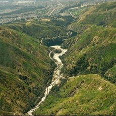
Cajon Pass, Road and rail mountain pass in San Bernardino County, United States.

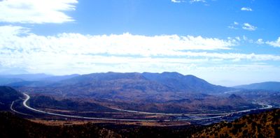
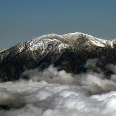
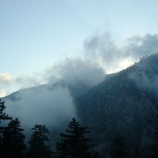
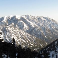
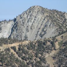
Cajon Pass is a mountain crossing between the San Bernardino Mountains and San Gabriel Mountains in Southern California, reaching an elevation of about 3,777 feet. The Interstate 15 and two major railway lines cut through the pass, forming a crucial transportation corridor that links Los Angeles with the High Desert region.

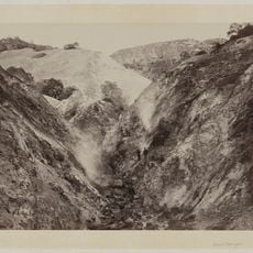
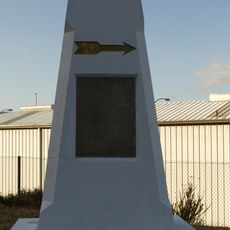
The first railroad through the pass was built in the 1880s by the California Southern Railroad, connecting Barstow to San Diego across challenging terrain. This rail line transformed transportation in the region and enabled faster movement of goods and people between coastal areas and inland destinations.

The pass carries a Spanish name meaning box or chest, a reference to how the narrow passage between the mountains appeared to early travelers. This naming reflects the route's long history as a crossing point used by different peoples moving through Southern California.

The pass is easily accessed via Interstate 15, which serves as the primary road connection through the area. Keep in mind that the terrain is mountainous and exposed, particularly during extreme weather conditions, so plan your visit accordingly.

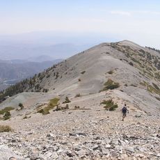
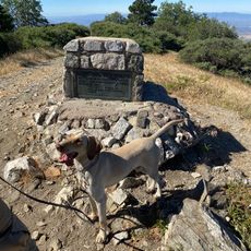
The Pacific Crest Trail crosses through the pass at a location where hikers encounter a McDonald's restaurant, an unexpected oasis of civilization in the middle of wilderness. This surprising intersection makes the spot a memorable moment for long-distance trail walkers.

Location: San Bernardino County

Elevation above the sea: 1,151 m

GPS coordinates: 34.32583,-117.42833

Latest update: December 14, 2025 14:22

Photos
Around this place
Mount San Antonio
United States of America

Mount San Antonio

20.5 km
Glen Helen Amphitheater
United States of America

Glen Helen Amphitheater

13.7 km
Deep Creek Hot Springs
United States of America

Deep Creek Hot Springs

23.2 km
Lake Arrowhead Reservoir
United States of America

Lake Arrowhead Reservoir

23.8 km
Cucamonga Peak
United States of America

Cucamonga Peak

18.4 km
Santa's Village
United States of America

Santa's Village

25.4 km
Lake Arrowhead Village Beach
United States of America

Lake Arrowhead Village Beach

23.5 km
Mount Baldy Zen Center
United States of America

Mount Baldy Zen Center

21.1 km
Glen Helen Regional Park
United States of America

Glen Helen Regional Park

13.6 km
Table Mountain Observatory
United States of America

Table Mountain Observatory

24.1 km
Bonita Falls
United States of America

Bonita Falls

12.7 km
Devil Canyon
United States of America

Devil Canyon

16.6 km
Ontario Peak
United States of America

Ontario Peak

21.1 km
Mount Harwood
United States of America

Mount Harwood

19.3 km
Victoria Gardens Cultural Center
United States of America

Victoria Gardens Cultural Center

25.6 km
Telegraph Peak
United States of America

Telegraph Peak

17.2 km
Santa Fe And Salt Lake Trail Monument
United States of America

Santa Fe And Salt Lake Trail Monument

4.1 km
First Christian Church of Rialto
United States of America

First Christian Church of Rialto

25.4 km
Monument Peak
United States of America

Monument Peak

11.3 km
Santos Manuel Student Union
United States of America

Santos Manuel Student Union

18.7 km
Mormon Trail Monument
United States of America

Mormon Trail Monument

9.5 km
San Bernardino Valley Water Conservation Demonstration Garden
United States of America

San Bernardino Valley Water Conservation Demonstration Garden

18.6 km
Fontana Farms Company Ranch House, Camp No. 1
United States of America

Fontana Farms Company Ranch House, Camp No. 1

26 km
Aquatic Center
United States of America

Aquatic Center

19.6 km
San Dimas Experimental Forest
United States of America

San Dimas Experimental Forest

23.1 km
Mountain History Museum
United States of America

Mountain History Museum

21.3 km
Tavern Bay Beach
United States of America

Tavern Bay Beach

23.3 km
Hamiltair community Beach
United States of America

Hamiltair community Beach

22.7 km
Show the full map
Reviews

Visited this place? Tap the stars to rate it and share your experience / photos with the community! Try now! You can cancel it anytime.

« Cajon Pass - Road and rail mountain pass in San Bernardino County, United States » is provided by Around Us (aroundus.com). Images and texts are derived from Wikimedia project under a Creative Commons license. You are allowed to copy, distribute, and modify copies of this page, under the conditions set by the license, as long as this note is clearly visible.

Discover hidden gems everywhere you go!

From secret cafés to breathtaking viewpoints, skip the crowded tourist spots and find places that match your style. Our app makes it easy with voice search, smart filtering, route optimization, and insider tips from travelers worldwide. Download now for the complete mobile experience.

Around Us App Screenshot

A unique approach to discovering new places

Le Figaro

All the places worth exploring

France Info

A tailor-made excursion in just a few clicks

20 Minutes