Deep Creek Hot Springs

Log in to your account

AroundUs is a community-driven map of interesting places, built by curious explorers like you. It grows with every review, story, and photo you share.
Connect to save your favorite spots, contribute locations, and create personalized routes.
Continue with Google
Continue with Apple
Continue with X
Continue with Facebook
Continue with email
By continuing, you accept our Terms and Conditions and our Privacy Policy
Create an account

Deep Creek Hot Springs

Add to collection
Map
Suggest a change
Share

Deep Creek Hot Springs, Natural hot springs in San Bernardino National Forest, California.

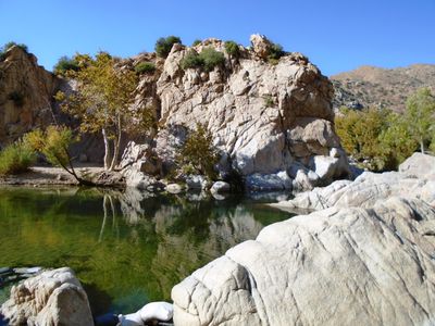
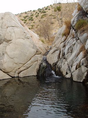
Deep Creek Hot Springs are natural thermal pools located in the San Bernardino National Forest foothills, where warm waters emerge along a mountain stream. Multiple bathing areas form at different temperatures, ranging from 38 to 40 degrees Celsius (100 to 105 degrees Fahrenheit), creating a series of accessible pools.

Indigenous peoples of the region relied on these thermal waters for generations, valuing them for their healing effects. As European settlement expanded into the San Bernardino Mountains, the site remained accessible and gradually became known to a wider population.

The springs draw visitors from around the world seeking a natural bathing experience, including many hikers traversing the Pacific Crest Trail through the region. Over time, the site has become a gathering place for people seeking freedom and a connection to the landscape.

Three different hiking routes reach the springs, including the Bowen Ranch Trail, Bradford Ridge Path, and Pacific Crest Trail, each demanding a good level of fitness. Visitors should prepare for desert conditions, carry ample water, and check trail conditions before heading out.

The pools support rare wildlife, including the endangered Southwestern Arroyo Toad, a small frog found nowhere else in such numbers. This amphibian depends on the specific stream conditions here, making the site crucial for its survival.

Location: San Bernardino County

GPS coordinates: 34.33940,-117.17700

Latest update: December 7, 2025 20:25

Photos
Around this place
Big Bear Lake
United States of America

Big Bear Lake

21.4 km
San Bernardino National Forest
United States of America

San Bernardino National Forest

114.4 km
Glen Helen Amphitheater
United States of America

Glen Helen Amphitheater

25.6 km
Lake Arrowhead Reservoir
United States of America

Lake Arrowhead Reservoir

9 km
Big Bear Solar Observatory
United States of America

Big Bear Solar Observatory

25.2 km
Lake Arrowhead Village Beach
United States of America

Lake Arrowhead Village Beach

9.6 km
Glen Helen Regional Park
United States of America

Glen Helen Regional Park

25.9 km
Alpine Slide
United States of America

Alpine Slide

26.2 km
Big Bear Discovery Center
United States of America

Big Bear Discovery Center

26.5 km
California Route 66 Museum
United States of America

California Route 66 Museum

24.5 km
Devil Canyon
United States of America

Devil Canyon

21.7 km
San Bernardino County Court House
United States of America

San Bernardino County Court House

28.1 km
Big Bear Snow Play
United States of America

Big Bear Snow Play

29.8 km
Goode Solar Telescope
United States of America

Goode Solar Telescope

25.2 km
Cajon Pass
United States of America

Cajon Pass

23.2 km
Santa Fe And Salt Lake Trail Monument
United States of America

Santa Fe And Salt Lake Trail Monument

26.9 km
Monument Peak
United States of America

Monument Peak

19.3 km
Santos Manuel Student Union
United States of America

Santos Manuel Student Union

22.2 km
Norman F. Feldheym Library
United States of America

Norman F. Feldheym Library

27.8 km
San Bernardino Valley Water Conservation Demonstration Garden
United States of America

San Bernardino Valley Water Conservation Demonstration Garden

22 km
Highland Historic District
United States of America

Highland Historic District

23.7 km
Arboreto Heaps Peak
United States of America

Arboreto Heaps Peak

12.1 km
San Bernardino History and Railroad Museum
United States of America

San Bernardino History and Railroad Museum

28.9 km
Rathaus von San Bernardino
United States of America

Rathaus von San Bernardino

28.2 km
Mountain History Museum
United States of America

Mountain History Museum

9.2 km
Keller Peak Lookout
United States of America

Keller Peak Lookout

19.8 km
Tavern Bay Beach
United States of America

Tavern Bay Beach

8.5 km
Hamiltair community Beach
United States of America

Hamiltair community Beach

9 km
Show the full map
Reviews

Visited this place? Tap the stars to rate it and share your experience / photos with the community! Try now! You can cancel it anytime.

« Deep Creek Hot Springs - Natural hot springs in San Bernardino National Forest, California » is provided by Around Us (aroundus.com). Images and texts are derived from Wikimedia project under a Creative Commons license. You are allowed to copy, distribute, and modify copies of this page, under the conditions set by the license, as long as this note is clearly visible.

Discover hidden gems everywhere you go!

From secret cafés to breathtaking viewpoints, skip the crowded tourist spots and find places that match your style. Our app makes it easy with voice search, smart filtering, route optimization, and insider tips from travelers worldwide. Download now for the complete mobile experience.

Around Us App Screenshot

A unique approach to discovering new places

Le Figaro

All the places worth exploring

France Info

A tailor-made excursion in just a few clicks

20 Minutes