Enable Location

We need your location to show you interesting places around you

Discover nearby places

Find interesting locations and hidden gems around you

Precise directions

Get accurate directions and distances to places

Your location is never shared with other users. It's only used when you tap the location button.

Starvation Creek Falls

Log in to your account

Start exploring — it's free

Trusted by 62,883 travelers worldwide

Continue with Google
Continue with Apple
or

We will send you a code to connect

By continuing, you accept our Terms and Conditions and our Privacy Policy

Check your inbox

We've sent a pincode in your inbox. Please enter the code below.

Starvation Creek Falls
Discussion Reviews 1 Photos
1.2k Popularity

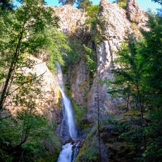
Starvation Creek Falls, Waterfall in Columbia River Gorge, United States

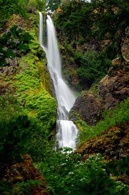
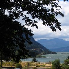
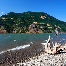
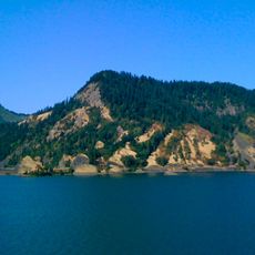
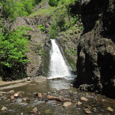
Starvation Creek Falls is a two-tiered waterfall in the Columbia River Gorge that descends about 190 feet (58 meters) through dense forest. The cascade creates a striking visual feature within the larger gorge setting and is surrounded by thick woodland vegetation.

The falls received their name in 1884 after a Pacific Express train with hundreds of passengers became stranded in heavy snow near this location during winter. That incident left a lasting mark on the region's identity and naming history.

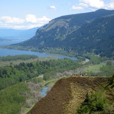
The falls serve as a testament to Oregon's preservation efforts, maintaining natural water features along the Historic Columbia River Highway State Trail system.

Access is available through a designated parking area at Exit 55 on Interstate 84, with a pathway leading directly to viewing areas. The short walk is relatively straightforward and suitable for most visitors with basic fitness levels.

The water source originates from underground springs beneath Viento Ridge and maintains steady flow year-round. This consistent supply allows the cascade to retain its full force even during drier months.

The community of curious travelers

AroundUs brings together thousands of curated places, local tips, and hidden gems, enriched daily by 60,000 contributors worldwide.

Start exploring
Location
GPS coordinates
45.68699,-121.68836
Latest update
December 14, 2025 18:05
Around this place
Columbia River Gorge
United States of America

Columbia River Gorge

8.3 km
Columbia River Gorge National Scenic Area
United States of America

Columbia River Gorge National Scenic Area

5.2 km
Mount Hood Railroad
United States of America

Mount Hood Railroad

14.4 km
Columbia Gorge Hotel
United States of America

Columbia Gorge Hotel

10.9 km
Starvation Creek State Park
United States of America

Starvation Creek State Park

144 m
Western Antique Aeroplane & Automobile Museum
United States of America

Western Antique Aeroplane & Automobile Museum

11.5 km
Viento State Park
United States of America

Viento State Park

1.8 km
Spring Creek Hatchery State Park
United States of America

Spring Creek Hatchery State Park

12.2 km
Lake Bonneville
United States of America

Lake Bonneville

9.8 km
Seneca Fouts Memorial State Natural Area
United States of America

Seneca Fouts Memorial State Natural Area

5.7 km
Hole-in-the-Wall Falls
United States of America

Hole-in-the-Wall Falls

1.1 km
Butler Bank
United States of America

Butler Bank

13.9 km
Cascade Locks Work Center
United States of America

Cascade Locks Work Center

12.1 km
Edward J. DeHart House
United States of America

Edward J. DeHart House

11.5 km
Simpson Copple House
United States of America

Simpson Copple House

13.3 km
Cliff Lodge
United States of America

Cliff Lodge

11.6 km
Martin and Carrie Hill House
United States of America

Martin and Carrie Hill House

14.1 km
Orrin B. Hartley House
United States of America

Orrin B. Hartley House

13.2 km
Davidson–Childs House
United States of America

Davidson–Childs House

13.5 km
Ernest S. and Clara C. Colby House
United States of America

Ernest S. and Clara C. Colby House

13.1 km
Roe–Parker House
United States of America

Roe–Parker House

13.8 km
Shaw–Dumble House
United States of America

Shaw–Dumble House

13.4 km
Robert and Mabel Loomis House
United States of America

Robert and Mabel Loomis House

13.2 km
Lester and Hazel Murphy House
United States of America

Lester and Hazel Murphy House

13.2 km
John C. Duckwall House
United States of America

John C. Duckwall House

13.5 km
Marina Beach
United States of America

Marina Beach

14.5 km
Home Valley Beach
United States of America

Home Valley Beach

7.4 km
Dog Creek Falls
United States of America

Dog Creek Falls

3 km
Show the full map
« Starvation Creek Falls - Waterfall in Columbia River Gorge, United States » is provided by Around Us (aroundus.com). Images and texts are derived from Wikimedia project under a Creative Commons license. You are allowed to copy, distribute, and modify copies of this page, under the conditions set by the license, as long as this note is clearly visible.

Discover hidden gems everywhere you go!

From secret cafés to breathtaking viewpoints, skip the crowded tourist spots and find places that match your style. Our app makes it easy with voice search, smart filtering, route optimization, and insider tips from travelers worldwide. Download now for the complete mobile experience.

Around Us App Screenshot

A unique approach to discovering new places

Le Figaro

All the places worth exploring

France Info

A tailor-made excursion in just a few clicks

20 Minutes

Around Us
Travel Guide & Maps
Download

Send to your phone

QR Code
1

Open the camera app on your mobile.

2

Point at the QR code with your camera. A notification will appear.

3

Tap the notification to open the link.