Chest opened
+${chestReward.xp} XP
Explorer
NOUVEAU ×${chestReward.collectible.quantity}
tapez pour fermer
Chest locked

Open chests in the app

Around Us is built for your phone — chests unlock when you walk, explore and capture nearby places.

Enable Location

We need your location to show you interesting places around you

Discover nearby places

Find interesting locations and hidden gems around you

Precise directions

Get accurate directions and distances to places

Your location is never shared with other users. It's only used when you tap the location button.

Log in to your account

Start exploring — it's free

Trusted by 73,077 travelers worldwide

Continue with Google
Continue with Apple
or

We will send you a code to connect

By continuing, you accept our Terms and Conditions and our Privacy Policy

Check your inbox

We've sent a pincode in your inbox. Please enter the code below.

Sea Bright-Monmouth Beach Seawall
Discussion Reviews Photo
3.1k Popularity

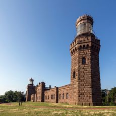
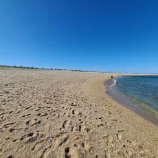
Sea Bright-Monmouth Beach Seawall, Coastal protection structure in Sea Bright, United States

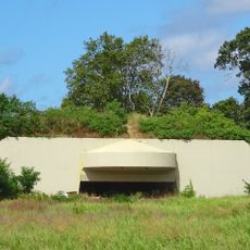
The Sea Bright-Monmouth Beach Seawall is a concrete barrier that runs for several kilometers along the Jersey Shore between the Atlantic Ocean and the Shrewsbury River estuary. The structure features designated access points where visitors can reach the beach and separates the waterfront from the residential areas beyond.

The seawall was first built in the late 1800s to protect the coastline from storms and erosion. It was expanded and reinforced multiple times over the following decades as coastal threats increased.

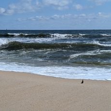
The seawall serves as a gathering spot where residents and visitors walk and enjoy waterfront activities together. It connects people with the shore and shapes how the community experiences the coastal landscape.

The seawall is accessible most of the year, though storms and rough conditions can occasionally limit access in certain areas. Visitors should wear appropriate footwear as surfaces can be slippery after rain or during wet weather.

After Hurricane Sandy, the seawall was reinforced with new sections and beaches were rebuilt with massive sand restoration efforts. This ongoing work shows how coastal protection constantly evolves to meet new challenges.

The community of curious travelers

AroundUs brings together thousands of curated places, local tips, and hidden gems, enriched daily by 60,000 contributors worldwide.

Start exploring
GPS coordinates
40.35893,-73.97434
Latest update
December 12, 2025 09:08
Around this place
Navesink Twin Lights
United States of America

Navesink Twin Lights

4.3 km
Two River Theater
United States of America

Two River Theater

8.6 km
Highlands Air Force Station
United States of America

Highlands Air Force Station

4 km
Hartshorne Woods Park
United States of America

Hartshorne Woods Park

3.6 km
Long Branch Pier
United States of America

Long Branch Pier

6.3 km
Parker Homestead
United States of America

Parker Homestead

7.2 km
Murry Guggenheim House
United States of America

Murry Guggenheim House

8.9 km
Seabright Lawn Tennis and Cricket Club
United States of America

Seabright Lawn Tennis and Cricket Club

1.2 km
Water Witch Club Casino
United States of America

Water Witch Club Casino

4.9 km
T. Thomas Fortune House
United States of America

T. Thomas Fortune House

8.7 km
Allen House
United States of America

Allen House

8.4 km
Fisk Chapel
United States of America

Fisk Chapel

5.7 km
St. George's-by-the-River Episcopal Church
United States of America

St. George's-by-the-River Episcopal Church

606 m
Christ Church , Shrewsbury
United States of America

Christ Church , Shrewsbury

8.3 km
Water Witch Club Historic District
United States of America

Water Witch Club Historic District

5 km
Lauren K. Woods Theatre
United States of America

Lauren K. Woods Theatre

9 km
Fort Hancock, U.S. Life Saving Station
United States of America

Fort Hancock, U.S. Life Saving Station

7.6 km
Battery Kingman
United States of America

Battery Kingman

8.9 km
Wardell House
United States of America

Wardell House

8.5 km
First Presbyterian Church of Rumson
United States of America

First Presbyterian Church of Rumson

3.6 km
Highlands–Sea Bright Bridge
United States of America

Highlands–Sea Bright Bridge

4.2 km
North Long Branch School-Primary No. 3
United States of America

North Long Branch School-Primary No. 3

4.3 km
Beach C
United States of America

Beach C

6.4 km
Beach E
United States of America

Beach E

7.8 km
Count Basie Theatre
United States of America

Count Basie Theatre

8.2 km
Navesink south lighthouse
United States of America

Navesink south lighthouse

4.3 km
Navesink north lighthouse
United States of America

Navesink north lighthouse

4.3 km
Victory Park
United States of America

Victory Park

3.8 km
Show the full map
Reviews
Share your experience

No review yet

Discussions
Start a discussion...

No discussion yet

« Sea Bright-Monmouth Beach Seawall - Coastal protection structure in Sea Bright, United States » is provided by Around Us (aroundus.com). Images and texts are derived from Wikimedia project under a Creative Commons license. You are allowed to copy, distribute, and modify copies of this page, under the conditions set by the license, as long as this note is clearly visible.

Discover hidden gems everywhere you go!

From secret cafés to breathtaking viewpoints, skip the crowded tourist spots and find places that match your style. Our app makes it easy with voice search, smart filtering, route optimization, and insider tips from travelers worldwide. Download now for the complete mobile experience.

Around Us App Screenshot

A unique approach to discovering new places

Le Figaro

All the places worth exploring

France Info

A tailor-made excursion in just a few clicks

20 Minutes

Around Us
Travel Guide & Maps
Download

Send to your phone

QR Code
1

Open the camera app on your mobile.

2

Point at the QR code with your camera. A notification will appear.

3

Tap the notification to open the link.