Chest opened
+${chestReward.xp} XP
Explorer
NOUVEAU ×${chestReward.collectible.quantity}
tapez pour fermer
Chest locked

Open chests in the app

Around Us is built for your phone — chests unlock when you walk, explore and capture nearby places.

Enable Location

We need your location to show you interesting places around you

Discover nearby places

Find interesting locations and hidden gems around you

Precise directions

Get accurate directions and distances to places

Your location is never shared with other users. It's only used when you tap the location button.

Log in to your account

Start exploring — it's free

Trusted by 72,885 travelers worldwide

Continue with Google
Continue with Apple
or

We will send you a code to connect

By continuing, you accept our Terms and Conditions and our Privacy Policy

Check your inbox

We've sent a pincode in your inbox. Please enter the code below.

Loud Dam
Discussion Reviews Photo
1.8k Popularity

Loud Dam, Hydroelectric dam in Iosco County, Michigan, US.

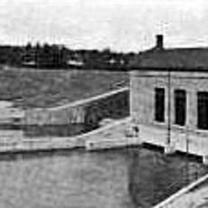
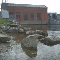
Loud Dam is a concrete structure with earthen embankments that spans the Au Sable River, creating a reservoir of about 937 acres. The facility was built to generate electricity and continues to serve that purpose today.

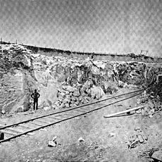
The dam was completed in 1913 by Consumers Power Company and named after Edward F. Loud, a prominent figure in Michigan's lumber industry. It was part of the early development of hydropower in the region.

This dam serves as a critical checkpoint during the annual Au Sable River Canoe Marathon, where paddlers navigate through a series of water management structures. The event has made this location well-known among the paddling community.

Two portage routes allow water enthusiasts to bypass the dam: a gravel path of about 250 yards with a canoe slide and a shorter but steeper alternative. Visitors should choose based on their skill level and available time.

The facility uses two horizontal Allis-Chalmers turbines to generate power, which surprises many visitors who expect modern equipment. This older technology still operates efficiently and reflects the heritage of early hydropower development.

The community of curious travelers

AroundUs brings together thousands of curated places, local tips, and hidden gems, enriched daily by 60,000 contributors worldwide.

Start exploring
Location
GPS coordinates
44.46444,-83.72111
Latest update
February 21, 2026 14:32
Around this place
Lumberman's Monument
United States of America

Lumberman's Monument

8.3 km
Sturgeon Point Light
United States of America

Sturgeon Point Light

44.9 km
Tawas Point State Park
United States of America

Tawas Point State Park

31.9 km
Harrisville State Park
United States of America

Harrisville State Park

39.5 km
Au Sable State Forest
United States of America

Au Sable State Forest

54.1 km
Tawas Point Light
United States of America

Tawas Point Light

31.9 km
Negwegon State Park
United States of America

Negwegon State Park

53.6 km
Charity Island Light
United States of America

Charity Island Light

52.5 km
Gravelly Shoal Light
United States of America

Gravelly Shoal Light

51.8 km
Tawas Point Camper's Beach
United States of America

Tawas Point Camper's Beach

31.7 km
Alabaster Historic District
United States of America

Alabaster Historic District

33.2 km
Five Channels Dam
United States of America

Five Channels Dam

3.7 km
Cooke Dam
United States of America

Cooke Dam

11.9 km
United States of America

Temple Beth El

69.9 km
Roscommon Zoo
United States of America

Roscommon Zoo

60.9 km
Harrisville State Park Beach
United States of America

Harrisville State Park Beach

39.6 km
Eggleston School
United States of America

Eggleston School

67.3 km
Oscoda County Courthouse
United States of America

Oscoda County Courthouse

38.4 km
Ogemaw Hills Pathway
United States of America

Ogemaw Hills Pathway

42.1 km
Bingham School
United States of America

Bingham School

70.1 km
Second Arenac County Courthouse
United States of America

Second Arenac County Courthouse

47.6 km
Dinosaur Gardens
United States of America

Dinosaur Gardens

54.8 km
Caseville Harbor Light
United States of America

Caseville Harbor Light

67.6 km
White Pine National
United States of America

White Pine National

36 km
Wurtsmith Air Museum
United States of America

Wurtsmith Air Museum

28.9 km
Wild Frontier Fun Park
United States of America

Wild Frontier Fun Park

43.9 km
CoopersVille USA
United States of America

CoopersVille USA

58.6 km
Au Sable National Scenic River
United States of America

Au Sable National Scenic River

28.2 km
Show the full map
Reviews
Share your experience

No review yet

Discussions
Start a discussion...

No discussion yet

« Loud Dam - Hydroelectric dam in Iosco County, Michigan, US » is provided by Around Us (aroundus.com). Images and texts are derived from Wikimedia project under a Creative Commons license. You are allowed to copy, distribute, and modify copies of this page, under the conditions set by the license, as long as this note is clearly visible.

Discover hidden gems everywhere you go!

From secret cafés to breathtaking viewpoints, skip the crowded tourist spots and find places that match your style. Our app makes it easy with voice search, smart filtering, route optimization, and insider tips from travelers worldwide. Download now for the complete mobile experience.

Around Us App Screenshot

A unique approach to discovering new places

Le Figaro

All the places worth exploring

France Info

A tailor-made excursion in just a few clicks

20 Minutes

Around Us
Travel Guide & Maps
Download

Send to your phone

QR Code
1

Open the camera app on your mobile.

2

Point at the QR code with your camera. A notification will appear.

3

Tap the notification to open the link.