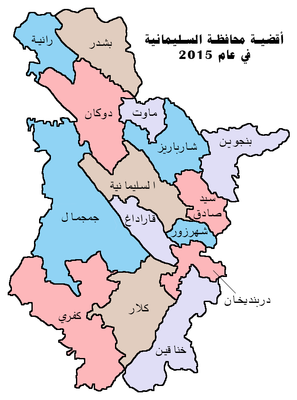
Penjwin District, district in Kurdistan, Iraq
Location: Sulaymaniyah Governorate
GPS coordinates: 35.62366,45.94954
Latest update: April 13, 2025 17:56
Amna Suraka
47.9 km
Sulaymaniyah Museum
48 km
Darbandikhan Dam
61 km
Rabana-Merquly
65.8 km
Cultural Landscape of Hawraman/Uramanat
74.9 km
Hazar Merd Cave
62.9 km
Rabat Tepe
74.2 km
Do Menareh Mosque
74.1 km
Shalmash Falls
66.9 km
Bakr Awa
44.9 km
Saqqez Bazaar
74.3 km
Tell Kunara
54.7 km
Bestansur
38.9 km
Haj Saleh Hammam
74.3 km
بازار مولوی
46.1 km
Kurd's Heritage Museum (Sulaymaniyah)
46.7 km
Halabja Stadium
46.8 km
Garran Bridge
33.7 km
Yasin Tepe
40 km
Rabana rock relief
67.8 km
The Stone cave Hossein Kuhkan
83.8 km
Darband-i Belula
77.9 km
Qimmat Merquli
66.5 km
Sheikh Mazhar Mosque
74 km
Rock relief of Naram-Suen, Sulaymaniyah
66.3 km
Marivan Castle
25.3 km
Omar ibn al-Khattab Mosque (Saqqez)
74.8 km
Tajavanchi Caravanserai
74.2 kmReviews
Visited this place? Tap the stars to rate it and share your experience / photos with the community! Try now! You can cancel it anytime.
Discover hidden gems everywhere you go!
From secret cafés to breathtaking viewpoints, skip the crowded tourist spots and find places that match your style. Our app makes it easy with voice search, smart filtering, route optimization, and insider tips from travelers worldwide. Download now for the complete mobile experience.
A unique approach to discovering new places❞
— Le Figaro
All the places worth exploring❞
— France Info
A tailor-made excursion in just a few clicks❞
— 20 Minutes