Enable Location

We need your location to show you interesting places around you

Discover nearby places

Find interesting locations and hidden gems around you

Precise directions

Get accurate directions and distances to places

Your location is never shared with other users. It's only used when you tap the location button.

Pedro Leopoldo

Log in to your account

Start exploring — it's free

Trusted by 62,589 travelers worldwide

Continue with Google
Continue with Apple
or

We will send you a code to connect

By continuing, you accept our Terms and Conditions and our Privacy Policy

Check your inbox

We've sent a pincode in your inbox. Please enter the code below.

Pedro Leopoldo, Administrative municipality in Minas Gerais, Brazil.

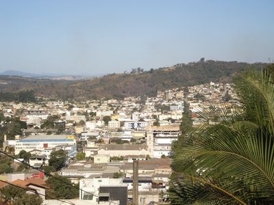
Pedro Leopoldo is a municipality in the Greater Belo Horizonte region, situated at about 846 meters in elevation. The town spreads across residential and commercial neighborhoods, with natural areas and archaeological sites scattered throughout the landscape.

The town received its official status in 1924 following the establishment of textile factories and the building of a major railway station. This infrastructure shaped its growth and connected it to the broader regional network.

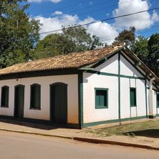
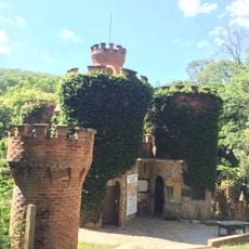
The Casa Fernão Dias museum displays objects and documents from the era of bandeirante expeditions across the region. Visitors can trace the history of these exploratory journeys and learn how early explorers moved through the Brazilian interior.

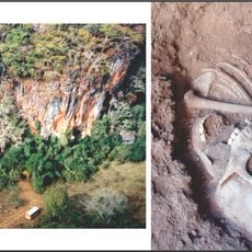
The area contains roughly half of Sumidouro State Park, where visitors can explore the landscape on trails. Plan for uneven terrain and allow sufficient time to walk through these natural areas.

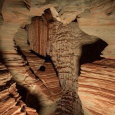
Danish naturalist Peter Lund studied the local caves in the 1830s and uncovered significant prehistoric human remains. His work made the region an early center of archaeological research in South America.

The community of curious travelers

AroundUs brings together thousands of curated places, local tips, and hidden gems, enriched daily by 60,000 contributors worldwide.

Start exploring
Location
Inception
1924
Elevation above the sea
846 m
Shares border with
Confins, Matozinhos, Esmeraldas, Jaboticatubas, Lagoa Santa, Ribeirão das Neves, São José da Lapa, Vespasiano
GPS coordinates
-19.61778,-44.04278
Latest update
December 20, 2025 02:28
« Pedro Leopoldo - Administrative municipality in Minas Gerais, Brazil » is provided by Around Us (aroundus.com). Images and texts are derived from Wikimedia project under a Creative Commons license. You are allowed to copy, distribute, and modify copies of this page, under the conditions set by the license, as long as this note is clearly visible.

Discover hidden gems everywhere you go!

From secret cafés to breathtaking viewpoints, skip the crowded tourist spots and find places that match your style. Our app makes it easy with voice search, smart filtering, route optimization, and insider tips from travelers worldwide. Download now for the complete mobile experience.

Around Us App Screenshot

A unique approach to discovering new places

Le Figaro

All the places worth exploring

France Info

A tailor-made excursion in just a few clicks

20 Minutes

Around Us
Travel Guide & Maps
Download

Send to your phone

QR Code
1

Open the camera app on your mobile.

2

Point at the QR code with your camera. A notification will appear.

3

Tap the notification to open the link.