Tojo Una Una Regency, Administrative region in Central Sulawesi, Indonesia
Tojo Una Una is an administrative region in Central Sulawesi that spans the eastern peninsula and includes the Togian Islands in the Gulf of Tomini. The area is divided into twelve districts distributed across the mainland and the island archipelago offshore.
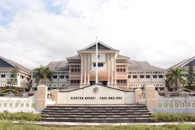
The region was established on December 18, 2003, carved out from the northeastern districts of Poso Regency, with Ampana Kota set as its administrative center. This creation brought a new territorial unit into existence with its own governance structure.
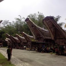
The population lives across two distinct environments: the mainland and the islands, where fishing and farming remain central to daily life. This split geography has shaped different ways of living depending on where people settle.
Visitors typically arrive through Ampana Kota on the mainland and can then travel by boat to the Togian Islands, which takes several hours offshore. The best time to explore is during the drier months when the sea is calmer.
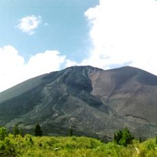
The Una Una volcanic island experienced a major eruption in 1983 and now hosts three small villages nestled among coconut plantations. This resettled life on an active volcano shows the resilience of the local people.
Location: Central Sulawesi
Capital city: Ampana Kota
Elevation above the sea: 1,276 m
Shares border with: Banggai Regency, North Morowali Regency, Poso Regency
GPS coordinates: -0.87556,121.63000
Latest update: December 7, 2025 19:30
Lore Lindu National Park
176 kmJesus Buntu Burake
315 km
Kete Kesu
304.2 km
Buntu Rantemario
331.6 km
Gunung Soputanpatepangan
410 km
Kepulauan Togean National Park
70.5 kmAl-Alam Kendari Mosque
360 km
Otanaha Fortress
220.6 km
Palopo Old Mosque
284.8 km
Palu IV Bridge
197.1 km
Bogani Nani Wartabone National Park
278.6 km
Floating Mosque of Palu
197.7 km
Colo
78.6 km
Rawa Aopa Watumohai National Park
392.5 km
Mount Tondano
426.4 km
Mount Empung
430.9 km
Pokekea Megalithic Site
182 km
Pantai Indah Modisi
344.9 km
Rumah Katu Marine Park
131.6 km
Sintuwu Maroso Square
113.2 km
Museum dan Monumen Pendaratan Pesawat Ampibi Catalina
220.4 km
Gereja GMIBM Efrata Modisi
345.5 km
Bulud Kanari
346.1 km
Taman Nasional Hutan Mangrove
345.3 km
Modisi Beach
343.6 km
Gereja GPDI Modisi
345.7 km
Benteng weir
381.1 km
Gereja KGPM Modisi
345.4 kmVisited this place? Tap the stars to rate it and share your experience / photos with the community! Try now! You can cancel it anytime.
Discover hidden gems everywhere you go!
From secret cafés to breathtaking viewpoints, skip the crowded tourist spots and find places that match your style. Our app makes it easy with voice search, smart filtering, route optimization, and insider tips from travelers worldwide. Download now for the complete mobile experience.
A unique approach to discovering new places❞
— Le Figaro
All the places worth exploring❞
— France Info
A tailor-made excursion in just a few clicks❞
— 20 Minutes