Chest opened
+${chestReward.xp} XP
Explorer
NOUVEAU ×${chestReward.collectible.quantity}
tapez pour fermer

See the monuments around you in AR Open chests in the app

Around Us is built for your phone — point your camera at the streets and discover the monuments and places around you in augmented reality. Around Us is built for your phone — chests unlock when you walk, explore and capture nearby places.

•

Enable Location

We need your location to show you interesting places around you

Discover nearby places

Find interesting locations and hidden gems around you

Precise directions

Get accurate directions and distances to places

Your location is never shared with other users. It's only used when you tap the location button.

Fort Denison Light

Log in to your account

Start exploring — it's free

Trusted by 94,260 travelers worldwide

Continue with Google
Continue with Apple
or

We will send you a code to connect

By continuing, you accept our Terms and Conditions and our Privacy Policy

Check your inbox

We've sent a pincode in your inbox. Please enter the code below.

Fort Denison Light

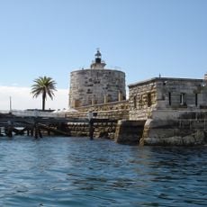
Fort Denison Light, Maritime lighthouse at Fort Denison in Sydney Harbour, Australia

Fort Denison Light is a lighthouse mounted atop a Martello tower on a small island in Sydney Harbour, with its lantern structure manufactured in Birmingham and installed in 1913. The tower stands as a navigational landmark and guide for vessels entering the harbor.

The lighthouse was first illuminated in 1913 with an acetylene gas carbide lamp, which operated until 1926 when electrical power took over the function. This shift reflects the gradual modernization of maritime safety technology in Sydney Harbour.

The island's nickname, Pinchgut, comes from the convicts of the penal settlement who were put on short rations there; the light is still called Pinchgut Light. The station keeps a fog bell and navigation channel markers alongside the tower, and the island has been part of Sydney Harbour National Park since 1992.

The island is reached by boat, and visits are by guided tour only, with a fee and a reservation required. The tower itself is open to the public on these tours. The site has been managed by the NSW National Parks & Wildlife Service since 1992 as part of Sydney Harbour National Park.

A tide gauge station at the island has been recording water levels in the harbor since the mid-1800s and contributes to important scientific data. This continuous measurement makes the location a valuable observation point for maritime research.

The community of curious travelers

AroundUs brings together thousands of curated places, local tips, and hidden gems, enriched daily by 94,260 contributors worldwide.

Start exploring
Location
Part of
Fort Denison
GPS coordinates
-33.85460,151.22600
Latest update
November 1, 2026 00:55
Reviews
Share your experience

No review yet

Discussions
Start a discussion...

No discussion yet

« Fort Denison Light - Maritime lighthouse at Fort Denison in Sydney Harbour, Australia » is provided by Around Us (aroundus.com). Images and texts are derived from Wikimedia project under a Creative Commons license. You are allowed to copy, distribute, and modify copies of this page, under the conditions set by the license, as long as this note is clearly visible.

Discover hidden gems everywhere you go!

From secret cafés to breathtaking viewpoints, skip the crowded tourist spots and find places that match your style. Our app makes it easy with voice search, smart filtering, route optimization, and insider tips from travelers worldwide. Download now for the complete mobile experience.

Around Us App Screenshot
❝

A unique approach to discovering new places❞

— Le Figaro

❝

All the places worth exploring❞

— France Info

❝

A tailor-made excursion in just a few clicks❞

— 20 Minutes

Around Us
Travel Guide & Maps
Download

Send to your phone

QR Code
1

Open the camera app on your mobile.

2

Point at the QR code with your camera. A notification will appear.

3

Tap the notification to open the link.