Enable Location

We need your location to show you interesting places around you

Discover nearby places

Find interesting locations and hidden gems around you

Precise directions

Get accurate directions and distances to places

Your location is never shared with other users. It's only used when you tap the location button.

Barbers Point Light

Log in to your account

Start exploring — it's free

Trusted by 62,023 travelers worldwide

Continue with Google
Continue with Apple
or

We will send you a code to connect

By continuing, you accept our Terms and Conditions and our Privacy Policy

Check your inbox

We've sent a pincode in your inbox. Please enter the code below.

Barbers Point Light

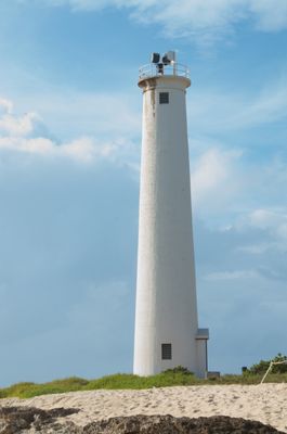
Barbers Point Light, Coastal lighthouse in Honolulu County, US.

Barbers Point Light is a white cylindrical concrete tower standing on the coast of Honolulu County. The tower rises about 71 feet, while its beacon is positioned approximately 85 feet above sea level and shines out across the water at night.

The original structure at this location was built in 1888 from coral stone to guide ships along the Hawaiian coast. In 1933 it was replaced by the current concrete tower, which continues to stand today.

This lighthouse has long served as a visual landmark that boat operators and fishermen use to navigate and identify the coastline. The local community views it as a symbol of maritime safety and protection for those who work and travel on the water.

Access to the lighthouse comes through Barbers Point Beach Park, which offers parking and walking paths along the coast. Visitors should note that coastal conditions vary by season and some paths may be unpaved.

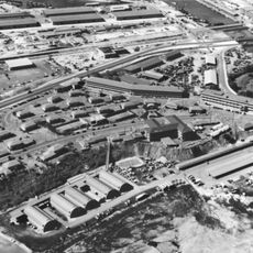
A lighthouse keeper recorded direct observations of the Pearl Harbor attack from this location. These observations made the tower a historically significant point during one of the most pivotal events in American history.

The community of curious travelers

AroundUs brings together thousands of curated places, local tips, and hidden gems, enriched daily by 60,000 contributors worldwide.

Start exploring
Location
GPS coordinates
21.29636,-158.10617
Latest update
December 13, 2025 12:41
Around this place
USS Missouri
United States of America

USS Missouri

17.5 km
Aloha Stadium
United States of America

Aloha Stadium

20.2 km
Naval Station Pearl Harbor
United States of America

Naval Station Pearl Harbor

17.8 km
Hickam Field
United States of America

Hickam Field

19.2 km
Wheeler Army Airfield
United States of America

Wheeler Army Airfield

21.6 km
Bishop Museum
United States of America

Bishop Museum

24.8 km
USS Bowfin
United States of America

USS Bowfin

19.1 km
Kaʻala
United States of America

Kaʻala

23.8 km
Admiral Clarey Bridge
United States of America

Admiral Clarey Bridge

18.7 km
Pacific Aviation Museum Pearl Harbor
United States of America

Pacific Aviation Museum Pearl Harbor

16.5 km
Fort Kamehameha
United States of America

Fort Kamehameha

15.5 km
Kukaniloko Birth Site
United States of America

Kukaniloko Birth Site

24.5 km
Wet'n'Wild Hawaii
United States of America

Wet'n'Wild Hawaii

4.7 km
Commander in Chief Pacific Fleet Headquarters
United States of America

Commander in Chief Pacific Fleet Headquarters

19.2 km
Hawaiian Railway Society
United States of America

Hawaiian Railway Society

7.4 km
Hawaii Kotohira Jinsha – Hawaii Dazaifu Tenmangu
United States of America

Hawaii Kotohira Jinsha – Hawaii Dazaifu Tenmangu

24.8 km
Jhamandas Watumull Planetarium
United States of America

Jhamandas Watumull Planetarium

24.8 km
Submarine Memorial Chapel
United States of America

Submarine Memorial Chapel

18.2 km
Wahiawa Botanical Garden
United States of America

Wahiawa Botanical Garden

24.8 km
Aloha Jewish Chapel
United States of America

Aloha Jewish Chapel

18.7 km
Keaīwa Heiau State Recreation Area
United States of America

Keaīwa Heiau State Recreation Area

24.4 km
United States Immigration Office
United States of America

United States Immigration Office

24.9 km
Waimalu Shopping Center
United States of America

Waimalu Shopping Center

19 km
Tropic Lightning Museum
United States of America

Tropic Lightning Museum

22.4 km
Waipahu Theater
United States of America

Waipahu Theater

14.4 km
Sharkey Theater
United States of America

Sharkey Theater

18.3 km
Honolulu Magnetic Observatory
United States of America

Honolulu Magnetic Observatory

11.3 km
The Arrival of Filipino Plantation Workers in Hawaii historical marker
United States of America

The Arrival of Filipino Plantation Workers in Hawaii historical marker

14.5 km
Show the full map
« Barbers Point Light - Coastal lighthouse in Honolulu County, US » is provided by Around Us (aroundus.com). Images and texts are derived from Wikimedia project under a Creative Commons license. You are allowed to copy, distribute, and modify copies of this page, under the conditions set by the license, as long as this note is clearly visible.

Discover hidden gems everywhere you go!

From secret cafés to breathtaking viewpoints, skip the crowded tourist spots and find places that match your style. Our app makes it easy with voice search, smart filtering, route optimization, and insider tips from travelers worldwide. Download now for the complete mobile experience.

Around Us App Screenshot

A unique approach to discovering new places

Le Figaro

All the places worth exploring

France Info

A tailor-made excursion in just a few clicks

20 Minutes

Around Us
Travel Guide & Maps
Download

Send to your phone

QR Code
1

Open the camera app on your mobile.

2

Point at the QR code with your camera. A notification will appear.

3

Tap the notification to open the link.