Enable Location

We need your location to show you interesting places around you

Discover nearby places

Find interesting locations and hidden gems around you

Precise directions

Get accurate directions and distances to places

Your location is never shared with other users. It's only used when you tap the location button.

South Yuyanq’ Ch’ex

Log in to your account

Start exploring — it's free

Trusted by travelers worldwide

Continue with Google
Continue with Apple
or

We will send you a code to connect

By continuing, you accept our Terms and Conditions and our Privacy Policy

Check your inbox

We've sent a pincode in your inbox. Please enter the code below.

South Yuyanq’ Ch’ex

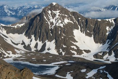
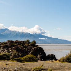
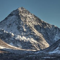
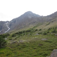
South Yuyanq’ Ch’ex, Mountain summit in Chugach State Park, Alaska, United States.

Description

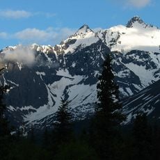
This mountain rises about 5,000 feet above sea level and displays a distinctive pyramidal shape that stands out against the surrounding Chugach range. Its location near Turnagain Arm makes it a notable point in the landscape, positioned between the mountains, water, and the Anchorage area.

History

The peak was previously called South Suicide Peak before receiving its current name from the Dena'ina language, meaning Heaven's Breath. This name change reflects growing recognition of the region's indigenous cultural heritage.

Culture

The peak carries a name rooted in the Dena'ina language, reflecting the indigenous connection to this mountain landscape. Local climbers view this place as part of their mountaineering tradition and regularly share their experiences on various climbing platforms.

Practical

The Falls Creek route is the most commonly used path, starting at the Falls Creek Trailhead with the initial section covering several miles. The hike crosses varied terrain and can be demanding depending on conditions, so proper preparation and suitable gear make the experience more manageable.

Did you know?

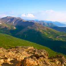
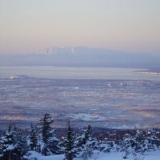
From the summit, visitors can see three very different landscapes side by side: the Chugach mountain ridges, the waters of Turnagain Arm, and Anchorage in the distance. This view bringing together wilderness and urban development in one sight is uncommon in the region.

Location
GPS coordinates
61.02941,-149.57530
Latest update
December 14, 2025 14:43

AroundUs brings together thousands of curated places, local tips, and hidden gems, enriched daily by 60,000 contributors worldwide. Discover all places nearby (Alaska).

Around this place
Alaska Zoo
United States of America

Alaska Zoo

15.8 km
Flattop Mountain
United States of America

Flattop Mountain

8.4 km
Anchorage Museum
United States of America

Anchorage Museum

26.6 km
Bartlett High School
United States of America

Bartlett High School

24.1 km
Alaska Native Heritage Center
United States of America

Alaska Native Heritage Center

23.9 km
Robert B. Atwood Building
United States of America

Robert B. Atwood Building

26.8 km
Our Lady of Guadalupe Co-Cathedral
United States of America

Our Lady of Guadalupe Co-Cathedral

26.3 km
Beluga Point Site
United States of America

Beluga Point Site

7 km
Anchorage Alaska Temple
United States of America

Anchorage Alaska Temple

16.4 km
Alaska Botanical Garden
United States of America

Alaska Botanical Garden

19.2 km
McKinley Tower Apartments
United States of America

McKinley Tower Apartments

26.6 km
UAA/APU Consortium Library
United States of America

UAA/APU Consortium Library

22.2 km
H2Oasis Indoor Waterpark
United States of America

H2Oasis Indoor Waterpark

18.2 km
Dena'ina Civic and Convention Center
United States of America

Dena'ina Civic and Convention Center

26.8 km
Pilgrim 100-B N709Y
United States of America

Pilgrim 100-B N709Y

26.9 km
Polar Bear Peak
United States of America

Polar Bear Peak

24.4 km
Chester Creek
United States of America

Chester Creek

25.3 km
United States of America

Eagle Peak

22.4 km
North Yuyanq’ Ch’ex
United States of America

North Yuyanq’ Ch’ex

1.2 km
Ptarmigan Peak
United States of America

Ptarmigan Peak

3.6 km
Pioneer School House
United States of America

Pioneer School House

26.6 km
Anchorage Coastal Wildlife Refuge
United States of America

Anchorage Coastal Wildlife Refuge

19.5 km
Wendler Building
United States of America

Wendler Building

26.9 km
Potter Section House
United States of America

Potter Section House

12.1 km
Atwood Campus Center
United States of America

Atwood Campus Center

21.6 km
Loussac-Sogn Building
United States of America

Loussac-Sogn Building

26.9 km
Metropolia Anchorage
United States of America

Metropolia Anchorage

26.8 km
St. Innocent Russian Orthodox Cathedral
United States of America

St. Innocent Russian Orthodox Cathedral

23.1 km
Show the full map
« South Yuyanq’ Ch’ex - Mountain summit in Chugach State Park, Alaska, United States » is provided by Around Us (aroundus.com). Images and texts are derived from Wikimedia project under a Creative Commons license. You are allowed to copy, distribute, and modify copies of this page, under the conditions set by the license, as long as this note is clearly visible.

Discover hidden gems everywhere you go!

From secret cafés to breathtaking viewpoints, skip the crowded tourist spots and find places that match your style. Our app makes it easy with voice search, smart filtering, route optimization, and insider tips from travelers worldwide. Download now for the complete mobile experience.

Around Us App Screenshot

A unique approach to discovering new places

Le Figaro

All the places worth exploring

France Info

A tailor-made excursion in just a few clicks

20 Minutes

Around Us
Travel Guide & Maps
Download

Send to your phone

QR Code
1

Open the camera app on your mobile.

2

Point at the QR code with your camera. A notification will appear.

3

Tap the notification to open the link.