Enable Location

We need your location to show you interesting places around you

Discover nearby places

Find interesting locations and hidden gems around you

Precise directions

Get accurate directions and distances to places

Your location is never shared with other users. It's only used when you tap the location button.

Arroyo Seco Parkway

Log in to your account

Start exploring — it's free

Trusted by 61,770 travelers worldwide

Continue with Google
Continue with Apple
or

We will send you a code to connect

By continuing, you accept our Terms and Conditions and our Privacy Policy

Check your inbox

We've sent a pincode in your inbox. Please enter the code below.

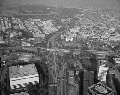
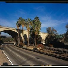
Arroyo Seco Parkway, Historic parkway between Los Angeles and Pasadena, United States.

Description

Arroyo Seco Parkway is a historic route connecting downtown Los Angeles to Pasadena, running through a narrow canyon. The road follows the Arroyo Seco streambed, passes through four decorated tunnels, and crosses several stone bridges that still display the original parkway design.

History

The route opened in 1940 as California's first limited-access highway, linking two growing cities with a new type of construction. It marked the shift from ordinary boulevards to modern expressways and later became part of the legendary Route 66.

Culture

This route shaped the way later California highways were designed, with its flowing curves and landscape-integrated sections. The stone and decorative treatment of bridges and passages still reflects the ambition to design traffic routes as crafted experiences.

Practical

The narrow lanes and lack of acceleration zones require extra caution and slower speeds when driving. Some entrances and exits follow older patterns, with sharp curves and short connecting ramps.

Did you know?

The four Figueroa Street tunnels display distinct Art Deco architectural elements and frequently appear in film productions. Their facades and entrances were deliberately designed to give drivers a visual experience beyond mere function.

Location
Location
Location
Inception
1940
GPS coordinates
34.10221,-118.19900
Latest update
December 17, 2025 08:34

AroundUs brings together thousands of curated places, local tips, and hidden gems, enriched daily by 60,000 contributors worldwide. Discover all places nearby (Los Angeles).

Around this place
Heritage Square Museum
United States of America

Heritage Square Museum

1.8 km
Lummis House
United States of America

Lummis House

1.2 km
Lincoln Heights Jail
United States of America

Lincoln Heights Jail

3.6 km
Lincoln Park
United States of America

Lincoln Park

4 km
Chicken Boy
United States of America

Chicken Boy

826 m
Hale House
United States of America

Hale House

1.8 km
Southwest Museum of the American Indian
United States of America

Southwest Museum of the American Indian

657 m
Rio de Los Angeles State Park
United States of America

Rio de Los Angeles State Park

3.4 km
Judson Studios
United States of America

Judson Studios

2.2 km
Pisgah Home Historic District
United States of America

Pisgah Home Historic District

1.5 km
Cawston Ostrich Farm
United States of America

Cawston Ostrich Farm

2.7 km
Ernest E. Debs Regional Park
United States of America

Ernest E. Debs Regional Park

831 m
Smith Estate
United States of America

Smith Estate

1.5 km
Constance Perkins House
United States of America

Constance Perkins House

3.7 km
Highland Park Masonic Temple
United States of America

Highland Park Masonic Temple

878 m
Santa Fe Arroyo Seco Railroad Bridge
United States of America

Santa Fe Arroyo Seco Railroad Bridge

1.7 km
Glassell Park Elementary School
United States of America

Glassell Park Elementary School

3.5 km
Ernest and Florence Bent Halstead House and Grounds
United States of America

Ernest and Florence Bent Halstead House and Grounds

1.4 km
Richard Henry Dana Branch
United States of America

Richard Henry Dana Branch

2.4 km
Ziegler Estate
United States of America

Ziegler Estate

642 m
Lincoln Heights Branch
United States of America

Lincoln Heights Branch

3.2 km
Mount Pleasant House
United States of America

Mount Pleasant House

1.7 km
John Norton House
United States of America

John Norton House

3.8 km
Wynyate
United States of America

Wynyate

3.9 km
Reservoir Dogs - Pat and Lorraine's Coffee Shop
United States of America

Reservoir Dogs - Pat and Lorraine's Coffee Shop

3.5 km
Selig Zoo
United States of America

Selig Zoo

3.9 km
Cypress Park Branch
United States of America

Cypress Park Branch

3 km
York Boulevard Bridge
United States of America

York Boulevard Bridge

2.3 km
Show the full map
« Arroyo Seco Parkway - Historic parkway between Los Angeles and Pasadena, United States » is provided by Around Us (aroundus.com). Images and texts are derived from Wikimedia project under a Creative Commons license. You are allowed to copy, distribute, and modify copies of this page, under the conditions set by the license, as long as this note is clearly visible.

Discover hidden gems everywhere you go!

From secret cafés to breathtaking viewpoints, skip the crowded tourist spots and find places that match your style. Our app makes it easy with voice search, smart filtering, route optimization, and insider tips from travelers worldwide. Download now for the complete mobile experience.

Around Us App Screenshot

A unique approach to discovering new places

Le Figaro

All the places worth exploring

France Info

A tailor-made excursion in just a few clicks

20 Minutes

Around Us
Travel Guide & Maps
Download

Send to your phone

QR Code
1

Open the camera app on your mobile.

2

Point at the QR code with your camera. A notification will appear.

3

Tap the notification to open the link.