Enable Location

We need your location to show you interesting places around you

Discover nearby places

Find interesting locations and hidden gems around you

Precise directions

Get accurate directions and distances to places

Your location is never shared with other users. It's only used when you tap the location button.

Ernest E. Debs Regional Park

Log in to your account

Start exploring — it's free

Trusted by 65,098 travelers worldwide

Continue with Google
Continue with Apple
or

We will send you a code to connect

By continuing, you accept our Terms and Conditions and our Privacy Policy

Check your inbox

We've sent a pincode in your inbox. Please enter the code below.

Ernest E. Debs Regional Park
Discussion Reviews 1 Photos
4.7k Popularity

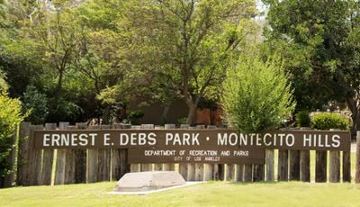
Ernest E. Debs Regional Park, Nature reserve in northeastern Los Angeles, California, US

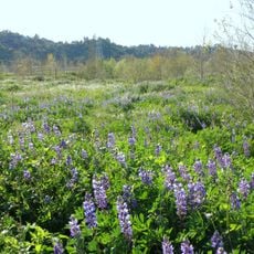
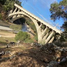
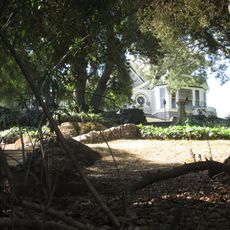
Ernest E. Debs Regional Park is a nature reserve in northeastern Los Angeles, California, with oak and walnut woodlands, open meadows, and a small pond. Trails wind through the tree cover and reach open spots with views over the city below.

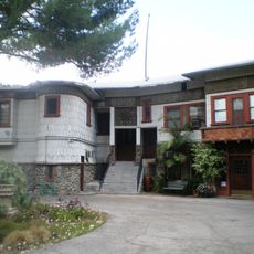
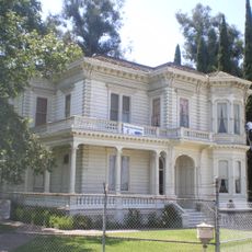
The land was set aside by Los Angeles in 1949 as Rose Hill Park and later renamed to honor Ernest E. Debs, a long-serving Los Angeles County Supervisor. Over time the park grew in size and the Audubon Center was added as a new facility on the grounds.

The Audubon Center inside the park runs nature education programs that are open to school groups and families. Visitors can sometimes watch volunteers working on native plant restoration along the trails.

The park can be entered from Griffin Avenue or Monterey Road, and both entry points have parking areas nearby. Trails vary in length and steepness, so it helps to choose your route before you start walking.

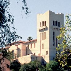
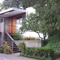
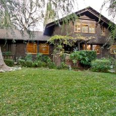
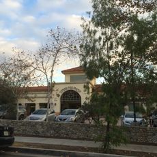
The Audubon Center on the grounds is one of the earliest certified carbon-neutral buildings in the US, completed at a time when green architecture was still rare. The building uses rainwater collection and solar power, features that are visible during a visit to the center.

The community of curious travelers

AroundUs brings together thousands of curated places, local tips, and hidden gems, enriched daily by 60,000 contributors worldwide.

Start exploring
Location
Operator
City of Los Angeles
GPS coordinates
34.09600,-118.19400
Latest update
March 3, 2026 10:07
Around this place
Los Angeles County+USC Medical Center
United States of America

Los Angeles County+USC Medical Center

4.3 km
Heritage Square Museum
United States of America

Heritage Square Museum

1.6 km
Lummis House
United States of America

Lummis House

1.2 km
Lincoln Park
United States of America

Lincoln Park

3.3 km
Chicken Boy
United States of America

Chicken Boy

1.4 km
Hale House
United States of America

Hale House

1.6 km
Southwest Museum of the American Indian
United States of America

Southwest Museum of the American Indian

1.2 km
Rio de Los Angeles State Park
United States of America

Rio de Los Angeles State Park

3.9 km
Judson Studios
United States of America

Judson Studios

2.4 km
Pisgah Home Historic District
United States of America

Pisgah Home Historic District

1.8 km
Cawston Ostrich Farm
United States of America

Cawston Ostrich Farm

2.7 km
Smith Estate
United States of America

Smith Estate

2.1 km
Woman's Building
United States of America

Woman's Building

4.2 km
Constance Perkins House
United States of America

Constance Perkins House

4.1 km
Highland Park Masonic Temple
United States of America

Highland Park Masonic Temple

1.5 km
Santa Fe Arroyo Seco Railroad Bridge
United States of America

Santa Fe Arroyo Seco Railroad Bridge

1.9 km
Glassell Park Elementary School
United States of America

Glassell Park Elementary School

4 km
Ernest and Florence Bent Halstead House and Grounds
United States of America

Ernest and Florence Bent Halstead House and Grounds

1.6 km
Richard Henry Dana Branch
United States of America

Richard Henry Dana Branch

2.6 km
Ziegler Estate
United States of America

Ziegler Estate

1 km
Lincoln Heights Branch
United States of America

Lincoln Heights Branch

2.9 km
San Rafael Bridge
United States of America

San Rafael Bridge

4.2 km
Mount Pleasant House
United States of America

Mount Pleasant House

1.5 km
John Norton House
United States of America

John Norton House

4.1 km
Wynyate
United States of America

Wynyate

3.7 km
Selig Zoo
United States of America

Selig Zoo

3.2 km
Cypress Park Branch
United States of America

Cypress Park Branch

3.3 km
York Boulevard Bridge
United States of America

York Boulevard Bridge

2.4 km
Show the full map
Reviews
Share your experience

No review yet

Discussions
Start a discussion...

No discussion yet

« Ernest E. Debs Regional Park - Nature reserve in northeastern Los Angeles, California, US » is provided by Around Us (aroundus.com). Images and texts are derived from Wikimedia project under a Creative Commons license. You are allowed to copy, distribute, and modify copies of this page, under the conditions set by the license, as long as this note is clearly visible.

Discover hidden gems everywhere you go!

From secret cafés to breathtaking viewpoints, skip the crowded tourist spots and find places that match your style. Our app makes it easy with voice search, smart filtering, route optimization, and insider tips from travelers worldwide. Download now for the complete mobile experience.

Around Us App Screenshot

A unique approach to discovering new places

Le Figaro

All the places worth exploring

France Info

A tailor-made excursion in just a few clicks

20 Minutes

Around Us
Travel Guide & Maps
Download

Send to your phone

QR Code
1

Open the camera app on your mobile.

2

Point at the QR code with your camera. A notification will appear.

3

Tap the notification to open the link.