Enable Location

We need your location to show you interesting places around you

Discover nearby places

Find interesting locations and hidden gems around you

Precise directions

Get accurate directions and distances to places

Your location is never shared with other users. It's only used when you tap the location button.

Rio de Los Angeles State Park

Log in to your account

Start exploring — it's free

Trusted by 62,467 travelers worldwide

Continue with Google
Continue with Apple
or

We will send you a code to connect

By continuing, you accept our Terms and Conditions and our Privacy Policy

Check your inbox

We've sent a pincode in your inbox. Please enter the code below.

Rio de Los Angeles State Park

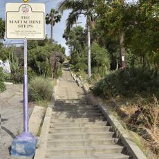
Rio de Los Angeles State Park, State recreation area in Glassell Park, Los Angeles, US.

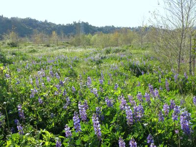
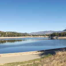
Rio de Los Angeles State Park is a recreation area with 247 acres of restored wetlands stretching along the Los Angeles River. The grounds include sports fields, children's playgrounds, picnic areas, and trails designed for walking, jogging, and cycling.

The site was once Taylor Yard, a freight facility operated by Union Pacific and Southern Pacific railroads starting in the 1920s. After closing in 1985, the industrial land was transformed into a park with restored natural wetlands.

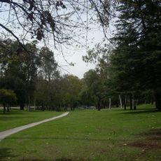
The park serves as a gathering place where neighbors often spend weekends together along the river trails and open fields. Local groups run education programs that help city residents learn about native plants and local wildlife.

The park is easy to explore on foot, by bike, or while jogging with several entry points and parking areas available. Bring water and sun protection as the open fields offer limited shade and exposure to direct sunlight can be intense.

The site supports more than 150 bird species and serves as a refuge for local wildlife within the urban sprawl of the city. This variety makes it a notable spot for watching birds and encountering animals in an urban setting.

The community of curious travelers

AroundUs brings together thousands of curated places, local tips, and hidden gems, enriched daily by 60,000 contributors worldwide.

Start exploring
Location
Inception
2007
Phone
GPS coordinates
34.10000,-118.23600
Latest update
December 9, 2025 18:49
Around this place
Dodger Stadium
United States of America

Dodger Stadium

3 km
Chavez Ravine
United States of America

Chavez Ravine

2.8 km
Dodger Dog
United States of America

Dodger Dog

3.1 km
Arroyo Seco Parkway
United States of America

Arroyo Seco Parkway

3.4 km
Silver Lake Reservoir
United States of America

Silver Lake Reservoir

2.7 km
Heritage Square Museum
United States of America

Heritage Square Museum

2.9 km
Lummis House
United States of America

Lummis House

2.9 km
Garbutt House
United States of America

Garbutt House

2.7 km
Lincoln Heights Jail
United States of America

Lincoln Heights Jail

2.7 km
Neutra VDL Studio and Residences
United States of America

Neutra VDL Studio and Residences

2.3 km
Hale House
United States of America

Hale House

2.9 km
Southwest Museum of the American Indian
United States of America

Southwest Museum of the American Indian

2.8 km
Woman's Building
United States of America

Woman's Building

3.4 km
Neutra Office Building
United States of America

Neutra Office Building

2.1 km
Mattachine Steps
United States of America

Mattachine Steps

2.4 km
Glendale-Hyperion Bridge
United States of America

Glendale-Hyperion Bridge

3.1 km
Van de Kamp Bakery Building
United States of America

Van de Kamp Bakery Building

1.9 km
Avenel Cooperative Housing Project
United States of America

Avenel Cooperative Housing Project

3.1 km
Glassell Park Elementary School
United States of America

Glassell Park Elementary School

465 m
Ernest and Florence Bent Halstead House and Grounds
United States of America

Ernest and Florence Bent Halstead House and Grounds

2.3 km
Lipetz House
United States of America

Lipetz House

3.2 km
Richard Henry Dana Branch
United States of America

Richard Henry Dana Branch

1.7 km
Ziegler Estate
United States of America

Ziegler Estate

2.9 km
Lincoln Heights Branch
United States of America

Lincoln Heights Branch

3.3 km
Silvertop
United States of America

Silvertop

3.1 km
Mount Pleasant House
United States of America

Mount Pleasant House

3 km
Jardín de lotos del Echo Park
United States of America

Jardín de lotos del Echo Park

3.1 km
Cypress Park Branch
United States of America

Cypress Park Branch

851 m
Show the full map
« Rio de Los Angeles State Park - State recreation area in Glassell Park, Los Angeles, US » is provided by Around Us (aroundus.com). Images and texts are derived from Wikimedia project under a Creative Commons license. You are allowed to copy, distribute, and modify copies of this page, under the conditions set by the license, as long as this note is clearly visible.

Discover hidden gems everywhere you go!

From secret cafés to breathtaking viewpoints, skip the crowded tourist spots and find places that match your style. Our app makes it easy with voice search, smart filtering, route optimization, and insider tips from travelers worldwide. Download now for the complete mobile experience.

Around Us App Screenshot

A unique approach to discovering new places

Le Figaro

All the places worth exploring

France Info

A tailor-made excursion in just a few clicks

20 Minutes

Around Us
Travel Guide & Maps
Download

Send to your phone

QR Code
1

Open the camera app on your mobile.

2

Point at the QR code with your camera. A notification will appear.

3

Tap the notification to open the link.