Enable Location

We need your location to show you interesting places around you

Discover nearby places

Find interesting locations and hidden gems around you

Precise directions

Get accurate directions and distances to places

Your location is never shared with other users. It's only used when you tap the location button.

Shirley Ann Place

Log in to your account

Save your favorite places
Create custom travel routes
Rate and review places
Access the full interactive map
Continue with Google
Continue with Apple
Continue with email
By continuing, you accept our Terms and Conditions and our Privacy Policy
Create an account
Add to collection
Map
Suggest a change
Share

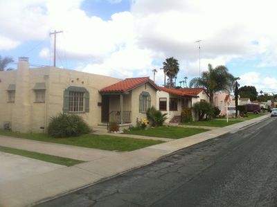
Shirley Ann Place, Historic district in University Heights, San Diego, US.

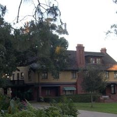
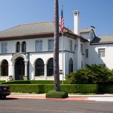
Shirley Ann Place is a residential district comprising 25 houses built within a single block between 1925 and 1949 that showcase Spanish Colonial Revival architectural features throughout. The structures occupy the entire hilltop perimeter of the location, creating a unified streetscape design.

The district emerged after World War I as part of a larger development initiative to address growing middle-class housing demand. Construction unfolded over roughly two decades, reflecting continuous demand during the interwar and immediate postwar period.

The collection of Spanish Colonial Revival bungalows shows how Southern California residents chose to live during the early boom years and what architectural styles appealed to them. These homes reflect the residential tastes of the middle class during this period.

The district lies between Madison Avenue and Monroe Avenue west of Texas Street and can be easily walked through on foot. Strict preservation guidelines protect the architectural features, so visitors should view the houses from the street and respect private properties.

The district also encompasses two additional houses on the south side of Monroe Avenue and includes a small store at the southeast corner of Madison Avenue. These details form an interesting aspect of the street layouts within this area.

Location: California

GPS coordinates: 32.76000,-117.13900

Latest update: December 14, 2025 18:00

Photos
Around this place
Balboa Park
United States of America

Balboa Park

3.2 km
San Diego Zoo
United States of America

San Diego Zoo

2.9 km
San Diego Stadium
United States of America

San Diego Stadium

3.2 km
Snapdragon Stadium
United States of America

Snapdragon Stadium

3.1 km
The Old Globe
United States of America

The Old Globe

3.3 km
San Diego Museum of Art
United States of America

San Diego Museum of Art

3.3 km
San Diego Natural History Museum
United States of America

San Diego Natural History Museum

3.2 km
Zoro Garden Nudist Colony
United States of America

Zoro Garden Nudist Colony

3.3 km
UC San Diego Medical Center, Hillcrest
United States of America

UC San Diego Medical Center, Hillcrest

2.6 km
San Diego Model Railroad Museum
United States of America

San Diego Model Railroad Museum

3.3 km
George W. Marston House
United States of America

George W. Marston House

2.7 km
Timken Museum of Art
United States of America

Timken Museum of Art

3.3 km
Reuben H. Fleet Science Center
United States of America

Reuben H. Fleet Science Center

3.3 km
Balboa Park Gardens
United States of America

Balboa Park Gardens

3.2 km
Dharma Bum Temple
United States of America

Dharma Bum Temple

1.2 km
Museum of Photographic Arts
United States of America

Museum of Photographic Arts

3.3 km
San Diego History Center
United States of America

San Diego History Center

3.3 km
Botanical Building
United States of America

Botanical Building

3.2 km
Switzer Canyon
United States of America

Switzer Canyon

3.1 km
Spanish Village Art Center
United States of America

Spanish Village Art Center

3 km
Bea Evenson Fountain
United States of America

Bea Evenson Fountain

3.3 km
Dryden Historic District
United States of America

Dryden Historic District

1.9 km
All Saints Episcopal Church
United States of America

All Saints Episcopal Church

2.5 km
Georgia Street Bridge-Caltrans Bridge
United States of America

Georgia Street Bridge-Caltrans Bridge

1.4 km
Puente de la Calle Georgia-Puente Caltrans
United States of America

Puente de la Calle Georgia-Puente Caltrans

1.4 km
Casa Coulter
United States of America

Casa Coulter

3.2 km
Teacher Training School Building-San Diego State Normal School
United States of America

Teacher Training School Building-San Diego State Normal School

850 m
Ken Cinema
United States of America

Ken Cinema

2.9 km
Show the full map
Reviews

Visited this place? Tap the stars to rate it and share your experience / photos with the community! Try now! You can cancel it anytime.

« Shirley Ann Place - Historic district in University Heights, San Diego, US » is provided by Around Us (aroundus.com). Images and texts are derived from Wikimedia project under a Creative Commons license. You are allowed to copy, distribute, and modify copies of this page, under the conditions set by the license, as long as this note is clearly visible.

Discover hidden gems everywhere you go!

From secret cafés to breathtaking viewpoints, skip the crowded tourist spots and find places that match your style. Our app makes it easy with voice search, smart filtering, route optimization, and insider tips from travelers worldwide. Download now for the complete mobile experience.

Around Us App Screenshot

A unique approach to discovering new places

Le Figaro

All the places worth exploring

France Info

A tailor-made excursion in just a few clicks

20 Minutes