Enable Location

We need your location to show you interesting places around you

Discover nearby places

Find interesting locations and hidden gems around you

Precise directions

Get accurate directions and distances to places

Your location is never shared with other users. It's only used when you tap the location button.

Switzer Canyon

Log in to your account

Start exploring — it's free

Trusted by 61,622 travelers worldwide

Continue with Google
Continue with Apple
or

We will send you a code to connect

By continuing, you accept our Terms and Conditions and our Privacy Policy

Check your inbox

We've sent a pincode in your inbox. Please enter the code below.

Switzer Canyon

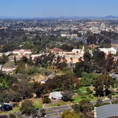
Switzer Canyon, Canyon between North Park and South Park in San Diego, California.

Description

Switzer Canyon is a natural formation that cuts through residential neighborhoods between North Park and South Park, connecting several areas of San Diego. The space features walking and hiking trails that wind through native plants and grass, with multiple entry points throughout the canyon and a central causeway on 30th Street.

History

The area took its name from E.D. Switzer, who established a five-acre property at the canyon's lower end in 1869. The location later served a critical role during an 1887 smallpox outbreak when it became an isolation camp for affected individuals.

Culture

The canyon shapes how San Diego's neighborhoods connect through nature, with trails passing through native plants and green spaces that residents use to move between different parts of the city. Visitors notice how locals value and maintain these paths as shared community spaces.

Practical

Several entry points around the canyon make it easy to start from different neighborhoods and explore at your own pace. Wear comfortable shoes and bring water, as the trails move through uneven ground with native vegetation.

Did you know?

Below the surface of the canyon lies evidence of an 1888 railroad track that once connected the city's early suburbs. This hidden piece of San Diego's development story reveals how neighborhoods were first linked together as the city grew.

Location
GPS coordinates
32.73310,-117.13000
Latest update
December 8, 2025 21:04

AroundUs brings together thousands of curated places, local tips, and hidden gems, enriched daily by 60,000 contributors worldwide. Discover all places nearby (California).

Around this place
Balboa Park
United States of America

Balboa Park

1.4 km
San Diego Zoo
United States of America

San Diego Zoo

2 km
The Old Globe
United States of America

The Old Globe

2.1 km
San Diego Museum of Art
United States of America

San Diego Museum of Art

1.9 km
San Diego Natural History Museum
United States of America

San Diego Natural History Museum

1.6 km
Museum of Us
United States of America

Museum of Us

2.1 km
Zoro Garden Nudist Colony
United States of America

Zoro Garden Nudist Colony

1.7 km
San Diego Hall of Champions
United States of America

San Diego Hall of Champions

2.2 km
San Diego Model Railroad Museum
United States of America

San Diego Model Railroad Museum

1.8 km
Spreckels Organ Pavilion
United States of America

Spreckels Organ Pavilion

1.9 km
Timken Museum of Art
United States of America

Timken Museum of Art

1.8 km
California Quadrangle
United States of America

California Quadrangle

2.1 km
Reuben H. Fleet Science Center
United States of America

Reuben H. Fleet Science Center

1.6 km
Balboa Park Gardens
United States of America

Balboa Park Gardens

1.4 km
Japanese Friendship Garden
United States of America

Japanese Friendship Garden

1.9 km
Mingei International Museum
United States of America

Mingei International Museum

2 km
Museum of Photographic Arts
United States of America

Museum of Photographic Arts

1.7 km
San Diego Art Institute
United States of America

San Diego Art Institute

2 km
San Diego History Center
United States of America

San Diego History Center

1.7 km
Botanical Building
United States of America

Botanical Building

1.8 km
House of Charm
United States of America

House of Charm

2 km
El Prado Complex
United States of America

El Prado Complex

2.1 km
Spanish Village Art Center
United States of America

Spanish Village Art Center

1.6 km
Bea Evenson Fountain
United States of America

Bea Evenson Fountain

1.6 km
Dryden Historic District
United States of America

Dryden Historic District

1.2 km
May S. Marcy Sculpture Garden
United States of America

May S. Marcy Sculpture Garden

2 km
Woman of Tehuantepec
United States of America

Woman of Tehuantepec

1.9 km
El Cid Campeador
United States of America

El Cid Campeador

1.9 km
Show the full map
« Switzer Canyon - Canyon between North Park and South Park in San Diego, California » is provided by Around Us (aroundus.com). Images and texts are derived from Wikimedia project under a Creative Commons license. You are allowed to copy, distribute, and modify copies of this page, under the conditions set by the license, as long as this note is clearly visible.

Discover hidden gems everywhere you go!

From secret cafés to breathtaking viewpoints, skip the crowded tourist spots and find places that match your style. Our app makes it easy with voice search, smart filtering, route optimization, and insider tips from travelers worldwide. Download now for the complete mobile experience.

Around Us App Screenshot

A unique approach to discovering new places

Le Figaro

All the places worth exploring

France Info

A tailor-made excursion in just a few clicks

20 Minutes

Around Us
Travel Guide & Maps
Download

Send to your phone

QR Code
1

Open the camera app on your mobile.

2

Point at the QR code with your camera. A notification will appear.

3

Tap the notification to open the link.