Enable Location

We need your location to show you interesting places around you

Discover nearby places

Find interesting locations and hidden gems around you

Precise directions

Get accurate directions and distances to places

Your location is never shared with other users. It's only used when you tap the location button.

Initial Point of Boundary Between U.S. and Mexico

Log in to your account

Start exploring — it's free

Trusted by 63,019 travelers worldwide

Continue with Google
Continue with Apple
or

We will send you a code to connect

By continuing, you accept our Terms and Conditions and our Privacy Policy

Check your inbox

We've sent a pincode in your inbox. Please enter the code below.

Initial Point of Boundary Between U.S. and Mexico
Discussion Reviews 1 Photos
4.6k Popularity

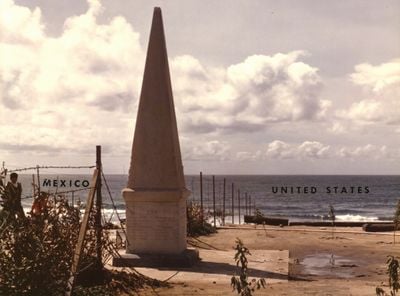
Initial Point of Boundary Between U.S. and Mexico, Boundary marker at Mexico-United States border, San Diego County and Tijuana

A white marble obelisk marks the westernmost point of the international border between Mexico and the United States, standing approximately 20 feet tall. The stone was shipped from New York and serves as the starting point for the entire boundary line.

The monument arrived by ship in 1851 around Cape Horn from New York to mark the boundary starting point defined by the Treaty of Guadalupe Hidalgo. This 1848 treaty established the new border following the war between the United States and Mexico.

The monument displays an inverted acorn on top, symbolizing the California oak and incorporated into the international border designation.

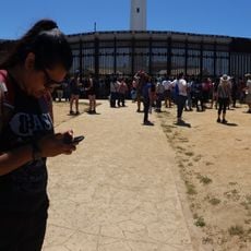
Modern border fencing stands several meters north of the monument, making it primarily accessible from the Mexican side in Playas de Tijuana. The best view is obtained by approaching the stone from the south.

The stone marks the starting point from which the entire boundary line extends eastward to the Gulf of Mexico, a survey spanning roughly 3,100 kilometers. This initial marking system was revolutionary for its era and formed the foundation for all subsequent border demarcations.

The community of curious travelers

AroundUs brings together thousands of curated places, local tips, and hidden gems, enriched daily by 60,000 contributors worldwide.

Start exploring
Location
Location
Part of
Mexico–United States border, Friendship Park
GPS coordinates
32.53445,-117.12279
Latest update
December 10, 2025 20:06
Reviews
Share your experience

No review yet

Discussions
Start a discussion...

No discussion yet

« Initial Point of Boundary Between U.S. and Mexico - Boundary marker at Mexico-United States border, San Diego County and Tijuana » is provided by Around Us (aroundus.com). Images and texts are derived from Wikimedia project under a Creative Commons license. You are allowed to copy, distribute, and modify copies of this page, under the conditions set by the license, as long as this note is clearly visible.

Discover hidden gems everywhere you go!

From secret cafés to breathtaking viewpoints, skip the crowded tourist spots and find places that match your style. Our app makes it easy with voice search, smart filtering, route optimization, and insider tips from travelers worldwide. Download now for the complete mobile experience.

Around Us App Screenshot

A unique approach to discovering new places

Le Figaro

All the places worth exploring

France Info

A tailor-made excursion in just a few clicks

20 Minutes

Around Us
Travel Guide & Maps
Download

Send to your phone

QR Code
1

Open the camera app on your mobile.

2

Point at the QR code with your camera. A notification will appear.

3

Tap the notification to open the link.