Enable Location

We need your location to show you interesting places around you

Discover nearby places

Find interesting locations and hidden gems around you

Precise directions

Get accurate directions and distances to places

Your location is never shared with other users. It's only used when you tap the location button.

Laguna Niguel Regional Park

Log in to your account

Start exploring — it's free

Trusted by 61,993 travelers worldwide

Continue with Google
Continue with Apple
or

We will send you a code to connect

By continuing, you accept our Terms and Conditions and our Privacy Policy

Check your inbox

We've sent a pincode in your inbox. Please enter the code below.

Laguna Niguel Regional Park

Laguna Niguel Regional Park, Regional park in Laguna Niguel, California.

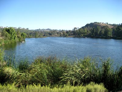
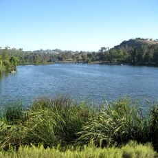
Laguna Niguel Regional Park is a 227-acre park in California featuring a 44-acre lake surrounded by recreational facilities. The grounds include sports courts, picnic areas, playgrounds, and an extensive network of walking trails that connect different sections.

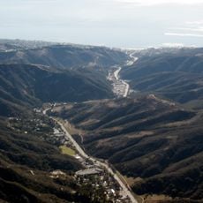
The park was established in 1973 as undeveloped land was transformed into a recreational space for Orange County's growing population. This development reflected the area's expansion during that period and responded to increasing demand for public spaces.

The amphitheater hosts concerts and community events where local artists perform under the open sky. Visitors experience the social rhythm of the area and see how residents gather for outdoor entertainment throughout the year.

The park has extended hours during warmer months and is accessible from multiple entry points with ample parking throughout the grounds. Plan your visit based on the season and expected activities, as afternoon sun can be strong but shaded areas are available throughout the park.

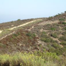
Kite Hill offers a dedicated space for remote-controlled glider enthusiasts to fly their models in an open area. The lake supports year-round fishing, with additional trout releases during winter months to enhance fishing opportunities for visitors.

The community of curious travelers

AroundUs brings together thousands of curated places, local tips, and hidden gems, enriched daily by 60,000 contributors worldwide.

Start exploring
Location
Inception
1973
GPS coordinates
33.54720,-117.70700
Latest update
December 12, 2025 17:47
Around this place
Mission San Juan Capistrano
United States of America

Mission San Juan Capistrano

6.4 km
Doheny State Beach
United States of America

Doheny State Beach

10 km
Mission Basilica San Juan Capistrano
United States of America

Mission Basilica San Juan Capistrano

6.2 km
Chet Holifield Federal Building
United States of America

Chet Holifield Federal Building

1.7 km
Laguna Woods Village
United States of America

Laguna Woods Village

7.4 km
Hangover House
United States of America

Hangover House

5.6 km
El Adobe de Capistrano
United States of America

El Adobe de Capistrano

6.7 km
Laguna Canyon
United States of America

Laguna Canyon

5.8 km
Laguna Coast Wilderness Park
United States of America

Laguna Coast Wilderness Park

7.1 km
Aliso and Wood Canyons Regional Park
United States of America

Aliso and Wood Canyons Regional Park

2.9 km
Laguna Art Museum
United States of America

Laguna Art Museum

7.5 km
Pretend City Children's Museum
United States of America

Pretend City Children's Museum

11 km
Aliso Canyon
United States of America

Aliso Canyon

5.9 km
Los Rios Street Historic District
United States of America

Los Rios Street Historic District

6.5 km
Laguna Niguel Lake
United States of America

Laguna Niguel Lake

293 m
Jose Serrano Adobe
United States of America

Jose Serrano Adobe

10.7 km
Strand Beach Funicular
United States of America

Strand Beach Funicular

8.7 km
St. Francis by-the-Sea American Catholic Church
United States of America

St. Francis by-the-Sea American Catholic Church

7 km
Via Murillo
United States of America

Via Murillo

10.3 km
Richard Egan House
United States of America

Richard Egan House

6.6 km
Esslinger Building
United States of America

Esslinger Building

6.8 km
Frank A. Forster House
United States of America

Frank A. Forster House

6.9 km
Aliso Beach
United States of America

Aliso Beach

5.9 km
Roger Y. Williams House
United States of America

Roger Y. Williams House

3.9 km
Dawson Cole Fine Art
United States of America

Dawson Cole Fine Art

7 km
Dana Point Cave
United States of America

Dana Point Cave

9.7 km
Mission Viejo Library
United States of America

Mission Viejo Library

7 km
El Toro Branch Library
United States of America

El Toro Branch Library

8.1 km
Show the full map
« Laguna Niguel Regional Park - Regional park in Laguna Niguel, California » is provided by Around Us (aroundus.com). Images and texts are derived from Wikimedia project under a Creative Commons license. You are allowed to copy, distribute, and modify copies of this page, under the conditions set by the license, as long as this note is clearly visible.

Discover hidden gems everywhere you go!

From secret cafés to breathtaking viewpoints, skip the crowded tourist spots and find places that match your style. Our app makes it easy with voice search, smart filtering, route optimization, and insider tips from travelers worldwide. Download now for the complete mobile experience.

Around Us App Screenshot

A unique approach to discovering new places

Le Figaro

All the places worth exploring

France Info

A tailor-made excursion in just a few clicks

20 Minutes

Around Us
Travel Guide & Maps
Download

Send to your phone

QR Code
1

Open the camera app on your mobile.

2

Point at the QR code with your camera. A notification will appear.

3

Tap the notification to open the link.