Chest opened
+${chestReward.xp} XP
Explorer
NOUVEAU ×${chestReward.collectible.quantity}
tapez pour fermer
Chest locked

Open chests in the app

Around Us is built for your phone — chests unlock when you walk, explore and capture nearby places.

Enable Location

We need your location to show you interesting places around you

Discover nearby places

Find interesting locations and hidden gems around you

Precise directions

Get accurate directions and distances to places

Your location is never shared with other users. It's only used when you tap the location button.

Chino Hills

Log in to your account

Start exploring — it's free

Trusted by 72,931 travelers worldwide

Continue with Google
Continue with Apple
or

We will send you a code to connect

By continuing, you accept our Terms and Conditions and our Privacy Policy

Check your inbox

We've sent a pincode in your inbox. Please enter the code below.

Chino Hills
Discussion Reviews 1 Photos
19.6k Popularity

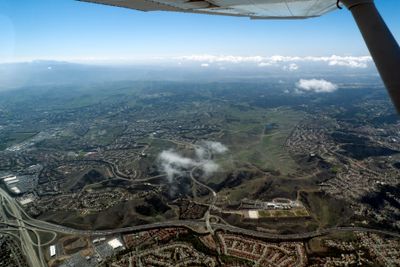
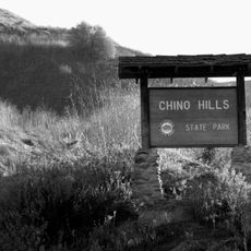
Chino Hills, Mountain range at Orange, Los Angeles, and San Bernardino counties border, California, US

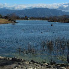
Chino Hills is a mountain range spanning three California counties where Orange, Los Angeles, and San Bernardino meet. The terrain features chaparral shrubland and oak woodlands, with the highest point reaching about 1,600 feet (485 meters).

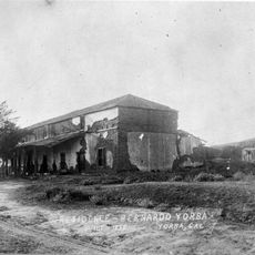
The Tongva and Gabrieliño Native Americans established seasonal camps throughout these hills before Spanish colonizers arrived in the 1700s. The landscape was then converted into grazing grounds for mission cattle herds.

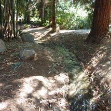
The hills serve as a living wildlife corridor where deer, coyotes, and numerous bird species move freely between fragmented habitats. This passage allows animals to travel across the landscape despite surrounding urban development.

Carbon Canyon Road is the main paved passage through the range, providing access between different areas of Southern California. This route offers the most direct way to traverse the hills without requiring unpaved roads or hiking trails.

A 5.4 magnitude earthquake originated here in 2008 and was felt across facilities throughout Southern California. This seismic event revealed the region's geological activity beneath the surface.

The community of curious travelers

AroundUs brings together thousands of curated places, local tips, and hidden gems, enriched daily by 60,000 contributors worldwide.

Start exploring
Location
Elevation above the sea
485 m
GPS coordinates
33.93390,-117.73780
Latest update
December 7, 2025 10:07
Around this place
Richard Nixon Presidential Library and Museum
United States of America

Richard Nixon Presidential Library and Museum

9 km
BAPS Shri Swaminarayan Mandir Chino Hills
United States of America

BAPS Shri Swaminarayan Mandir Chino Hills

6.1 km
Planes of Fame Air Museum
United States of America

Planes of Fame Air Museum

10.5 km
USA Yanks Air Museum
United States of America

USA Yanks Air Museum

9.8 km
Birthplace of Richard Nixon
United States of America

Birthplace of Richard Nixon

8.9 km
Chino Hills State Park
United States of America

Chino Hills State Park

4 km
Phillips Mansion
United States of America

Phillips Mansion

14.6 km
Pomona Fox Theater
United States of America

Pomona Fox Theater

13.7 km
Orange County Zoo
United States of America

Orange County Zoo

15.4 km
Fullerton Arboretum
United States of America

Fullerton Arboretum

14.4 km
Yorba Hacienda
United States of America

Yorba Hacienda

8.7 km
Prado Regional Park
United States of America

Prado Regional Park

8.6 km
United States of America

Santa Ana Canyon

9.2 km
Carbon Canyon Regional Park
United States of America

Carbon Canyon Regional Park

9.3 km
A. S. Bradford House
United States of America

A. S. Bradford House

12.7 km
Baitul Hameed Mosque
United States of America

Baitul Hameed Mosque

11.8 km
Irvine Park
United States of America

Irvine Park

15.5 km
Lincoln Park Historic District
United States of America

Lincoln Park Historic District

15.2 km
George Key Ranch
United States of America

George Key Ranch

12.7 km
La Casa Alvarado
United States of America

La Casa Alvarado

15.7 km
Pomona City Stables
United States of America

Pomona City Stables

14.1 km
Yorba-Slaughter Adobe
United States of America

Yorba-Slaughter Adobe

6.9 km
Brea City Hall and Park
United States of America

Brea City Hall and Park

15.3 km
Category:Fender Guitar Factory museum
United States of America

Category:Fender Guitar Factory museum

13.5 km
Moyse Building
United States of America

Moyse Building

10 km
Olinda Oil Museum
United States of America

Olinda Oil Museum

9.2 km
Camelot Golfland Family Fun Center
United States of America

Camelot Golfland Family Fun Center

14 km
Pomona Public Library
United States of America

Pomona Public Library

13.4 km
Show the full map
Reviews
Share your experience

No review yet

Discussions
Start a discussion...

No discussion yet

« Chino Hills - Mountain range at Orange, Los Angeles, and San Bernardino counties border, California, US » is provided by Around Us (aroundus.com). Images and texts are derived from Wikimedia project under a Creative Commons license. You are allowed to copy, distribute, and modify copies of this page, under the conditions set by the license, as long as this note is clearly visible.

Discover hidden gems everywhere you go!

From secret cafés to breathtaking viewpoints, skip the crowded tourist spots and find places that match your style. Our app makes it easy with voice search, smart filtering, route optimization, and insider tips from travelers worldwide. Download now for the complete mobile experience.

Around Us App Screenshot

A unique approach to discovering new places

Le Figaro

All the places worth exploring

France Info

A tailor-made excursion in just a few clicks

20 Minutes

Around Us
Travel Guide & Maps
Download

Send to your phone

QR Code
1

Open the camera app on your mobile.

2

Point at the QR code with your camera. A notification will appear.

3

Tap the notification to open the link.