Enable Location

We need your location to show you interesting places around you

Discover nearby places

Find interesting locations and hidden gems around you

Precise directions

Get accurate directions and distances to places

Your location is never shared with other users. It's only used when you tap the location button.

Log in to your account

Start exploring — it's free

Trusted by 67,548 travelers worldwide

Continue with Google
Continue with Apple
or

We will send you a code to connect

By continuing, you accept our Terms and Conditions and our Privacy Policy

Check your inbox

We've sent a pincode in your inbox. Please enter the code below.

Coyote Mountains Wilderness
Discussion Reviews Photo
1.5k Popularity

Coyote Mountains Wilderness, Protected wilderness area in Pima County, Arizona.

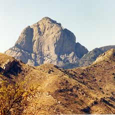
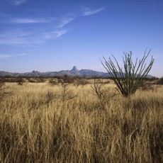
Coyote Mountains Wilderness is a protected desert area in Arizona with rounded rock formations and steep cliff faces scattered across the landscape. Large open canyons run through the terrain, creating dramatic natural channels carved by water over time.

The Bureau of Land Management designated this area as protected wilderness in the 1990s as part of broader conservation efforts in the Sonoran Desert. This protection came from initiatives to preserve the region's unique desert ecosystems and natural features.

The land surrounding the wilderness requires access permission from private landholders or the Tohono O'odham Nation, reflecting complex land management relationships.

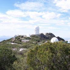
The area is reachable from Highway 86 west of Tucson heading toward Kitt Peak Observatory, then traveling south on Highway 286. Visitors need to understand that access crosses private land or Tohono O'odham Nation territory and requires permission in advance.

The highest point, Coyote Peak, rises above 2,100 feet (640 meters) and remains visible from the surrounding Altar Valley plains below. This visibility makes the ridge a natural landmark for travelers crossing the region.

The community of curious travelers

AroundUs brings together thousands of curated places, local tips, and hidden gems, enriched daily by 60,000 contributors worldwide.

Start exploring
Location
GPS coordinates
31.98980,-111.52100
Latest update
December 14, 2025 14:44
Around this place
Kitt Peak National Observatory
United States of America

Kitt Peak National Observatory

8 km
Baboquivari Peak Wilderness
United States of America

Baboquivari Peak Wilderness

22.7 km
Dark Energy Spectroscopic Instrument
United States of America

Dark Energy Spectroscopic Instrument

8 km
Kitt Peak
United States of America

Kitt Peak

7.9 km
McMath–Pierce Solar Telescope
United States of America

McMath–Pierce Solar Telescope

7.8 km
Buenos Aires National Wildlife Refuge
United States of America

Buenos Aires National Wildlife Refuge

39 km
Nicholas U. Mayall Telescope
United States of America

Nicholas U. Mayall Telescope

8 km
WIYN Telescope
United States of America

WIYN Telescope

8.4 km
ARO 12m Radio Telescope
United States of America

ARO 12m Radio Telescope

9.8 km
Michigan-Dartmouth-MIT Observatory
United States of America

Michigan-Dartmouth-MIT Observatory

9.9 km
Bok Telescope
United States of America

Bok Telescope

8 km
United States of America

Fresnal Canyon

21.3 km
United States of America

Etoi Ki

40.3 km
McGraw-Hill Telescope
United States of America

McGraw-Hill Telescope

10.1 km
Hiltner 2.4m Telescope
United States of America

Hiltner 2.4m Telescope

9.9 km
Red Hills Visitor Center
United States of America

Red Hills Visitor Center

42.4 km
United States of America

Kitt Peak VLBA station

9.4 km
United States of America

Kitt Peak-Bok observatory

8 km
SARA-KP
United States of America

SARA-KP

8.1 km
United States of America

Rocky Point

25.9 km
United States of America

Desert Discovery Nature Trail

42.1 km
United States of America

Tucson Mountain County Park

43 km
United States of America

Santa Margarita Ranch

35.3 km
United States of America

Brown Canyon Arch

24.5 km
United States of America

Scenic viewpoint

7.8 km
United States of America

Scenic viewpoint, rest area

10.9 km
United States of America

Scenic viewpoint, rest area

8.7 km
United States of America

Jagiar Canyon Water Falls

23.1 km
Show the full map
Reviews
Share your experience

No review yet

Discussions
Start a discussion...

No discussion yet

« Coyote Mountains Wilderness - Protected wilderness area in Pima County, Arizona » is provided by Around Us (aroundus.com). Images and texts are derived from Wikimedia project under a Creative Commons license. You are allowed to copy, distribute, and modify copies of this page, under the conditions set by the license, as long as this note is clearly visible.

Discover hidden gems everywhere you go!

From secret cafés to breathtaking viewpoints, skip the crowded tourist spots and find places that match your style. Our app makes it easy with voice search, smart filtering, route optimization, and insider tips from travelers worldwide. Download now for the complete mobile experience.

Around Us App Screenshot

A unique approach to discovering new places

Le Figaro

All the places worth exploring

France Info

A tailor-made excursion in just a few clicks

20 Minutes

Around Us
Travel Guide & Maps
Download

Send to your phone

QR Code
1

Open the camera app on your mobile.

2

Point at the QR code with your camera. A notification will appear.

3

Tap the notification to open the link.