Baboquivari Peak Wilderness

Log in to your account

AroundUs is a community-driven map of interesting places, built by curious explorers like you. It grows with every review, story, and photo you share.
Connect to save your favorite spots, contribute locations, and create personalized routes.
Continue with Google
Continue with Apple
Continue with X
Continue with Facebook
Continue with email
By continuing, you accept our Terms and Conditions and our Privacy Policy
Create an account
Add to collection
Map
Suggest a change
Share

Baboquivari Peak Wilderness, Protected wilderness area in Baboquivari Mountains, Arizona.

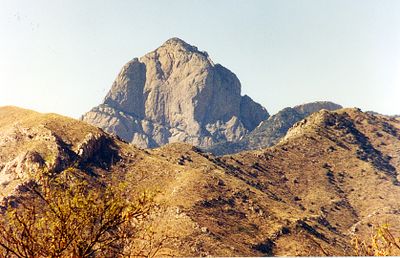
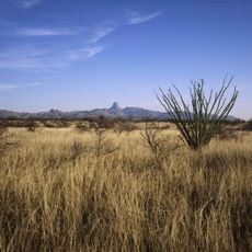
Baboquivari Peak Wilderness is a protected mountain region with rocky terrain and elevations ranging from 4,500 feet to 7,730 feet at the summit. The area spans approximately 2,065 acres and features steep ridges, narrow canyons, and scattered desert brush mixed with stands of oak and walnut.

Congress designated this region as a wilderness area in 1990, establishing it as Arizona's smallest protected wilderness. This protection recognized the ecological and cultural importance of the mountain and its surrounding landscape.

The peak holds deep spiritual significance for the Tohono O'odham people, who believe their creator I'itoi dwells in a cave beneath the summit. This sacred connection shapes how the mountain is understood and respected by those with long roots in the region.

Reaching the summit requires advanced climbing skills and technical gear, as the upper sections demand class 5 rock climbing expertise. Visitors less experienced with rock climbing can explore the lower elevations where trails are less demanding and offer easier access.

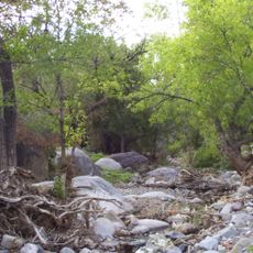
The region hosts diverse wildlife including mountain lions, golden eagles, coati, and rare plant species like oak and walnut trees that thrive in the transition between desert and mountain forest. This mix of species makes it a refuge for animals that cannot survive in the surrounding lower elevations.

Location: Pima County

Elevation above the sea: 2,357 m

GPS coordinates: 31.79147,-111.57566

Latest update: December 8, 2025 13:43

Photos
Around this place
Titan Missile Museum
United States of America

Titan Missile Museum

55.9 km
Kitt Peak National Observatory
United States of America

Kitt Peak National Observatory

18.7 km
Madera Canyon
United States of America

Madera Canyon

60.3 km
Tumacácori National Historical Park
United States of America

Tumacácori National Historical Park

55.6 km
VERITAS
United States of America

VERITAS

60.5 km
Dark Energy Spectroscopic Instrument
United States of America

Dark Energy Spectroscopic Instrument

18.7 km
Kitt Peak
United States of America

Kitt Peak

19.4 km
McMath–Pierce Solar Telescope
United States of America

McMath–Pierce Solar Telescope

18.7 km
Tumacácori Mission
United States of America

Tumacácori Mission

55.6 km
Buenos Aires National Wildlife Refuge
United States of America

Buenos Aires National Wildlife Refuge

20.3 km
Nicholas U. Mayall Telescope
United States of America

Nicholas U. Mayall Telescope

19.3 km
Tubac Presidio State Historic Park
United States of America

Tubac Presidio State Historic Park

54 km
Tucson ring meteorite
United States of America

Tucson ring meteorite

58 km
Tubac Presidio
United States of America

Tubac Presidio

54 km
WIYN Telescope
United States of America

WIYN Telescope

18.6 km
ARO 12m Radio Telescope
United States of America

ARO 12m Radio Telescope

18.4 km
Michigan-Dartmouth-MIT Observatory
United States of America

Michigan-Dartmouth-MIT Observatory

18.2 km
Black Mountain
United States of America

Black Mountain

58.9 km
Bok Telescope
United States of America

Bok Telescope

19.2 km
Arivaca Schoolhouse
United States of America

Arivaca Schoolhouse

33.4 km
Old Tubac Schoolhouse
United States of America

Old Tubac Schoolhouse

53.9 km
San Ignacio Golf Club
United States of America

San Ignacio Golf Club

52.9 km
Tubac Presidio State Historic Park
United States of America

Tubac Presidio State Historic Park

54 km
Tumacácori Museum
United States of America

Tumacácori Museum

55.6 km
McGraw-Hill Telescope
United States of America

McGraw-Hill Telescope

18.1 km
Hiltner 2.4m Telescope
United States of America

Hiltner 2.4m Telescope

18.2 km
Otero Hall
United States of America

Otero Hall

54 km
SARA-KP
United States of America

SARA-KP

19 km
Show the full map
Reviews

Visited this place? Tap the stars to rate it and share your experience / photos with the community! Try now! You can cancel it anytime.

« Baboquivari Peak Wilderness - Protected wilderness area in Baboquivari Mountains, Arizona » is provided by Around Us (aroundus.com). Images and texts are derived from Wikimedia project under a Creative Commons license. You are allowed to copy, distribute, and modify copies of this page, under the conditions set by the license, as long as this note is clearly visible.

Discover hidden gems everywhere you go!

From secret cafés to breathtaking viewpoints, skip the crowded tourist spots and find places that match your style. Our app makes it easy with voice search, smart filtering, route optimization, and insider tips from travelers worldwide. Download now for the complete mobile experience.

Around Us App Screenshot

A unique approach to discovering new places

Le Figaro

All the places worth exploring

France Info

A tailor-made excursion in just a few clicks

20 Minutes