Log in to your account

AroundUs is a community-driven map of interesting places, built by curious explorers like you. It grows with every review, story, and photo you share.
Connect to save your favorite spots, contribute locations, and create personalized routes.
Continue with Google
Continue with Apple
Continue with X
Continue with Facebook
Continue with email
By continuing, you accept our Terms and Conditions and our Privacy Policy
Create an account
Add to collection
Map
Suggest a change
Share

Hellsgate Wilderness, Protected wilderness area in Gila County, Arizona.

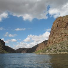
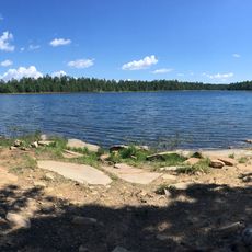
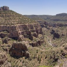
Hellsgate Wilderness is a protected wilderness area in Gila County covering more than 37,000 acres and defined by deep canyons. The centerpiece is a roughly 1,000-foot gorge carved by Tonto Creek through the Mogollon Rim.

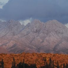
The Salado culture inhabited the southern section until around the 14th century and practiced agriculture there. Environmental shifts eventually led them to abandon the region.

The name comes from the dramatic gorge carved by Tonto Creek through the Mogollon Rim. Native peoples hunted across this land for generations before moving to reservations in the late 1800s.

Most roads require a four-wheel-drive vehicle, especially Forest Road 133, to reach the area. Hikers and backpackers can use Trail 37, which offers several entry points.

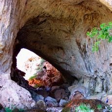
In 1927, an airplane carrying MGM's famous mascot Leo the Lion made an emergency landing nearby. The event left its mark on local history, and the place was later named Leo Canyon.

Location: Arizona

GPS coordinates: 34.19140,-111.12900

Latest update: December 11, 2025 18:07

Photos
Around this place
Canyon Lake
United States of America

Canyon Lake

77.5 km
Four Peaks
United States of America

Four Peaks

59.3 km
Tonto Natural Bridge
United States of America

Tonto Natural Bridge

33.4 km
Blue Ridge Reservoir
United States of America

Blue Ridge Reservoir

39.3 km
Skeleton Cave
United States of America

Skeleton Cave

71.4 km
Willow Springs Lake
United States of America

Willow Springs Lake

26.6 km
Discovery Channel Telescope
United States of America

Discovery Channel Telescope

67.2 km
Wet Beaver Wilderness
United States of America

Wet Beaver Wilderness

50 km
Salt River Canyon Wilderness
United States of America

Salt River Canyon Wilderness

66.4 km
Childs-Irving Hydroelectric Facilities
United States of America

Childs-Irving Hydroelectric Facilities

55.3 km
Sears-Kay Ruin
United States of America

Sears-Kay Ruin

41.2 km
V-Bar-V Heritage Site
United States of America

V-Bar-V Heritage Site

75.3 km
Mormon Flat Dam
United States of America

Mormon Flat Dam

76.6 km
Fossil Springs Wilderness
United States of America

Fossil Springs Wilderness

47.6 km
Roosevelt Lake Bridge
United States of America

Roosevelt Lake Bridge

57.7 km
Verde River Sheep Bridge
United States of America

Verde River Sheep Bridge

54.8 km
Sierra Ancha Wilderness
United States of America

Sierra Ancha Wilderness

47.2 km
Tonto Natural Bridge State Park
United States of America

Tonto Natural Bridge State Park

33.4 km
Fossil Creek Bridge
United States of America

Fossil Creek Bridge

51.2 km
Beaver Creek Ranger Station
United States of America

Beaver Creek Ranger Station

75.7 km
Strawberry Schoolhouse
United States of America

Strawberry Schoolhouse

43.1 km
Clear Creek Church
United States of America

Clear Creek Church

74.2 km
Pleasant Valley Ranger Station
United States of America

Pleasant Valley Ranger Station

19.3 km
Tonto National Monument Visitor Center
United States of America

Tonto National Monument Visitor Center

60.8 km
Verde River Golf and Social Club
United States of America

Verde River Golf and Social Club

72.1 km
Boulder Creek Bridge
United States of America

Boulder Creek Bridge

78.1 km
Aztec Peak Lookout
United States of America

Aztec Peak Lookout

46.9 km
Moqui Lookout
United States of America

Moqui Lookout

41.7 km
Show the full map
Reviews

Visited this place? Tap the stars to rate it and share your experience / photos with the community! Try now! You can cancel it anytime.

« Hellsgate Wilderness - Protected wilderness area in Gila County, Arizona » is provided by Around Us (aroundus.com). Images and texts are derived from Wikimedia project under a Creative Commons license. You are allowed to copy, distribute, and modify copies of this page, under the conditions set by the license, as long as this note is clearly visible.

Discover hidden gems everywhere you go!

From secret cafés to breathtaking viewpoints, skip the crowded tourist spots and find places that match your style. Our app makes it easy with voice search, smart filtering, route optimization, and insider tips from travelers worldwide. Download now for the complete mobile experience.

Around Us App Screenshot

A unique approach to discovering new places

Le Figaro

All the places worth exploring

France Info

A tailor-made excursion in just a few clicks

20 Minutes