Chest opened
+${chestReward.xp} XP
Explorer
NOUVEAU ×${chestReward.collectible.quantity}
tapez pour fermer
Chest locked

Open chests in the app

Around Us is built for your phone — chests unlock when you walk, explore and capture nearby places.

Enable Location

We need your location to show you interesting places around you

Discover nearby places

Find interesting locations and hidden gems around you

Precise directions

Get accurate directions and distances to places

Your location is never shared with other users. It's only used when you tap the location button.

Woods Canyon Lake

Log in to your account

Start exploring — it's free

Trusted by 72,983 travelers worldwide

Continue with Google
Continue with Apple
or

We will send you a code to connect

By continuing, you accept our Terms and Conditions and our Privacy Policy

Check your inbox

We've sent a pincode in your inbox. Please enter the code below.

Woods Canyon Lake
Discussion Reviews 1 Photos
11.8k Popularity

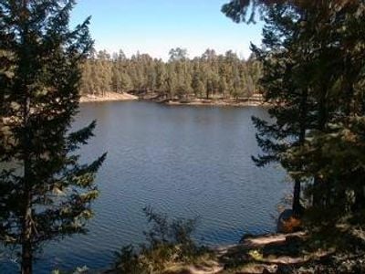
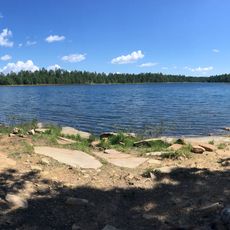
Woods Canyon Lake, Recreational lake in Apache-Sitgreaves National Forest, Arizona.

Woods Canyon Lake is a mountain lake in Apache-Sitgreaves National Forest situated at high elevation surrounded by dense pine forests and rocky terrain. The water sits near the Forest Lakes community and serves as a center for outdoor activities in the area.

This lake developed as a recreation destination in the 1950s for Arizona families seeking outdoor escape and fishing opportunities. Forest Service stewardship has maintained it as a valued recreation area for the surrounding communities over the decades.

The area incorporates educational Forest Service ranger programs during weekends, teaching visitors about local wildlife and environmental conservation.

Visitors can rent boats, purchase fishing gear, and find basic supplies at the local store, which typically operates during the warm months. Camping facilities and simple amenities are available nearby for those planning overnight stays.

The lake sits atop the Mogollon Rim, a dramatic cliff formation that creates distinct growing conditions for forest plants and wild elk and deer populations. This elevation makes the surrounding forest notably cooler and wetter than the desert landscape far below.

The community of curious travelers

AroundUs brings together thousands of curated places, local tips, and hidden gems, enriched daily by 60,000 contributors worldwide.

Start exploring
Location
GPS coordinates
34.33944,-110.95250
Latest update
December 7, 2025 20:48
Around this place
Meteor Crater
United States of America

Meteor Crater

76.9 km
Chevelon Creek Bridge
United States of America

Chevelon Creek Bridge

75.7 km
Tonto Natural Bridge
United States of America

Tonto Natural Bridge

46.4 km
Meteor Crater Natural Landmark
United States of America

Meteor Crater Natural Landmark

76.9 km
Blue Ridge Reservoir
United States of America

Blue Ridge Reservoir

32.1 km
Willow Springs Lake
United States of America

Willow Springs Lake

8.5 km
Discovery Channel Telescope
United States of America

Discovery Channel Telescope

62.3 km
Wet Beaver Wilderness
United States of America

Wet Beaver Wilderness

64.2 km
Meteor Crater Visitor Center
United States of America

Meteor Crater Visitor Center

77.5 km
Salt River Canyon Wilderness
United States of America

Salt River Canyon Wilderness

77.3 km
Childs-Irving Hydroelectric Facilities
United States of America

Childs-Irving Hydroelectric Facilities

68.6 km
Sears-Kay Ruin
United States of America

Sears-Kay Ruin

63 km
V-Bar-V Heritage Site
United States of America

V-Bar-V Heritage Site

78.9 km
Fossil Springs Wilderness
United States of America

Fossil Springs Wilderness

55.6 km
Roosevelt Lake Bridge
United States of America

Roosevelt Lake Bridge

76.5 km
Verde River Sheep Bridge
United States of America

Verde River Sheep Bridge

75.4 km
Sierra Ancha Wilderness
United States of America

Sierra Ancha Wilderness

58 km
Tonto Natural Bridge State Park
United States of America

Tonto Natural Bridge State Park

46.4 km
Fossil Creek Bridge
United States of America

Fossil Creek Bridge

62.5 km
Cedar Canyon Bridge
United States of America

Cedar Canyon Bridge

75.2 km
Strawberry Schoolhouse
United States of America

Strawberry Schoolhouse

52.6 km
Corduroy Creek Bridge
United States of America

Corduroy Creek Bridge

78 km
Pleasant Valley Ranger Station
United States of America

Pleasant Valley Ranger Station

25 km
Tonto National Monument Visitor Center
United States of America

Tonto National Monument Visitor Center

78.7 km
American Astronaut Wall of Fame
United States of America

American Astronaut Wall of Fame

77.5 km
Aztec Peak Lookout
United States of America

Aztec Peak Lookout

58.8 km
Moqui Lookout
United States of America

Moqui Lookout

32 km
Apache Maid Lookout
United States of America

Apache Maid Lookout

69.7 km
Show the full map
Reviews
Share your experience

No review yet

Discussions
Start a discussion...

No discussion yet

« Woods Canyon Lake - Recreational lake in Apache-Sitgreaves National Forest, Arizona » is provided by Around Us (aroundus.com). Images and texts are derived from Wikimedia project under a Creative Commons license. You are allowed to copy, distribute, and modify copies of this page, under the conditions set by the license, as long as this note is clearly visible.

Discover hidden gems everywhere you go!

From secret cafés to breathtaking viewpoints, skip the crowded tourist spots and find places that match your style. Our app makes it easy with voice search, smart filtering, route optimization, and insider tips from travelers worldwide. Download now for the complete mobile experience.

Around Us App Screenshot

A unique approach to discovering new places

Le Figaro

All the places worth exploring

France Info

A tailor-made excursion in just a few clicks

20 Minutes

Around Us
Travel Guide & Maps
Download

Send to your phone

QR Code
1

Open the camera app on your mobile.

2

Point at the QR code with your camera. A notification will appear.

3

Tap the notification to open the link.