Enable Location

We need your location to show you interesting places around you

Discover nearby places

Find interesting locations and hidden gems around you

Precise directions

Get accurate directions and distances to places

Your location is never shared with other users. It's only used when you tap the location button.

White Sands V-2 Launching Site

Log in to your account

Start exploring — it's free

Trusted by 62,546 travelers worldwide

Continue with Google
Continue with Apple
or

We will send you a code to connect

By continuing, you accept our Terms and Conditions and our Privacy Policy

Check your inbox

We've sent a pincode in your inbox. Please enter the code below.

White Sands V-2 Launching Site, Historic rocket launch complex in Doña Ana County, United States

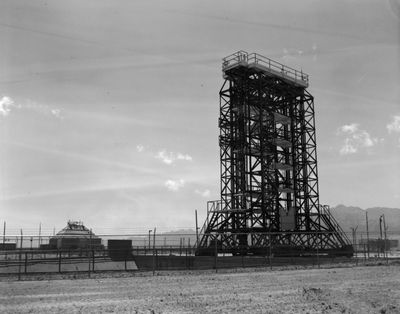
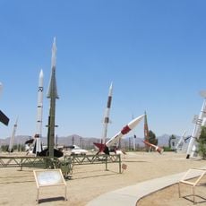
The White Sands V-2 Launching Site is a historic rocket testing facility located in the New Mexico desert. The complex includes a 75-foot steel gantry, a concrete observation tower with 10-foot-thick protective walls, and adjustable launch platforms spread across roughly 10 acres.

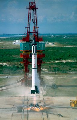
Between 1946 and 1951, scientists conducted 67 V-2 rocket launches at this site using captured German technology from World War II. These test flights established the foundation for American spaceflight development in the postwar era.

The complex earned National Historic Landmark status in 1985, marking its role in advancing American space exploration and military rocket development.

The site is located within White Sands Missile Range, so advance permission is required to visit the area. Check ahead with the relevant authorities about access conditions and visiting requirements before planning your trip.

The observation tower contains specialized viewing portals built into its pyramidal concrete roof, allowing personnel to monitor launches from a protected vantage point. This clever design protected observers from blast and debris during test flights.

The community of curious travelers

AroundUs brings together thousands of curated places, local tips, and hidden gems, enriched daily by 60,000 contributors worldwide.

Start exploring
Location
GPS coordinates
32.40111,-106.37778
Latest update
December 8, 2025 20:01
Around this place
Aggie Memorial Stadium
United States of America

Aggie Memorial Stadium

36.7 km
Organ Needle
United States of America

Organ Needle

18.4 km
San Andres National Wildlife Refuge
United States of America

San Andres National Wildlife Refuge

34.4 km
San Augustin Mountains
United States of America

San Augustin Mountains

17.6 km
Mesilla Plaza
United States of America

Mesilla Plaza

41.7 km
Rio Grande Theatre
United States of America

Rio Grande Theatre

39 km
Mesilla Valley Bosque State Park
United States of America

Mesilla Valley Bosque State Park

36.2 km
Cathedral of the Immaculate Heart of Mary
United States of America

Cathedral of the Immaculate Heart of Mary

38.3 km
Thomas Branigan Memorial Library
United States of America

Thomas Branigan Memorial Library

38.8 km
Wells Fargo Tower
United States of America

Wells Fargo Tower

39.2 km
Jornada Biosphere Reserve
United States of America

Jornada Biosphere Reserve

7.6 km
Green Bridge
United States of America

Green Bridge

34.2 km
Goddard Hall
United States of America

Goddard Hall

37.8 km
Alameda-Depot Historic District
United States of America

Alameda-Depot Historic District

39.4 km
Mesilla Park Elementary School
United States of America

Mesilla Park Elementary School

39.4 km
Phillips Chapel CME Church
United States of America

Phillips Chapel CME Church

38.4 km
Foster Hall
United States of America

Foster Hall

37.7 km
L.B. Bentley General Merchandise
United States of America

L.B. Bentley General Merchandise

21 km
Nason House
United States of America

Nason House

37.8 km
Barela-Reynolds House
United States of America

Barela-Reynolds House

41.7 km
Frank and Amelia Jones House
United States of America

Frank and Amelia Jones House

42.8 km
Hadley-Ludwick House
United States of America

Hadley-Ludwick House

38.4 km
Nestor Armijo House
United States of America

Nestor Armijo House

39 km
Dona Ana Village Historic District
United States of America

Dona Ana Village Historic District

41.2 km
Mesilla Park Historic District
United States of America

Mesilla Park Historic District

39.6 km
White Sands Missile Range Museum
United States of America

White Sands Missile Range Museum

9.6 km
Old Doña Ana County Courthouse
United States of America

Old Doña Ana County Courthouse

39.2 km
Branigan Cultural Center
United States of America

Branigan Cultural Center

39.1 km
Show the full map
« White Sands V-2 Launching Site - Historic rocket launch complex in Doña Ana County, United States » is provided by Around Us (aroundus.com). Images and texts are derived from Wikimedia project under a Creative Commons license. You are allowed to copy, distribute, and modify copies of this page, under the conditions set by the license, as long as this note is clearly visible.

Discover hidden gems everywhere you go!

From secret cafés to breathtaking viewpoints, skip the crowded tourist spots and find places that match your style. Our app makes it easy with voice search, smart filtering, route optimization, and insider tips from travelers worldwide. Download now for the complete mobile experience.

Around Us App Screenshot

A unique approach to discovering new places

Le Figaro

All the places worth exploring

France Info

A tailor-made excursion in just a few clicks

20 Minutes

Around Us
Travel Guide & Maps
Download

Send to your phone

QR Code
1

Open the camera app on your mobile.

2

Point at the QR code with your camera. A notification will appear.

3

Tap the notification to open the link.