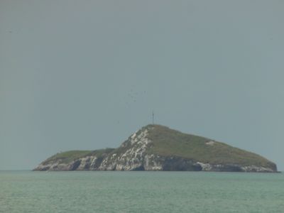
Isla Farallón, Pacific island destination in Coclé Province, Panama.
Isla Farallón is a rocky island in the Pacific Ocean that rises with steep cliffs and natural caves carved into its stone. The island has multiple vantage points where visitors can look out over the water and watch for marine life.
The island has served as a central point for Panama's fishing economy, supporting local communities through generations of maritime work. This economic importance shaped its development and continues to define its role in the region.
The island is deeply connected to local fishing traditions, showing how fisher communities have built their way of life around the ocean. These maritime practices remain visible in daily activities on and around the water.
Visitors reach the island by taking small boats from Farallón Beach, with the journey taking about 15 minutes across open water. Conditions can change throughout the day depending on weather, so checking with local operators about current conditions helps plan the visit.
A large cross stands at the highest point of the island, serving as a visible landmark for those who make the climb. This structure offers a striking reference point and the experience of looking out over surrounding Pacific waters from above.
Location: Coclé Province
GPS coordinates: 8.35370,-80.11179
Latest update: December 14, 2025 09:46
Altos de Campana National Park
43.7 km
General Division Omar Torrijos Herrera National Park
73 km
El Valle
28 km
Iglesia de Santiago Apóstol
44.5 km
Cerro Gaital
30.2 km
Saint Dominic Church of Parita
60.1 km
Casa Museo Belisario Porras
67.9 km
El Caño Archaeological Park
44.5 km
St. John Baptist Cathedral, Penonomé
33.1 km
Manuel F. Zárate House Museum
61.9 km
Finca "Pausílipo" del Doctor Belisario Porras
62.9 km
Capilla de San Juan de Dios
44.5 km
La India Dormida
29.2 km
Church of Saint Michael
54.8 km
Casa Museo Manuel F. Zárate
61.9 km
Finca Pausílipo
62.9 km
Iglesia de Santa Librada
67.9 km
Traditional architecture of Monagrillo
54.7 km
Catedral San Juan Bautista de Chitré
55.8 km
El Chorro Macho
30.5 km
Museo de la Nacionalidad
57 km
Catedral de San Juan Bautista
33.1 km
Monasterio de San Pedro
78.6 km
Plaza de Parita
60.1 km
Painted rock
29.2 km
Escuela Presidente Porras No.1
67.8 km
Iglesia de San Atanasio de Los Santos
57 km
Los Cajones de Chame
36 kmVisited this place? Tap the stars to rate it and share your experience / photos with the community! Try now! You can cancel it anytime.
Discover hidden gems everywhere you go!
From secret cafés to breathtaking viewpoints, skip the crowded tourist spots and find places that match your style. Our app makes it easy with voice search, smart filtering, route optimization, and insider tips from travelers worldwide. Download now for the complete mobile experience.
A unique approach to discovering new places❞
— Le Figaro
All the places worth exploring❞
— France Info
A tailor-made excursion in just a few clicks❞
— 20 Minutes