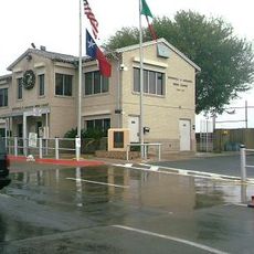
Free Trade International Bridge, Cross-border infrastructure in Los Indios, Texas and Matamoros, Tamaulipas.
The Free Trade International Bridge is a four-lane crossing that spans the Rio Grande between Los Indios in Texas and Matamoros in Tamaulipas. The structure connects these two communities and facilitates the movement of vehicles, people, and goods across the international border.
The crossing was established in 1992 by Cameron County officials to strengthen commercial ties between Texas and Tamaulipas. This new border facility became part of broader efforts to streamline trade operations along the lower Rio Grande Valley.
The bridge links two distinct communities on either side of the Rio Grande, with Los Indios representing a small Texas border town and Matamoros serving as a larger Mexican city. Daily traffic crossing here represents the constant economic exchange and human movement between the two nations.
Expect waiting times when crossing, especially during morning and afternoon rush hours. Planning your crossing outside peak traffic periods helps ensure faster passage through the checkpoint.
The facility includes specialized refrigerated inspection bays designed to maintain frozen products during border crossings. This feature sets it apart from other crossings and makes it particularly valuable for food logistics between the two countries.
Location: Texas
Location: Tamaulipas
Official opening: 1992
Part of: Mexico–United States border
GPS coordinates: 26.02917,-97.73875
Latest update: December 12, 2025 16:42
Basilica of the National Shrine of Our Lady of San Juan del Valle
45.9 km
Fort Brown
29.2 km
Gladys Porter Zoo
27.5 km
Brownsville & Matamoros International Bridge
28 km
Palo Alto Battlefield National Historical Park
27.6 km
Santa Ana National Wildlife Refuge
40.1 km
Gateway International Bridge
28.2 km
Estadio El Hogar
33.7 km
Laguna Atascosa National Wildlife Refuge
45.3 km
Lower Rio Grande Valley National Wildlife Refuge
20.9 km
Sabal Palm Sanctuary
37.7 km
Palmito Ranch Battlefield
46.3 km
Parque Olímpico
28.6 km
Our Lady of Refuge Cathedral, Matamoros
28.8 km
Fuerte Castamata
29.5 km
Immaculate Conception Cathedral
28.1 km
Resaca de la Palma Battlefield
27.3 km
Estero Llano Grande State Park
24.3 km
Old Brulay Plantation
39.1 km
Topgolf
49.8 km
Cameron County Courthouse
28.1 km
Bobz World
30.5 km
United States Court House, Custom House, and Post Office
27.8 km
Old Lyford High School
42.8 km
Pharr Aquatic Center
47.2 km
Museo del Ferrocarril de Matamoros
28 km
Iwo Jima Museum Gift Shop
22.8 km
Brownsville Heritage Museum
28.2 kmVisited this place? Tap the stars to rate it and share your experience / photos with the community! Try now! You can cancel it anytime.
Discover hidden gems everywhere you go!
From secret cafés to breathtaking viewpoints, skip the crowded tourist spots and find places that match your style. Our app makes it easy with voice search, smart filtering, route optimization, and insider tips from travelers worldwide. Download now for the complete mobile experience.
A unique approach to discovering new places❞
— Le Figaro
All the places worth exploring❞
— France Info
A tailor-made excursion in just a few clicks❞
— 20 Minutes