Chest opened
+${chestReward.xp} XP
Explorer
NOUVEAU ×${chestReward.collectible.quantity}
tapez pour fermer
Chest locked

Open chests in the app

Around Us is built for your phone — chests unlock when you walk, explore and capture nearby places.

Enable Location

We need your location to show you interesting places around you

Discover nearby places

Find interesting locations and hidden gems around you

Precise directions

Get accurate directions and distances to places

Your location is never shared with other users. It's only used when you tap the location button.

Sierra Madera crater

Log in to your account

Start exploring — it's free

Trusted by 72,961 travelers worldwide

Continue with Google
Continue with Apple
or

We will send you a code to connect

By continuing, you accept our Terms and Conditions and our Privacy Policy

Check your inbox

We've sent a pincode in your inbox. Please enter the code below.

Sierra Madera crater
Discussion Reviews 1 Photos
9.8k Popularity

Sierra Madera crater, Impact crater in Pecos County, Texas, United States

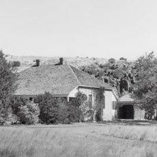
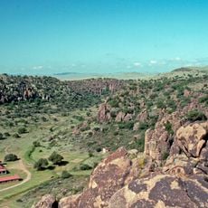
Sierra Madera crater is an impact structure in West Texas with a distinct central uplift and concentric rings visible from the ground. The landscape displays clear elevation changes where material arranged in rings, with the inner mound rising noticeably above the surroundings.

The crater formed during the Cretaceous period when a meteorite struck the region, pushing rock layers upward from significant depths. This impact event created the distinctive ring pattern visible in the landscape today.

Astronauts Gene Cernan and Jack Schmitt selected this location for geological training before their Apollo 17 lunar mission.

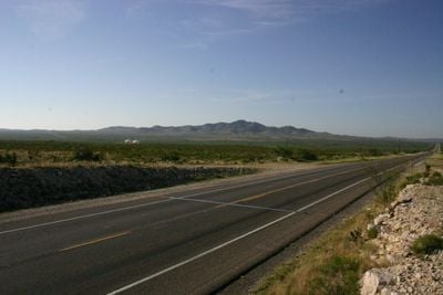
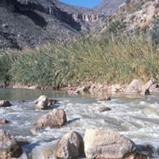
The site can be accessed via Highway 385, which runs through the crater and provides views of the geological features. The landscape is open and relatively exposed, so visitors should prepare for weather conditions and bring water.

The limestone breccia in the central peak displays fracture patterns similar to those in lunar craters like Copernicus, offering insights into impact mechanics. Astronauts have trained at this location using its structures as analogs for lunar terrain.

The community of curious travelers

AroundUs brings together thousands of curated places, local tips, and hidden gems, enriched daily by 60,000 contributors worldwide.

Start exploring
Location
GPS coordinates
30.60000,-102.91700
Latest update
December 10, 2025 15:56
Around this place
Balmorhea State Park
United States of America

Balmorhea State Park

91.3 km
Davis Mountains State Park
United States of America

Davis Mountains State Park

97.4 km
Marathon Uplift
United States of America

Marathon Uplift

53.7 km
Rio Grande Wild and Scenic River
United States of America

Rio Grande Wild and Scenic River

100.9 km
The Holland Hotel
United States of America

The Holland Hotel

76.5 km
Chihuahuan Desert Nature Center and Botanical Gardens
United States of America

Chihuahuan Desert Nature Center and Botanical Gardens

88.5 km
United States of America

Tunas Peak

65.5 km
Canon Ranch Railroad Eclipse Windmill
United States of America

Canon Ranch Railroad Eclipse Windmill

91.6 km
Jeff Davis County Courthouse
United States of America

Jeff Davis County Courthouse

93.7 km
Fort Stockton Historic District
United States of America

Fort Stockton Historic District

32.2 km
Henry M. and Annie V. Trueheart House
United States of America

Henry M. and Annie V. Trueheart House

94.4 km
Grierson-Sproul House
United States of America

Grierson-Sproul House

94.7 km
Gage Hotel
United States of America

Gage Hotel

54 km
Hotel Limpia
United States of America

Hotel Limpia

93.6 km
Museum of the Big Bend
United States of America

Museum of the Big Bend

75.2 km
Annie Riggs Memorial Museum
United States of America

Annie Riggs Memorial Museum

31.8 km
Marfa Lights Viewing Area
United States of America

Marfa Lights Viewing Area

99.5 km
Rattlers and Reptiles
United States of America

Rattlers and Reptiles

92.8 km
Granada Theatre
United States of America

Granada Theatre

76.1 km
Fort Davis
United States of America

Fort Davis

93.5 km
Rangra Theatres
United States of America

Rangra Theatres

76.3 km
Fort Davis VLBA station
United States of America

Fort Davis VLBA station

98.5 km
Princess Theater
United States of America

Princess Theater

71.6 km
Brewster County Courthouse
United States of America

Brewster County Courthouse

76.4 km
Fort Davis National Historic Site Visitor Center
United States of America

Fort Davis National Historic Site Visitor Center

93.4 km
Chinati Foundation
United States of America

Chinati Foundation

103.7 km
Fort Davis Quarters HB-14
United States of America

Fort Davis Quarters HB-14

93.5 km
Fort Davis Magazine
United States of America

Fort Davis Magazine

93.9 km
Show the full map
Reviews
Share your experience

No review yet

Discussions
Start a discussion...

No discussion yet

« Sierra Madera crater - Impact crater in Pecos County, Texas, United States » is provided by Around Us (aroundus.com). Images and texts are derived from Wikimedia project under a Creative Commons license. You are allowed to copy, distribute, and modify copies of this page, under the conditions set by the license, as long as this note is clearly visible.

Discover hidden gems everywhere you go!

From secret cafés to breathtaking viewpoints, skip the crowded tourist spots and find places that match your style. Our app makes it easy with voice search, smart filtering, route optimization, and insider tips from travelers worldwide. Download now for the complete mobile experience.

Around Us App Screenshot

A unique approach to discovering new places

Le Figaro

All the places worth exploring

France Info

A tailor-made excursion in just a few clicks

20 Minutes

Around Us
Travel Guide & Maps
Download

Send to your phone

QR Code
1

Open the camera app on your mobile.

2

Point at the QR code with your camera. A notification will appear.

3

Tap the notification to open the link.