Enable Location

We need your location to show you interesting places around you

Discover nearby places

Find interesting locations and hidden gems around you

Precise directions

Get accurate directions and distances to places

Your location is never shared with other users. It's only used when you tap the location button.

Log in to your account

Start exploring — it's free

Trusted by 62,492 travelers worldwide

Continue with Google
Continue with Apple
or

We will send you a code to connect

By continuing, you accept our Terms and Conditions and our Privacy Policy

Check your inbox

We've sent a pincode in your inbox. Please enter the code below.

Lake Granbury

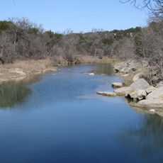
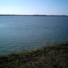
Lake Granbury, body of water

Lake Granbury is a large reservoir along the Brazos River in Texas, created in 1969 when the DeCordova Bend Dam was completed. With more than 100 miles of shoreline, the lake offers space for boating, fishing, and water recreation at multiple public access points around its banks.

Construction of the dam began in December 1966 and was completed in September 1969, creating the reservoir. The lake was built and is managed by the Brazos River Authority to control flooding and supply water for communities, industry, and agriculture in the region.

The lake serves as a gathering place for the local community, drawing fishers, boaters, and families who spend time together on and around the water. The parks and access points that line the shoreline are spaces where people naturally congregate to relax and enjoy outdoor recreation together.

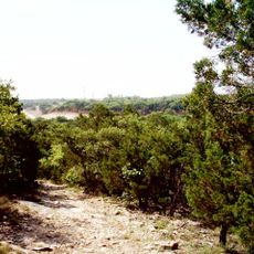
The lake has five public access points with parks, picnic areas, and basic camping facilities for visitors. It is helpful to check current water conditions and monitor any algae bloom status before planning your visit, and always follow safety guidelines when boating or swimming.

The dam and lake were not financed through tax money but rather through water sales, particularly to a power company called TXU Electric that uses it to cool power plants. This unusual funding approach shows how infrastructure projects can be realized through partnerships between public agencies and private companies.

The community of curious travelers

AroundUs brings together thousands of curated places, local tips, and hidden gems, enriched daily by 60,000 contributors worldwide.

Start exploring
Location
GPS coordinates
32.37389,-97.68778
Latest update
February 7, 2026 11:01
Around this place
Dinosaur Valley State Park
United States of America

Dinosaur Valley State Park

18.2 km
Creation Evidence Museum
United States of America

Creation Evidence Museum

19.4 km
Dinosaur World
United States of America

Dinosaur World

1565.8 km
Fossil Rim Wildlife Center
United States of America

Fossil Rim Wildlife Center

23.8 km
Cleburne State Park
United States of America

Cleburne State Park

17.1 km
Lake Pat Cleburne
United States of America

Lake Pat Cleburne

27.2 km
Acton State Historic Site
United States of America

Acton State Historic Site

7.4 km
Bluff Dale Suspension Bridge
United States of America

Bluff Dale Suspension Bridge

31.9 km
Carruthers Field
United States of America

Carruthers Field

40 km
Dinosaur World
United States of America

Dinosaur World

18.8 km
Parker County Courthouse
United States of America

Parker County Courthouse

44.1 km
Hood County Courthouse Historic District
United States of America

Hood County Courthouse Historic District

11.8 km
Johnson County Courthouse
United States of America

Johnson County Courthouse

28.5 km
Barnard's Mill
United States of America

Barnard's Mill

17.1 km
Weatherford Downtown Historic District
United States of America

Weatherford Downtown Historic District

44.1 km
Nolan River Bridge 303-A of the Gulf, Colorado and Santa Fe Railway
United States of America

Nolan River Bridge 303-A of the Gulf, Colorado and Santa Fe Railway

37.2 km
Smith Ranch
United States of America

Smith Ranch

30.5 km
Chandor Gardens
United States of America

Chandor Gardens

43.8 km
Lost Oak Winery

Lost Oak Winery

35.6 km
Movie Tavern
United States of America

Movie Tavern

43.2 km
Somervell County Courthouse
United States of America

Somervell County Courthouse

16.7 km
Church of the Holy Comforter
United States of America

Church of the Holy Comforter

28.6 km
Granbury Opera House
United States of America

Granbury Opera House

12 km
Granbury Live Theatre
United States of America

Granbury Live Theatre

12 km
Henry Briden Cabin
United States of America

Henry Briden Cabin

32.9 km
Glen Rose Downtown Historic District
United States of America

Glen Rose Downtown Historic District

16.7 km
Johnson County Feeders Supply
United States of America

Johnson County Feeders Supply

28.6 km
Granbury Railroad Depot
United States of America

Granbury Railroad Depot

12.5 km
Show the full map
« Lake Granbury - body of water » is provided by Around Us (aroundus.com). Images and texts are derived from Wikimedia project under a Creative Commons license. You are allowed to copy, distribute, and modify copies of this page, under the conditions set by the license, as long as this note is clearly visible.

Discover hidden gems everywhere you go!

From secret cafés to breathtaking viewpoints, skip the crowded tourist spots and find places that match your style. Our app makes it easy with voice search, smart filtering, route optimization, and insider tips from travelers worldwide. Download now for the complete mobile experience.

Around Us App Screenshot

A unique approach to discovering new places

Le Figaro

All the places worth exploring

France Info

A tailor-made excursion in just a few clicks

20 Minutes

Around Us
Travel Guide & Maps
Download

Send to your phone

QR Code
1

Open the camera app on your mobile.

2

Point at the QR code with your camera. A notification will appear.

3

Tap the notification to open the link.