Chest opened
+${chestReward.xp} XP
Explorer
NOUVEAU ×${chestReward.collectible.quantity}
tapez pour fermer
Chest locked

Open chests in the app

Around Us is built for your phone — chests unlock when you walk, explore and capture nearby places.

Enable Location

We need your location to show you interesting places around you

Discover nearby places

Find interesting locations and hidden gems around you

Precise directions

Get accurate directions and distances to places

Your location is never shared with other users. It's only used when you tap the location button.

Louisiana Offshore Oil Port

Log in to your account

Start exploring — it's free

Trusted by 73,104 travelers worldwide

Continue with Google
Continue with Apple
or

We will send you a code to connect

By continuing, you accept our Terms and Conditions and our Privacy Policy

Check your inbox

We've sent a pincode in your inbox. Please enter the code below.

Louisiana Offshore Oil Port
Discussion Reviews 1 Photos
13k Popularity

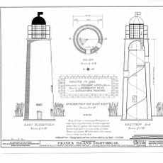
Louisiana Offshore Oil Port, Oil terminal in Gulf of Mexico, Louisiana, United States

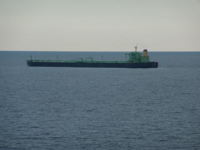
The Louisiana Offshore Oil Port is an oil transfer facility located approximately 12 nautical miles offshore in the Gulf of Mexico. It uses three single-point mooring systems where tankers dock to pump crude oil directly into pipelines that run beneath the seabed to refineries onshore.

The facility began operations in 1981 as the nation's first deepwater oil port. It was built to handle growing crude oil imports when domestic production could not meet demand.

The port represents a milestone in American industrial development, marking the evolution of maritime oil transportation infrastructure in the Gulf region.

The facility sits far offshore and is accessible only by boat or helicopter, making it closed to regular visitors. Operations run continuously throughout the year, and access is limited to authorized personnel only.

The facility connects to eight underground salt caverns deep beneath the seafloor that can store up to 40 million barrels of crude oil in natural geological formations. These salt caves provide stable storage that protects the oil from temperature changes and external conditions.

The community of curious travelers

AroundUs brings together thousands of curated places, local tips, and hidden gems, enriched daily by 60,000 contributors worldwide.

Start exploring
Location
GPS coordinates
28.88520,-90.02508
Latest update
December 7, 2025 20:42
Around this place
Fort Jackson
United States of America

Fort Jackson

76.4 km
Fort St. Philip
United States of America

Fort St. Philip

76.4 km
Fort Livingston
United States of America

Fort Livingston

43.9 km
Grand Isle State Park
United States of America

Grand Isle State Park

42.1 km
Gulf Intracoastal Waterway West Closure Complex
United States of America

Gulf Intracoastal Waterway West Closure Complex

103.7 km
Pass A L'Outre Light
United States of America

Pass A L'Outre Light

102 km
Mary Plantation House
United States of America

Mary Plantation House

102.3 km
Cathedral of St. Francis de Sales
United States of America

Cathedral of St. Francis de Sales

104.1 km
Ship Shoal Light
United States of America

Ship Shoal Light

84.8 km
Mandalay National Wildlife Refuge
United States of America

Mandalay National Wildlife Refuge

103.9 km
Harlem Plantation House
United States of America

Harlem Plantation House

83.1 km
South Pass Range Lights
United States of America

South Pass Range Lights

84.8 km
Bayou Grande Cheniere Mounds
United States of America

Bayou Grande Cheniere Mounds

71.7 km
Residence Plantation House
United States of America

Residence Plantation House

102.3 km
Promised Land
United States of America

Promised Land

101.3 km
St. Matthew's Episcopal Church
United States of America

St. Matthew's Episcopal Church

104 km
Bouverans Plantation House
United States of America

Bouverans Plantation House

95.4 km
Frank's Island Light
United States of America

Frank's Island Light

101.6 km
St. Patrick's Catholic Church
United States of America

St. Patrick's Catholic Church

74.1 km
Argyle
United States of America

Argyle

104.1 km
Merchants and Planters Bank
United States of America

Merchants and Planters Bank

98.4 km
Bank of Lockport
United States of America

Bank of Lockport

98.3 km
Bayou Terrebonne Waterlife Museum
United States of America

Bayou Terrebonne Waterlife Museum

104.2 km
Manila Village
United States of America

Manila Village

95.1 km
Chauvin Sculpture Garden & Art
United States of America

Chauvin Sculpture Garden & Art

83.1 km
Barataria Preserve
United States of America

Barataria Preserve

102.2 km
Wesley House
United States of America

Wesley House

103.5 km
Barataria Unit of Jean Lafitte Historical Park Historic District
United States of America

Barataria Unit of Jean Lafitte Historical Park Historic District

102.2 km
Show the full map
Reviews
Share your experience

No review yet

Discussions
Start a discussion...

No discussion yet

« Louisiana Offshore Oil Port - Oil terminal in Gulf of Mexico, Louisiana, United States » is provided by Around Us (aroundus.com). Images and texts are derived from Wikimedia project under a Creative Commons license. You are allowed to copy, distribute, and modify copies of this page, under the conditions set by the license, as long as this note is clearly visible.

Discover hidden gems everywhere you go!

From secret cafés to breathtaking viewpoints, skip the crowded tourist spots and find places that match your style. Our app makes it easy with voice search, smart filtering, route optimization, and insider tips from travelers worldwide. Download now for the complete mobile experience.

Around Us App Screenshot

A unique approach to discovering new places

Le Figaro

All the places worth exploring

France Info

A tailor-made excursion in just a few clicks

20 Minutes

Around Us
Travel Guide & Maps
Download

Send to your phone

QR Code
1

Open the camera app on your mobile.

2

Point at the QR code with your camera. A notification will appear.

3

Tap the notification to open the link.