Enable Location

We need your location to show you interesting places around you

Discover nearby places

Find interesting locations and hidden gems around you

Precise directions

Get accurate directions and distances to places

Your location is never shared with other users. It's only used when you tap the location button.

John James Audubon Bridge

Log in to your account

Start exploring — it's free

Trusted by 63,232 travelers worldwide

Continue with Google
Continue with Apple
or

We will send you a code to connect

By continuing, you accept our Terms and Conditions and our Privacy Policy

Check your inbox

We've sent a pincode in your inbox. Please enter the code below.

John James Audubon Bridge
Discussion Reviews 1 Photos
11.9k Popularity

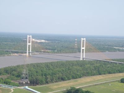
John James Audubon Bridge, Cable-stayed bridge in southern Louisiana, United States

The John James Audubon Bridge is a cable-stayed crossing spanning the Mississippi River in southern Louisiana. Two towers support the structure, which links communities situated between Natchez and Baton Rouge across the wide waterway.

The bridge opened in 2011, replacing ferry crossings that had served communities for many generations between New Roads and St. Francisville. This marked the end of a long tradition of river passage by boat.

The bridge is named after naturalist John James Audubon, reflecting the region's connection to wildlife observation and natural history. This naming choice links the crossing to the area's role in documenting North American birds.

The crossing carries standard car traffic in both directions without special requirements or closures on normal days. Travel times are generally quick, and the route functions as a primary connector for vehicles moving between the regions.

The structure includes large sliding finger joints that absorb movement from temperature changes and water conditions without affecting traffic flow. These mechanical systems represent some of the largest components of their kind ever created for bridge construction.

The community of curious travelers

AroundUs brings together thousands of curated places, local tips, and hidden gems, enriched daily by 60,000 contributors worldwide.

Start exploring
Location
Inception
2011
Official opening
May 5, 2011
GPS coordinates
30.72750,-91.35500
Latest update
December 7, 2025 20:48
Around this place
Myrtles Plantation
United States of America

Myrtles Plantation

9 km
Rosedown Plantation
United States of America

Rosedown Plantation

7.8 km
Parlange Plantation House
United States of America

Parlange Plantation House

16.6 km
Baton Rouge Zoo
United States of America

Baton Rouge Zoo

26.2 km
Butler Greenwood Plantation
United States of America

Butler Greenwood Plantation

10.8 km
Cat Island National Wildlife Refuge
United States of America

Cat Island National Wildlife Refuge

14.9 km
Port Hudson State Historic Site
United States of America

Port Hudson State Historic Site

8.4 km
Locust Grove State Historic Site
United States of America

Locust Grove State Historic Site

12.7 km
Afton Villa Gardens
United States of America

Afton Villa Gardens

14.2 km
Live Oak
United States of America

Live Oak

24.9 km
LSU Gymnastics Training Facility
United States of America

LSU Gymnastics Training Facility

5.2 km
Port Hudson National Cemetery
United States of America

Port Hudson National Cemetery

10.7 km
Allendale Plantation
United States of America

Allendale Plantation

27 km
Riverlake
United States of America

Riverlake

15.4 km
Poydras High School
United States of America

Poydras High School

8.8 km
St. Francis Chapel
United States of America

St. Francis Chapel

12.6 km
Jackson Historic District
United States of America

Jackson Historic District

18.8 km
First National Bank
United States of America

First National Bank

8.5 km
Baker Presbyterian Church
United States of America

Baker Presbyterian Church

23.6 km
Samson House
United States of America

Samson House

8.5 km
Smithfield Plantation
United States of America

Smithfield Plantation

20.7 km
Jean Baptiste Bergeron House
United States of America

Jean Baptiste Bergeron House

13.2 km
Austerlitz
United States of America

Austerlitz

16.7 km
Pointe Coupee Parish Courthouse
United States of America

Pointe Coupee Parish Courthouse

8.3 km
Southern University Historic District
United States of America

Southern University Historic District

27.3 km
Bank of Slaughter
United States of America

Bank of Slaughter

20.2 km
Satterfield Motor Company Building
United States of America

Satterfield Motor Company Building

8.5 km
Zachary Youth Park Splash pad
United States of America

Zachary Youth Park Splash pad

17.3 km
Show the full map
Reviews
Share your experience

No review yet

Discussions
Start a discussion...

No discussion yet

« John James Audubon Bridge - Cable-stayed bridge in southern Louisiana, United States » is provided by Around Us (aroundus.com). Images and texts are derived from Wikimedia project under a Creative Commons license. You are allowed to copy, distribute, and modify copies of this page, under the conditions set by the license, as long as this note is clearly visible.

Discover hidden gems everywhere you go!

From secret cafés to breathtaking viewpoints, skip the crowded tourist spots and find places that match your style. Our app makes it easy with voice search, smart filtering, route optimization, and insider tips from travelers worldwide. Download now for the complete mobile experience.

Around Us App Screenshot

A unique approach to discovering new places

Le Figaro

All the places worth exploring

France Info

A tailor-made excursion in just a few clicks

20 Minutes

Around Us
Travel Guide & Maps
Download

Send to your phone

QR Code
1

Open the camera app on your mobile.

2

Point at the QR code with your camera. A notification will appear.

3

Tap the notification to open the link.