Chest opened
+${chestReward.xp} XP
Explorer
NOUVEAU ×${chestReward.collectible.quantity}
tapez pour fermer
Chest locked

Open chests in the app

Around Us is built for your phone — chests unlock when you walk, explore and capture nearby places.

Enable Location

We need your location to show you interesting places around you

Discover nearby places

Find interesting locations and hidden gems around you

Precise directions

Get accurate directions and distances to places

Your location is never shared with other users. It's only used when you tap the location button.

Log in to your account

Start exploring — it's free

Trusted by 72,881 travelers worldwide

Continue with Google
Continue with Apple
or

We will send you a code to connect

By continuing, you accept our Terms and Conditions and our Privacy Policy

Check your inbox

We've sent a pincode in your inbox. Please enter the code below.

Interstate 65 in Alabama
Discussion Reviews Photo
40.4k Popularity

Interstate 65 in Alabama, Interstate highway through Alabama, United States

Interstate 65 is a federal highway that runs 366 miles through Alabama from the coastal city of Mobile to the Tennessee border. It connects major cities including Montgomery, Birmingham, and Huntsville along its path across the state.

The first section north of Birmingham opened in December 1959, marking the beginning of the state's interstate system. This early segment laid the foundation for the subsequent expansion and development of the Interstate network across Alabama.

The section from Georgiana to mile marker 179 carries the name Hank Williams Memorial Lost Highway to honor the country music legend. This naming reflects how deeply the region's music history shapes the identity of this stretch of road.

During hurricane evacuations, authorities can convert all lanes to northbound traffic between Mobile and Montgomery to expedite the evacuation process. Travelers should expect significantly increased traffic during these periods.

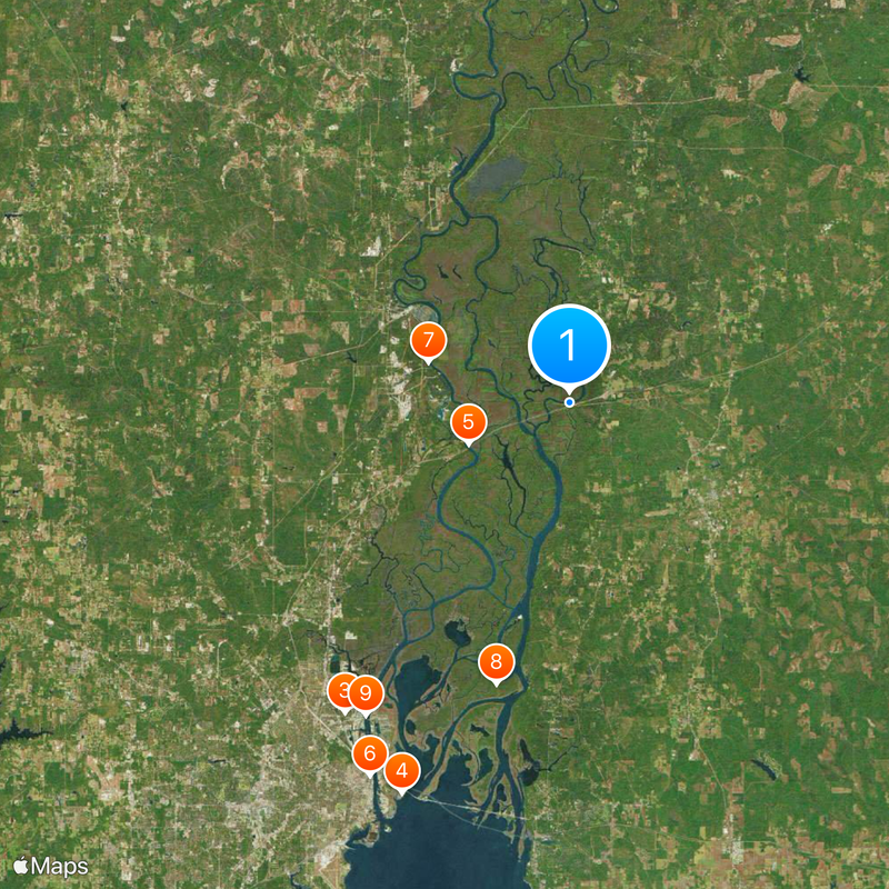
The General W.K. Wilson Jr. Bridge carries the highway across the Mobile-Tensaw River Delta and passes through wetlands in southern Alabama. This structure crosses an uncommon landscape that few travelers fully notice while driving through.

The community of curious travelers

AroundUs brings together thousands of curated places, local tips, and hidden gems, enriched daily by 60,000 contributors worldwide.

Start exploring
Location
Inception
1958
Part of
Interstate 65
GPS coordinates
30.94162,-87.88470
Latest update
December 17, 2025 08:40
Around this place
USS Alabama
United States of America

USS Alabama

31.5 km
Africatown
United States of America

Africatown

28.4 km
Battleship Memorial Park
United States of America

Battleship Memorial Park

31.5 km
General W.K. Wilson Jr. Bridge
United States of America

General W.K. Wilson Jr. Bridge

8.1 km
RSA Battle House Tower
United States of America

RSA Battle House Tower

31.4 km
United States of America

Old Mobile Site

10.8 km
Mobile-Tensaw River Delta
United States of America

Mobile-Tensaw River Delta

21.6 km
Cochrane–Africatown USA Bridge
United States of America

Cochrane–Africatown USA Bridge

27.7 km
Bottle Creek Indian Mounds
United States of America

Bottle Creek Indian Mounds

9.2 km
Meaher State Park
United States of America

Meaher State Park

30.7 km
Historic Blakeley State Park
United States of America

Historic Blakeley State Park

22.3 km
Mount Vernon Arsenal
United States of America

Mount Vernon Arsenal

21.3 km
Ellicott's Stone
United States of America

Ellicott's Stone

14.6 km
The Catholic Cemetery of Mobile
United States of America

The Catholic Cemetery of Mobile

31.5 km
Richards DAR House
United States of America

Richards DAR House

31.4 km
RSA–BankTrust Building
United States of America

RSA–BankTrust Building

31.5 km
Magee Farm
United States of America

Magee Farm

29.8 km
Aimwell Baptist Church
United States of America

Aimwell Baptist Church

31.4 km
John Archibald Campbell United States Courthouse
United States of America

John Archibald Campbell United States Courthouse

31.5 km
Chickasaw Shipyard Village Historic District
United States of America

Chickasaw Shipyard Village Historic District

27.3 km
First National Bank
United States of America

First National Bank

31.4 km
Coley Building
United States of America

Coley Building

31.4 km
Latham United Methodist Church
United States of America

Latham United Methodist Church

18.2 km
First Baptist Church
United States of America

First Baptist Church

12.1 km
Emanuel Building
United States of America

Emanuel Building

31.4 km
Montgomery Hill Baptist Church
United States of America

Montgomery Hill Baptist Church

26.3 km
Nelson House
United States of America

Nelson House

16.8 km
Davis-Oak Grove District
United States of America

Davis-Oak Grove District

30.2 km
Show the full map
Reviews
Share your experience

No review yet

Discussions
Start a discussion...

No discussion yet

« Interstate 65 in Alabama - Interstate highway through Alabama, United States » is provided by Around Us (aroundus.com). Images and texts are derived from Wikimedia project under a Creative Commons license. You are allowed to copy, distribute, and modify copies of this page, under the conditions set by the license, as long as this note is clearly visible.

Discover hidden gems everywhere you go!

From secret cafés to breathtaking viewpoints, skip the crowded tourist spots and find places that match your style. Our app makes it easy with voice search, smart filtering, route optimization, and insider tips from travelers worldwide. Download now for the complete mobile experience.

Around Us App Screenshot

A unique approach to discovering new places

Le Figaro

All the places worth exploring

France Info

A tailor-made excursion in just a few clicks

20 Minutes

Around Us
Travel Guide & Maps
Download

Send to your phone

QR Code
1

Open the camera app on your mobile.

2

Point at the QR code with your camera. A notification will appear.

3

Tap the notification to open the link.