Enable Location

We need your location to show you interesting places around you

Discover nearby places

Find interesting locations and hidden gems around you

Precise directions

Get accurate directions and distances to places

Your location is never shared with other users. It's only used when you tap the location button.

William "Bill" Dannelly Reservoir

Log in to your account

Start exploring — it's free

Trusted by 62,475 travelers worldwide

Continue with Google
Continue with Apple
or

We will send you a code to connect

By continuing, you accept our Terms and Conditions and our Privacy Policy

Check your inbox

We've sent a pincode in your inbox. Please enter the code below.

William "Bill" Dannelly Reservoir

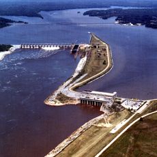
William "Bill" Dannelly Reservoir, body of water

William 'Bill' Dannelly Reservoir is a large man-made lake situated along the Alabama River with open water and wooded shores throughout its length. The shoreline consists of wetlands, creek systems, and gentle hills that provide multiple access points for fishing, boating, and kayaking activities.

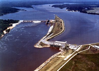
The reservoir was created in 1969 when the U.S. Army Corps of Engineers dammed the Alabama River, with operations beginning in 1970. Since its completion, the dam has powered electricity generation for nearby communities and improved navigation safety along the waterway.

The area holds significance for Native American history and the Civil Rights Movement that shaped the region. The local name Millers Ferry reflects the ferry crossing that once operated here before the dam was constructed.

The area includes several parks and campgrounds such as Roland Cooper State Park, which offers cabins, a golf course, and boat ramps for visitors. The nearby town of Camden provides hotels, restaurants, and shops where you can find fishing gear and supplies.

The reservoir serves as the starting point for the Alabama Scenic River Trail, the longest water trail within a single state. The paddle route extends through multiple river systems and concludes at the Gulf of Mexico, passing through some of the region's most natural areas.

The community of curious travelers

AroundUs brings together thousands of curated places, local tips, and hidden gems, enriched daily by 60,000 contributors worldwide.

Start exploring
Location
GPS coordinates
32.11967,-87.39830
Latest update
February 9, 2026 08:19
Around this place
Faunsdale Plantation
United States of America

Faunsdale Plantation

40.1 km
Cahaba Prison
United States of America

Cahaba Prison

35.9 km
Adams Grove Presbyterian Church
United States of America

Adams Grove Presbyterian Church

38.6 km
Fairhope Plantation
United States of America

Fairhope Plantation

37.3 km
Cedar Grove Plantation
United States of America

Cedar Grove Plantation

40.2 km
Millers Ferry Lock and Dam
United States of America

Millers Ferry Lock and Dam

2.1 km
Snow Hill Normal and Industrial Institute
United States of America

Snow Hill Normal and Industrial Institute

36.3 km
St. Luke's Episcopal Church
United States of America

St. Luke's Episcopal Church

35.4 km
Altwood
United States of America

Altwood

42.7 km
Half Chance Iron Bridge
United States of America

Half Chance Iron Bridge

36 km
Westwood
United States of America

Westwood

39.4 km
William Poole House
United States of America

William Poole House

34.5 km
Street Manual Training School
United States of America

Street Manual Training School

31.9 km
William King Beck House
United States of America

William King Beck House

10.2 km
C. S. Golden House
United States of America

C. S. Golden House

27.3 km
Uniontown Historic District
United States of America

Uniontown Historic District

39.4 km
Oak Hill Historic District
United States of America

Oak Hill Historic District

37.1 km
Ackerville Baptist Church of Christ
United States of America

Ackerville Baptist Church of Christ

32.6 km
Airmount Grave Shelter
United States of America

Airmount Grave Shelter

30.6 km
Carlowville Historic District
United States of America

Carlowville Historic District

35 km
Furman Historic District
United States of America

Furman Historic District

42.7 km
Thomaston Colored Institute
United States of America

Thomaston Colored Institute

27.7 km
Wilcox Female Institute
United States of America

Wilcox Female Institute

17.1 km
Wilcox County Courthouse Historic District
United States of America

Wilcox County Courthouse Historic District

17.6 km
Thomasville Historic District
United States of America

Thomasville Historic District

39.4 km
Patrick Farrish House
United States of America

Patrick Farrish House

26.6 km
Thomaston Central Historic District
United States of America

Thomaston Central Historic District

27.1 km
Rikard's Mill Historical Park
United States of America

Rikard's Mill Historical Park

41 km
Show the full map
« William "Bill" Dannelly Reservoir - body of water » is provided by Around Us (aroundus.com). Images and texts are derived from Wikimedia project under a Creative Commons license. You are allowed to copy, distribute, and modify copies of this page, under the conditions set by the license, as long as this note is clearly visible.

Discover hidden gems everywhere you go!

From secret cafés to breathtaking viewpoints, skip the crowded tourist spots and find places that match your style. Our app makes it easy with voice search, smart filtering, route optimization, and insider tips from travelers worldwide. Download now for the complete mobile experience.

Around Us App Screenshot

A unique approach to discovering new places

Le Figaro

All the places worth exploring

France Info

A tailor-made excursion in just a few clicks

20 Minutes

Around Us
Travel Guide & Maps
Download

Send to your phone

QR Code
1

Open the camera app on your mobile.

2

Point at the QR code with your camera. A notification will appear.

3

Tap the notification to open the link.